
MyTopo
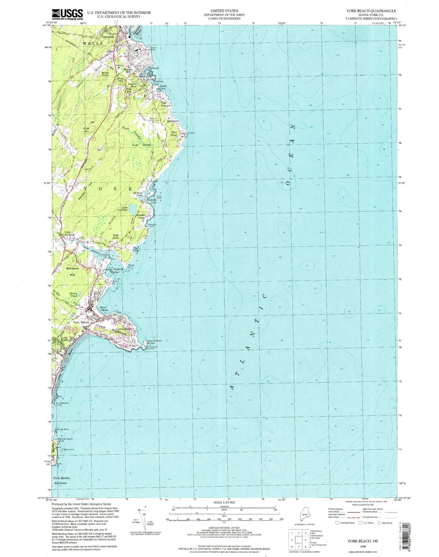
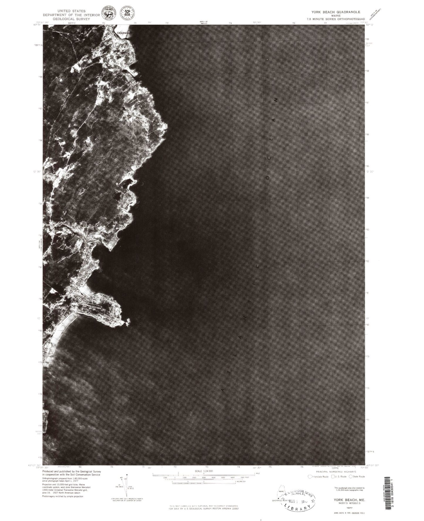
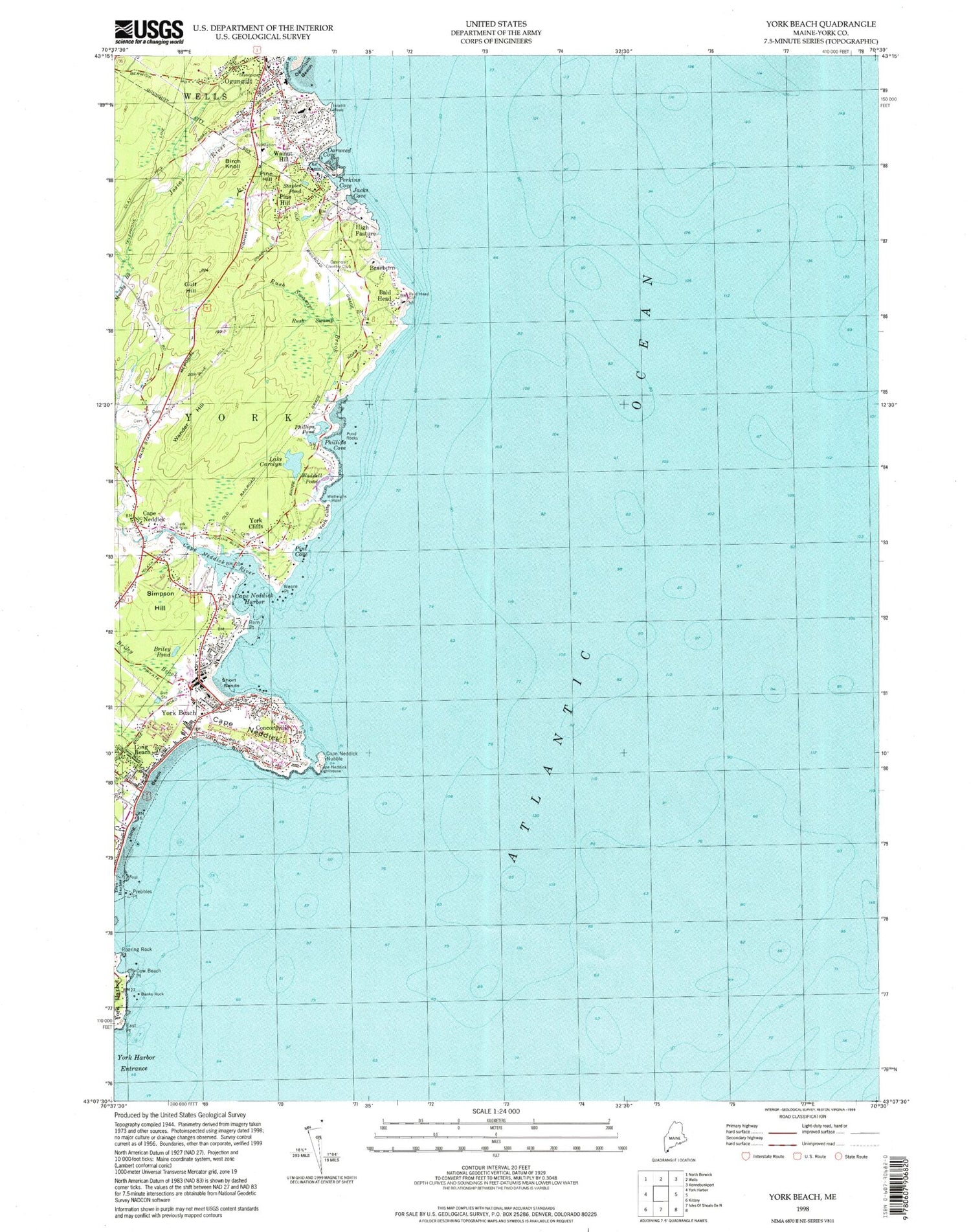
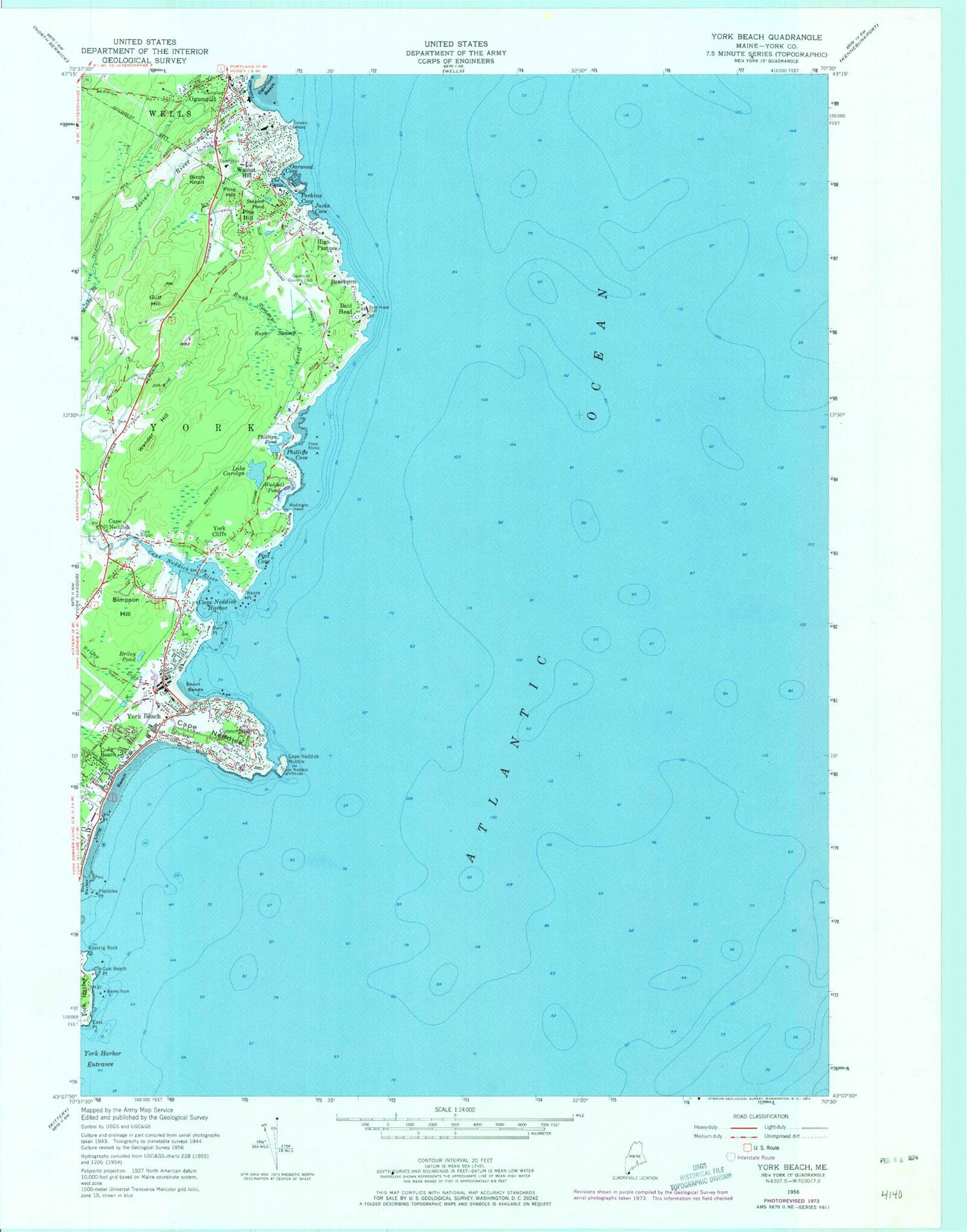
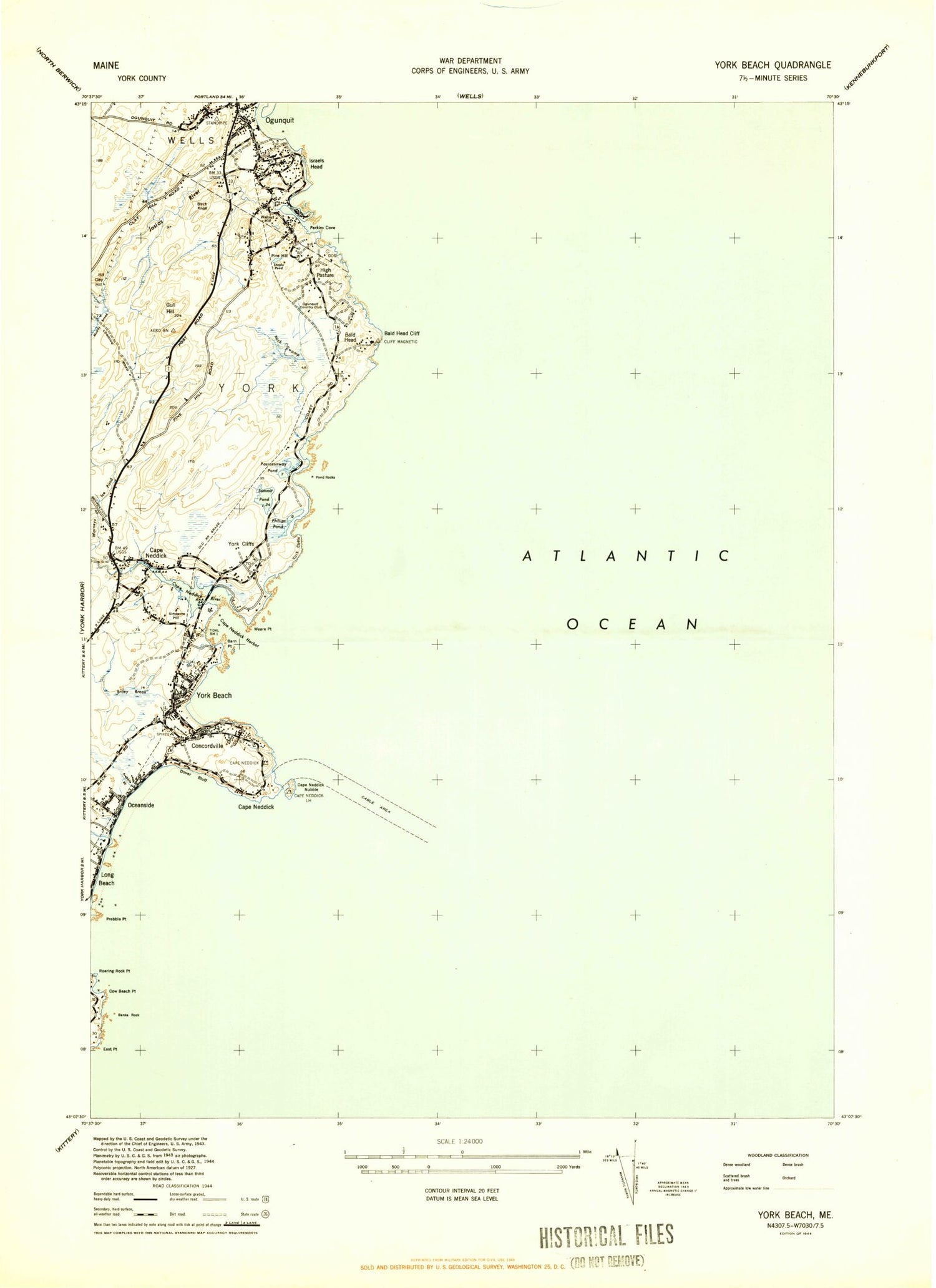
Classic USGS York Beach Maine 7.5'x7.5' Topo Map
Couldn't load pickup availability
Historical USGS topographic quad map of York Beach in the state of Maine. Typical map scale is 1:24,000, but may vary for certain years, if available. Print size: 24" x 27"
This quadrangle is in the following counties: York.
The map contains contour lines, roads, rivers, towns, and lakes. Printed on high-quality waterproof paper with UV fade-resistant inks, and shipped rolled.
Contains the following named places: Bald Head, Bald Head Cliff, Banks Rock, Barn Point, Birch Knoll, Braeburn, Briley Brook, Briley Pond, Cape Neddick, Cape Neddick, Cape Neddick Harbor, Cape Neddick Light, Cape Neddick Nubble, Cape Neddick River, Lake Carolyn, Clark Bridge, Concordville, Cow Beach Point, Dover Bluff, East Point, Gulf Hill, High Pasture, Israels Head, Jacks Cove, Josias River, Long Beach, Long Beach, Muddy Brook, Oarweed Cove, Ogunquit, Ogunquit River, Perkins Cove, Phillips Cove, Phillips Pond, Pine Hill, Pine Hill, Pint Cove, Pond Rocks, Prebbles Point, Roaring Rock Point, Rush Swamp, Rush Swamp Brook, Short Sands, Simpson Hill, Staples Pond, The Basin, Waddell Pond, Wadleighs Head, Walnut Hill, Wander Hill, Weare Point, York Beach, York Cliffs, York Cliffs, York Harbor Entrance, Ogunquit Country Club, Town of Ogunquit, Town of York, All Saints Catholic Church, Cape Neddick Baptist Church, Cape Neddick Beach, Cape Neddick Campground, Cape Neddick Park, Cape Neddick Post Office, Clay Hill, Dixons Campground, Flaggs Trailer Park, Little Beach, Mayo Falls, Nubble Point, Ocean View Village, Ogunquit Art Association Gallery, Ogunquit Baptist Church, Ogunquit Information Bureau, Ogunquit Memorial Library, Ogunquit Museum of American Art, Ogunquit Playhouse, Ogunquit Post Office, Ogunquit United Methodist Church, Ogunquit Village School, Prebble Brook, S Judson Dunaway Center, Saint Peters By-The-Sea Church, Sohier Park, The Blacksmith Mall Shopping Center, Union Congregational Church, Wayside Trailer Park, Worleys Ice Pond (historical), York Beach Camper Park, York Beach Fire Station, York Beach Post Office, York Cliff Historic District, Yorks Wild Kingdom, Cape Neddick Census Designated Place, Ogunquit Fire Department, Ogunquit Police Department, Currier Cemetery, Prebble Lot, Littlefield Cemetery, Littlefield Lot, Samuel Littlefield Lot, Locust Grove Cemetery, Jeremiah Lord Lot, Samuel Lord Cemetery, Matthews Cemetery, James Weare Lot, William Weare Lot, Weare Lot, Donnell Weare Lot, Weare Lot, Jeremiah Weare Lot, Webber - Merrow Cemetery, Welch Lot, York Beach Cemetery, York Beach Veterans Memorial Cemetery, Jeremiah Freeman Lot, Stephen Freeman Lot, Freeman Lot, Freeman Lot, Goodwin Lot, Adams Lot, Allen Lot, Solomon Avery Lot, Charles Bragdon Family Lot, George Brooks Lot, Caswell Barton Lot, Clark Road Cemetery, John Norton Lot, William Norton Lot, Oliver Norton Lot, Samuel Norton Lot, Theodore Parsons Lot, Jedediah Perkins Lot, Elias Perkins Lot, Perkins Lot, Jedediah Perkins Lot, Perkins Lot, Perkins - White Lot, Edward Phillips Lot, Mark Hutchins Lot, Ramsdell Lot, Cape Neddick Baptist Church Cemetery, William Simpson Lot Cemetery, George Simpson Lot, Francis Staples Lot, Talpey Lot, Talpey Lot, Bald Head, Bald Head Cliff, Banks Rock, Barn Point, Birch Knoll, Braeburn, Briley Brook, Briley Pond, Cape Neddick, Cape Neddick, Cape Neddick Harbor, Cape Neddick Light, Cape Neddick Nubble, Cape Neddick River, Lake Carolyn, Clark Bridge, Concordville, Cow Beach Point, Dover Bluff, East Point, Gulf Hill, High Pasture, Israels Head, Jacks Cove, Josias River, Long Beach, Long Beach, Muddy Brook, Oarweed Cove, Ogunquit, Ogunquit River, Perkins Cove, Phillips Cove, Phillips Pond, Pine Hill, Pine Hill, Pint Cove, Pond Rocks, Prebbles Point, Roaring Rock Point, Rush Swamp, Rush Swamp Brook, Short Sands, Simpson Hill, Staples Pond, The Basin, Waddell Pond, Wadleighs Head, Walnut Hill, Wander Hill, Weare Point, York Beach, York Cliffs, York Cliffs, York Harbor Entrance, Ogunquit Country Club, Town of Ogunquit, Town of York, All Saints Catholic Church, Cape Neddick Baptist Church, Cape Neddick Beach, Cape Neddick Campground, Cape Neddick Park, Cape Neddick Post Office, Clay Hill, Dixons Campground, Flaggs Trailer Park, Little Beach, Mayo Falls, Nubble Point, Ocean View Village, Ogunquit Art Association Gallery, Ogunquit Baptist Church, Ogunquit Information Bureau, Ogunquit Memorial Library, Ogunquit Museum of American Art, Ogunquit Playhouse, Ogunquit Post Office, Ogunquit United Methodist Church, Ogunquit Village School, Prebble Brook, S Judson Dunaway Center, Saint Peters By-The-Sea Church, Sohier Park, The Blacksmith Mall Shopping Center, Union Congregational Church, Wayside Trailer Park, Worleys Ice Pond (historical), York Beach Camper Park