MyTopo
Bel Air Maryland US Topo Map
Couldn't load pickup availability
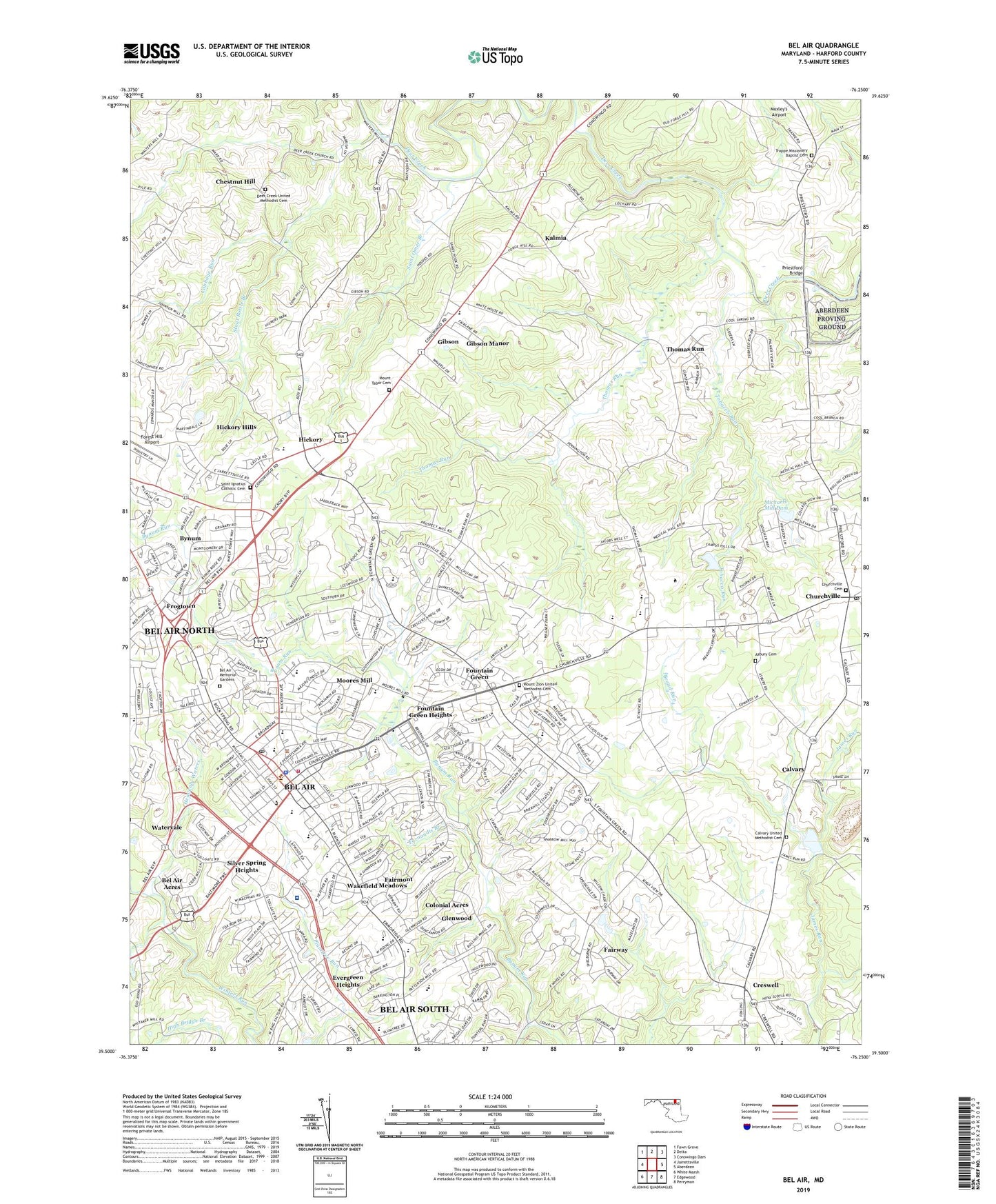
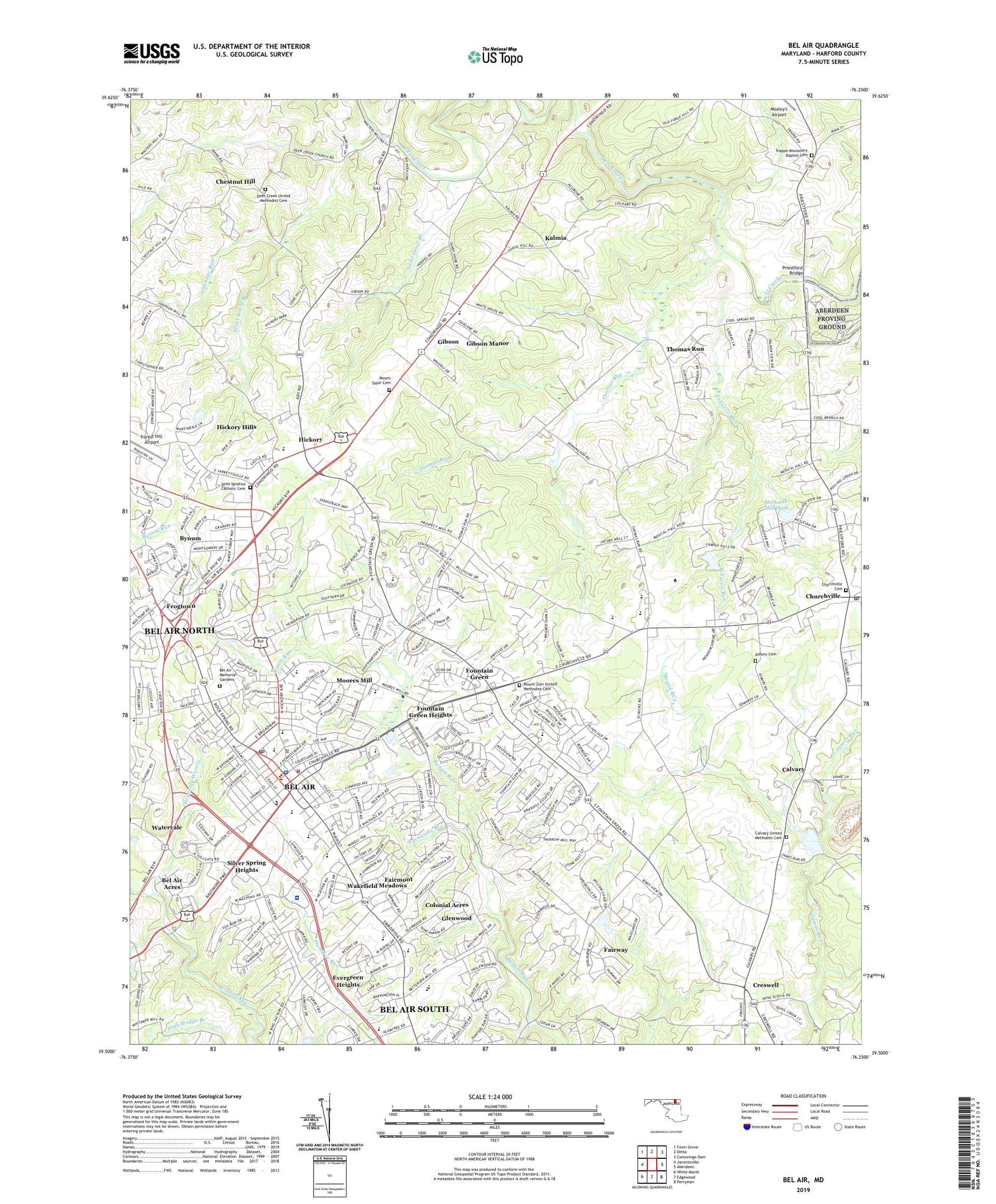
2019 topographic map quadrangle Bel Air in the state of Maryland. Scale: 1:24000. Based on the newly updated USGS 7.5' US Topo map series, this map is in the following counties: Harford. The map contains contour data, water features, and other items you are used to seeing on USGS maps, but also has updated roads and other features. This is the next generation of topographic maps. Printed on high-quality waterproof paper with UV fade-resistant inks.
Quads adjacent to this one:
West: Jarrettsville
Northwest: Fawn Grove
North: Delta
Northeast: Conowingo Dam
East: Aberdeen
Southeast: Perryman
South: Edgewood
Southwest: White Marsh
Contains the following named places: Allendale Estates, Allibone, Alternative Center/Bel Air High School, Amyclae Estates, Aquila Scott Park, Asbury Cemetery, Bel Air, Bel Air Acres, Bel Air Commercial Park, Bel Air Convalescent Center, Bel Air Courthouse Historic District, Bel Air Elementary School, Bel Air High School, Bel Air Memorial Gardens, Bel Air Middle School, Bel Air North Census Designated Place, Bel Air Park, Bel Air Plaza Shopping Center, Bel Air South Census Designated Place, Bel Air Town Shopping Center, Belair Academy, Big Woods, Bradford Village, Bramblewood, Brentwood Park, Brierwood, Bright Oaks, Broad Run, Bynum, Bynum Run Park, Bynum Run Picnic Area, Cabbage Run, Calvary, Calvary United Methodist Cemetery, Camelot, Campus Hill Farms, Campus Hills Estates, Campus Hills Pond, Campus Hills Pond Dam, Campus Hills Shopping Center, Campus Valley Estates, Cedar Spring, Charles Milton Wright High School, Chatham, Chestnut Hill, Childrens Fresh Air Camp, Churchville Cemetery, Churchville Quarry, Coffman, Colonial Acres, Cool Spring, Corns Manor, Country Club Park, Country Village, County Home Park, Creswell, Deer Creek United Methodist Cemetery, Deercreek, Deerhaven, District 3 Bel Air, Drexel, Eagle Estates, Emmorton Baptist Academy, English Country Manor, Evergreen Heights, Evermar Farms, Fairmont, Fairway, Fairwind Farms, Fairwood Heights, Farnandis Branch, Forest Hill Airport, Forest Hill Industrial Airpark, Forest Lawn, Fountain Glen, Fountain Green, Fountain Green Elementary School, Fountain Green Estates, Fountain Green Heights, Fountain Green Mobile Home Park, Fountain Green Plaza Shopping Center, Fox Bow, Foxborough Farms, Friendship Heights, Frogtown, Gatch Quarry, Gibson, Gibson Manor, Glenangus, Glengate, Glenwood, Glenwood Garth, Grafton Heights, Green Ridge, Greenbrier Hills, Grose Close, Hampton Ridge, Harford Community College, Harford Community College - Aberdeen Hall, Harford County, Harford County Health and Welfare Center, Harford Dale, Harford Day School, Harford Hills, Harford Mall Business Center, Harford Mall Shopping Center, Harford Ranchettes, Harford Technical High School, Harford Village, Harford Woods, Harlan Square, Harold Heights, Heavenly Waters, Heavenly Waters Park, Hemlock Ridge, Heritage Woods, Hickory, Hickory Elementary School, Hickory Hills, Hickory Park, Hickory Village Mobile Home Park, Hiddenbrook Treatment Center, Highlands School, Hill-N-Dale, Hillview, Homestead / Wakefield Elementary School, Homestead Park, Homestead Village, Howard Park, John Archer School, John Carroll High School, Joppa Hills, Kalmia, Kings Charter, Knollwood, Leew Woods, Lindill Estates, Locust Knoll, Longmeadow, Lyns Rest, Magness, Main Street Shopping Center, Majors Choice, Majors Choice Park, Martindale, Maryland Country Club, Maryland Ponderosa, Marywood, McPhail Crossing Shopping Center, Meadow Springs, Mechanicsville, Melrose, Michaels Corner, Michaels Meadows, Michaels Mill Dam, Monarch Montessori School Kindergarten, Moores Mill, Moorland, Morgan Park, Mount Tabor Cemetery, Mount Zion United Methodist Cemetery, Moxley Acres, North Bel Air, Northridge, Oak Dale, Oak Ridge, Old Dixie Manor, Old Fields, Palmer State Park, Parsons Ridge, Patterson Mill Middle / High School, Pegasus Estates, Pheasant Ridge, Pine Crest, Plum Tree Park, Priestford Bridge, Priestford Hills, Priestford Hills Dam, Prospect Heights, Prospect Mill Elementary School, Ring Factory Elementary School, Rock Spring Shopping Center, Roland Heights, Roland Place, Ruffs Mill, Sable Woods, Saint Ignatius Catholic Cemetery, Saint Margarets School, Saint Omer Branch, Sandy Hook, Schucks Corners, Scots Fancy, Shamrock, Shamrock Park, Shucks Corners, Silver Spring Heights, South Bel Air, Southampton, Southampton Middle School, Stonehedge, Stoneleigh, Stoney Forest Demonstration Area, Stout Bottle Branch, Sylvan Gorge Burn, Thomas Run, Thomas Run Park, Tobacco Run, Todd Estates, Todd Lakes, Tollgate Estates, Tollgate Mall Shopping Center, Town of Bel Air, Trappe Missionary Baptist Cemetery, Tudor Forest, Tudor Manor, Upper Chesapeake Medical Center, Upper Crest Estates, Village of Thomas Run, Voshelle, Wakefield Manor, Wakefield Meadows, Wakely Terrace, WAMD-AM (Hickory Hills), Warwick, Watervale, Wellington Woods, West Riding, WHFC-FM (Bel Air), White Oak, WHRF-AM (Bel Air), Woodside, Worthington Heights, Wyndemede Industrial Park, ZIP Codes: 21014, 21015