MyTopo
Beltsville Maryland US Topo Map
Couldn't load pickup availability
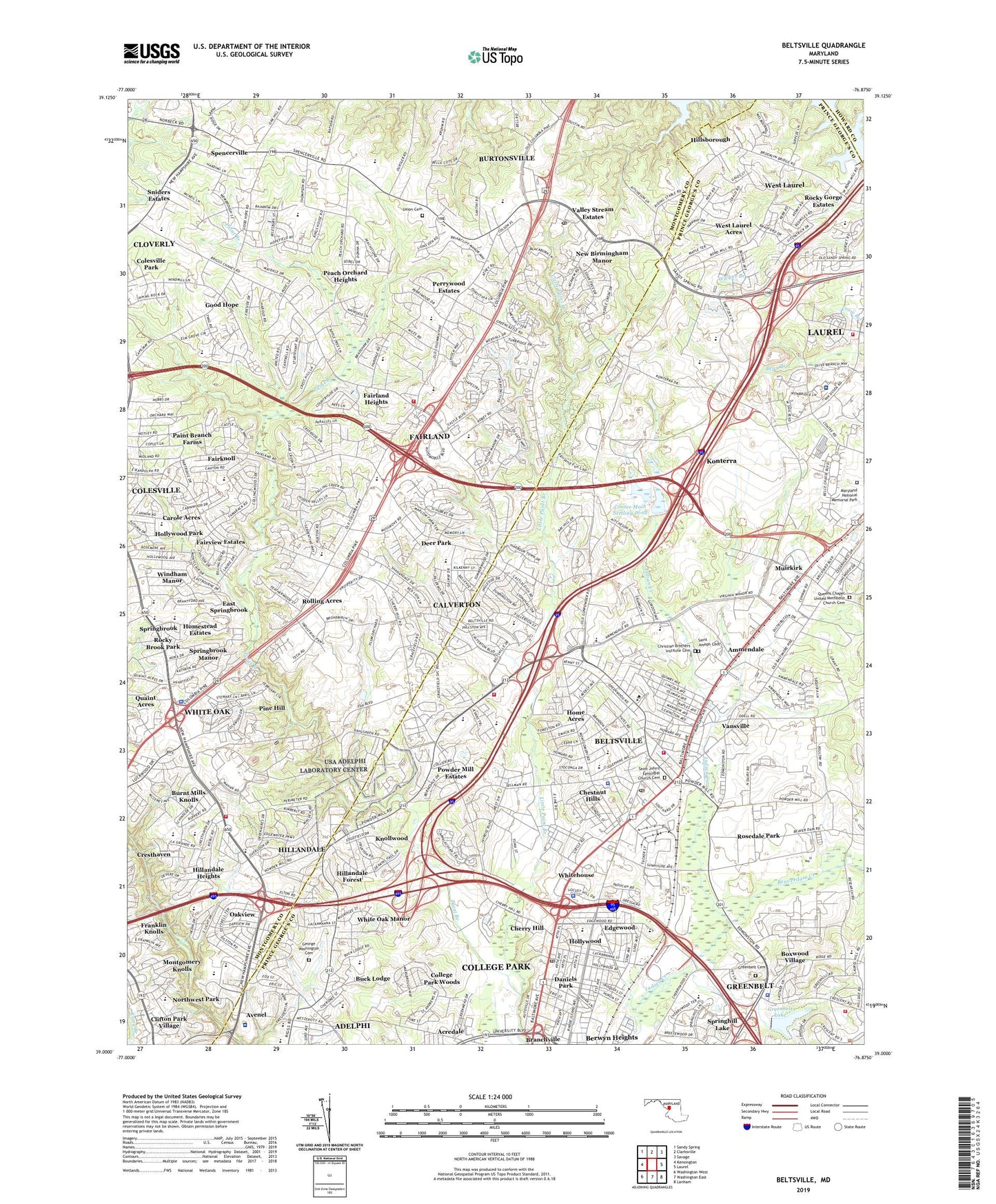
2019 topographic map quadrangle Beltsville in the state of Maryland. Scale: 1:24000. Based on the newly updated USGS 7.5' US Topo map series, this map is in the following counties: Prince George's, Montgomery, Howard. The map contains contour data, water features, and other items you are used to seeing on USGS maps, but also has updated roads and other features. This is the next generation of topographic maps. Printed on high-quality waterproof paper with UV fade-resistant inks.
Quads adjacent to this one:
West: Kensington
Northwest: Sandy Spring
North: Clarksville
Northeast: Savage
East: Laurel
Southeast: Lanham
South: Washington East
Southwest: Washington West
Contains the following named places: Acredale, Adelphi, Adelphi Census Designated Place, Adelphi Elementary School, Adelphi Laboratory Center, Adelphi Recreation Center, Ammendale, Ammendale Business Campus, Ammendale Normal Institute, Avenel, Beaverdam Creek, Beltsville, Beltsville Academy, Beltsville Census Designated Place, Beltsville Heights, Beltsville Industrial Center, Beltsville Industrial Park, Beltsville North Park, Beltsville School, Blackburn Village, Bond Mill Park, Boxwood Village, Briggs Chaney Shopping Center, Briggs-Chaney Estates, Brookview School, Browns Corner, Buck Lodge, Burnt Mills Census Designated Place, Burnt Mills Hills, Burnt Mills Knolls, Burtonsville, Burtonsville Census Designated Place, Burtonsville Commerce Center, Burtonsville Crossing Shopping Center, Burtonsville Industrial Park, Burtonsville Lookout Tower, Burtonsville Park, Calverton, Calverton Census Designated Place, Calverton Park, Capitol Office Park, Carole Acres, Carriage Hill, Castlegate, Cedarcroft Sanitorium, Cherry Hill, Cherry Hill Road Recreation Center, Cherrywood, Chestnut Hills, Chestnut Hills Shopping Center, Christian Brothers Institute Cemetery, Citizens Bank Headquarters Heliport, Clifton Park Village, Cloverly, Cloverly Census Designated Place, Cloverly Elementary School, Cloverly Park, Cloverly Village Shopping Center, Colesville Heights, Colesville School, College Park Woods, Columbia Park, Contee Main Settling Pond, Contee Main Settling Pond Dam, Cresthaven, Cresthaven Elementary School, Cross Creek Golf Club, Daniels Park, Deer Park, District 1 Vansville, District 21 Berwyn, District 5, Dow Jones and Company Incorporated Heliport, East Fairland Park, East Springbrook, Edgewood, Edgewood Park, Eleven Cedars, Fairknoll, Fairland, Fairland Acres, Fairland Census Designated Place, Fairland Estates, Fairland Farms, Fairland Heights, Fairland Recreational Park, Fairview, Fairview Estates, Franklin Knolls, Galway Park, George Washington Cemetery, Gladys Spellman Specialty Care Unit, Good Hope, Good Hope Estates, Good Hope Park, Greater Laurel Beltsville Hospital, Greater Laurel Beltsville Hospital Heliport, Greater Laurel Professional Park, Green Castle Woods, Greenbelt, Greenbelt Cemetery, Greenbelt Dam, Greenbelt Lake, Greenbelt Lake Park, Greenbelt Metro Station, Greencastle Manor, Gum Springs, Gunpowder Road Golf Course, Hillandale, Hillandale Census Designated Place, Hillandale Forest, Hillandale Heights, Hillandale School, Hillandale Shopping Center, Hillsborough, Holly Tree Estates, Hollywood, Hollywood Park, Hollywood Recreation Center, Home Acres, Homestead Estates, Island Plaza Shopping Center, Jackson Road Elementary School, JoAnn Leleck Elementary School, Knightsbridge, Knollwood, Konterra Business Campus, Konterra Census Designated Place, Laurel Employment Park, Laurel Oaks, Lewiston, Little Paint Branch, Little Paint Branch Park, Long Branch Park, Maidens Fancy Manor, Martin Luther King Recreational Park, Maryland 95 Corporate Park, Maryland National Memorial Park, Maydale, Mayfair, McCahill Estates, Monteith, Montgomery Auto Park, Montgomery Industrial Park, Montgomery Knolls, Montgomery Knolls Elementary School, Muirkirk, Naval Surface Warefare Center, New Birmingham Manor, Northwest Branch Park, Northwest Park, Oak Springs, Oakhurst, Oakview, O'Keefe Orchard, Olne Acres Poultry Farm, Orchard View, Paint Branch Estates, Paint Branch Farms, Paint Branch Golf Course, Paint Branch Park, Parrs Ridge, Peach Orchard Heights, Peach Wood Park, Perrywood Estates, Pine Hill, Powder Mill Community Park, Powder Mill Estates, Quaint Acres, Quebec Terrace Park, Queens Chapel United Methodist Church Cemetery, Riding Stable Estates, Robeys Farmlets, Rocky Acres, Rocky Brook Park, Rocky Gorge Estates, Rolling Acres, Rosedale Park, Rusty Acres, Saddle Creek, Saint Francis International School, Saint John's Episcopal Church Cemetery, Saint Joseph Cemetery, Saint Luke Institute, Sandy Spring Estates, Scotchtown Hills, Sellman Estates, Sequoia, Silver Spring Industrial Park, Smithville, Sniders Estates, Spencerville, Spencerville Census Designated Place, Spencerville Junior Academy, Spencerville Knolls, Spencerville Recreation Center, Springbrook, Springbrook Manor, Springhill Lake, Stonewood, Sunnyside, Ulles Crossing, Union Cemetery, United States Department of Agriculture Research Center, University of Maryland Laurel Regional Hospital, University of Maryland Plant Research Farm, Valley Stream Estates, Vansville, Vansville Park, Virginia Manor, Virginia Manor Industrial Park, Walker Hill, West Fairland Park, West Laurel, West Laurel Acres, West Laurel Census Designated Place, West Laurel Park, White Oak, White Oak Census Designated Place, White Oak Golf Course, White Oak Manor, White Oak Middle School, White Oak Shopping Center, Whitehouse, Wilshire, Windham Manor, Wyndham Woods, ZIP Codes: 20705, 20707, 20740, 20770, 20866, 20903, 20904, 20905