MyTopo
Benedict Maryland US Topo Map
Couldn't load pickup availability
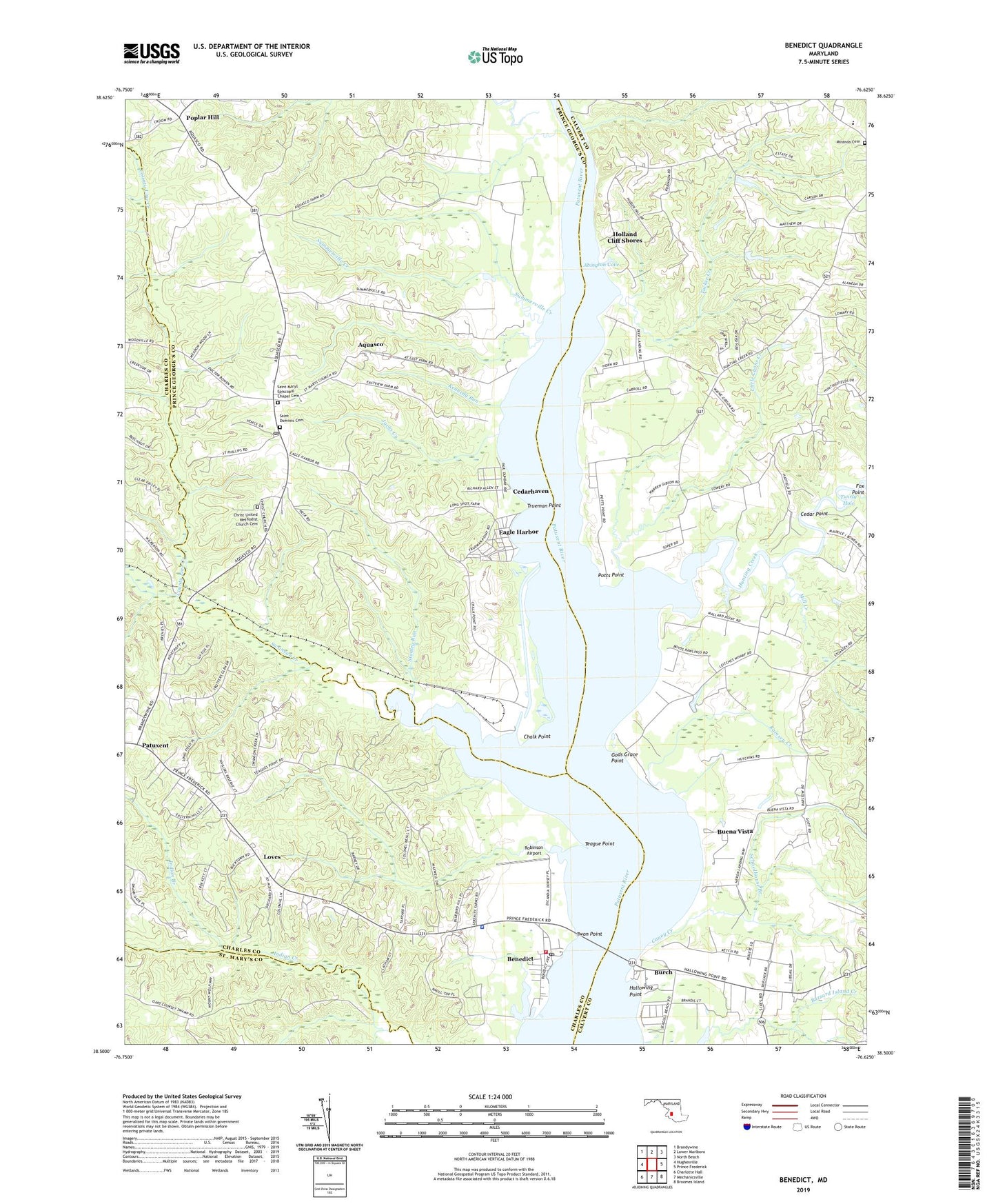
2019 topographic map quadrangle Benedict in the state of Maryland. Scale: 1:24000. Based on the newly updated USGS 7.5' US Topo map series, this map is in the following counties: Calvert, Prince George's, Charles, St. Mary's. The map contains contour data, water features, and other items you are used to seeing on USGS maps, but also has updated roads and other features. This is the next generation of topographic maps. Printed on high-quality waterproof paper with UV fade-resistant inks.
Quads adjacent to this one:
West: Hughesville
Northwest: Brandywine
North: Lower Marlboro
Northeast: North Beach
East: Prince Frederick
Southeast: Broomes Island
South: Mechanicsville
Southwest: Charlotte Hall
Contains the following named places: Abington Cove, Abington Shores, Anchorage Park Mobile Home Park, Aquasco, Aquasco Census Designated Place, Aquasco Post Office, Aquasco Speedway, Benedict, Benedict Census Designated Place, Benedict Post Office, Benedict School, Benedict Volunteer Fire Department and Rescue Squad, Buena Vista, Buena Vista on the Patuxent, Buenavista Post Office, Burch, Calvert County Industrial Park, Calvert Mobile Home Park, Caney Creek, Cedar Beach, Cedar Hill School, Cedar Point, Cedarhaven, Chalk Point, Chalk Point Generating Sta Heliport, Christ United Methodist Church Cemetery, County Line Creek, Cox, Deep Landing, Deep Landing Estates, Deerfield, District 8 Aquasco, District 9 Hughesville, Eagle Harbor, Fiddlers Point, Fox Den, Fox Point Creek, Gibson Meadows, Gods Grace Point, Hallmark Estates, Hallowing Point, Hallowing Point Park, Holland Cliff, Holland Cliff Shores, Holland Glenn, Hunting Creek, Hunting Lake, Huntingtown Elementary School, Indian Branch, Indian Creek Estates, Jacks Creek, John Wesley Church, Kennedy Run, Kings Landing Academy Day School, Kings Landing Park, Kings Landing Pier, Leitch Wharf, Little Lyons Creek, Loves, Lowery Oaks, Lowrys Resurvey, Maryland Natural Resource Police Southern Region Indian Creek Office, Maxwell Hall, Meadow Woods Estates, Mill Creek, Miranda Cemetery, New Enterprise, Patuxent, Patuxent River Natural Resource Management Area, Patuxent View, Patuxent Woods, Poplar Hill, Potts Point, Quail Ridge, Ramsey Creek, Robinson Airport, Saint Dominic Cemetery, Saint Dominics Catholic Church, Saint Francis De Sales Catholic Church, Saint Marys Episcopal Chapel Cemetery, Saint Marys Episcopal Church, Schoolhouse Branch, Shady Hill, Shady Hill Farm, Stanley Run, Summerville Creek, Swanson Creek, Swanson Creek Landing, Teague Point, Teagues Point, The Alameda, The Oaks, Town of Eagle Harbor, Trueman Point, Trumans Hope, Tucker Creek, Twirly Hole, Twon Point, Westfield Station, Wild Goose Landing, Willim S Schmidt Enviromental Education Center, Woodland Acres, ZIP Codes: 20608, 20612