MyTopo
Woodbine Maryland US Topo Map
Couldn't load pickup availability
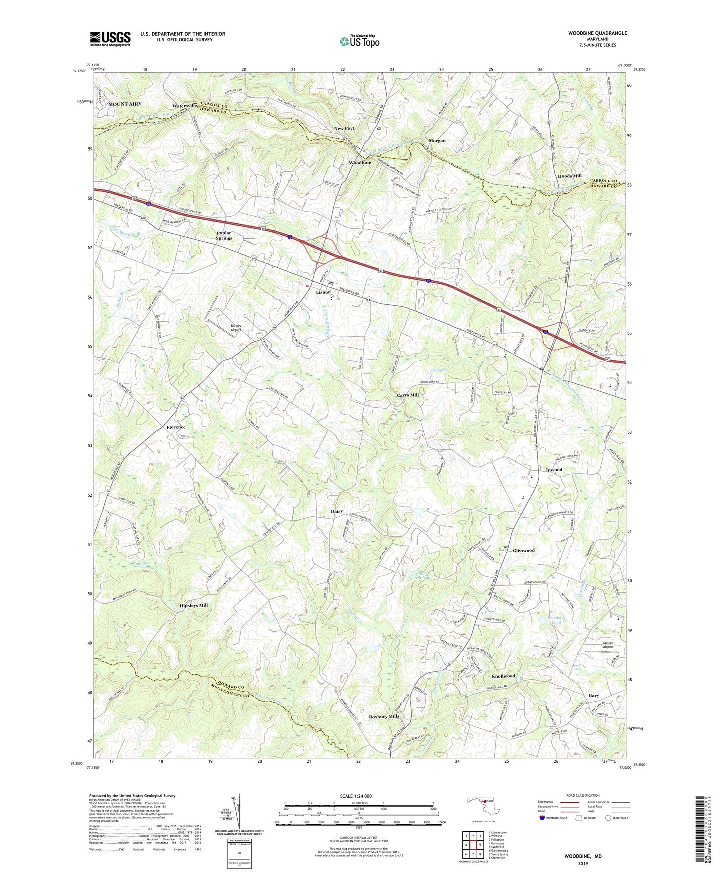
2019 topographic map quadrangle Woodbine in the state of Maryland. Scale: 1:24000. Based on the newly updated USGS 7.5' US Topo map series, this map is in the following counties: Howard, Carroll, Montgomery. The map contains contour data, water features, and other items you are used to seeing on USGS maps, but also has updated roads and other features. This is the next generation of topographic maps. Printed on high-quality waterproof paper with UV fade-resistant inks.
Quads adjacent to this one:
West: Damascus
Northwest: Libertytown
North: Winfield
Northeast: Finksburg
East: Sykesville
Southeast: Clarksville
South: Sandy Spring
Southwest: Gaithersburg
Contains the following named places: Barnes Airport, Brantly, Bushy Park Elementary School, Bushy Park Estates, Cabin Branch, Cabin River Farms, Calvary Evangelical Lutheran Church, Calvary Lutheran Church, Carrs Mill, Carrs Mill Park, Cattail Creek Country Club, Cooksville, Cooksville Post Office, Cool Spring, Countryside, Daisy, Daisy Hill Estates, Daisy Meadows, Daisy United Methodist Church, Daisy Woods, Days End Farm Horse Rescue, Dill, District 4 Lisbon, Dorsey Branch, East Branch Cattail Creek, Eyre View, Ferndale Volunteer Fire Company 34, Flag Marsh Heights, Florence, Florence Farms, Florence Manor, Full Gospel Pentecostal Church, Gary, Gethsemane Baptist Church, Gillis Falls, Glen Burnie Volunteer Fire Company 33, Glenair Airport, Glenelg High School, Glenwood, Glenwood Baptist Church, Glenwood Estates, Glenwood Middle School, Glenwood Park, Glenwood Post Office, Greater Carroll Industrial Park, Green Meadows, Gwenlee Estates, Hay Meadow Branch, Highview Estates, Hipsleys Mill, Hoods Mill, Howard County Library - Glenwood Branch, Howard County Service Center, Inwood, Jaycox, Jennings Chapel United Methodist Church, Jennings Chapel Woods, Justifiable, Kabik Korner, Kimberthy Turf Farms, Knollwood, Lantern Light Farm, Liberty Baptist Church, Linthicum Volunteer Fire Company 32, Lisbon, Lisbon Acres, Lisbon Census Designated Place, Lisbon Christian Church, Lisbon Community Library, Lisbon Elementary School, Lisbon Manor, Lisbon Meadows, Lisbon Park, Lisbon Post Office, Lisbon United Methodist Church, Lisbon Volunteer Fire Company / Howard County Fire and Rescue Station 4, Lisbons Little Creek, Little Cattail Creek, Marley Volunteer Fire Company Company 18, Mill Green, Millys Delight, Morgan, Mount Airy Christian Academy, Mount Gregory School, Mount Gregory United Methodist Church, New Port, Nursery View, Patapsco Overlook, Patuxent River State Park, Poplar Springs, Poplar Springs Park, Poplar Springs United Methodist Church, Providence Methodist Church, Rainbow Estates, Red Lion Inn Estates, Redeeming River Church Woodbine Campus, Riggs Farm Pond, Riggs Farm Pond Dam, Ritz Estates, River Farms, River Plantations, Route 94 Business Center, Rover Mill Estates, Roxbury, Roxbury Mills, Saint Andrews Episcopal Church, Saint James Methodist Episcopal Church, Saint Michaels Catholic Church, Saint Pauls Episcopal Church, School Number 14, School Number 16, School Number 17, Shepherd of the Glen Lutheran Church, Simpson United Methodist Church, The Heritage, Timberleigh Village, Twin Maples, Union Chapel, Vicky Estates, Villa Monticello, Warfield Estates, Warfield Private Airstrip, Warfields Pond, Warfields Pond Park, Watersville, Woodbine, Woodbine Campground, Woodbine Post Office, Woodcamp Farm, Woodmont Academy Elementary School, Woodside Estates, ZIP Codes: 21723, 21738, 21797