MyTopo
Monson Massachusetts US Topo Map
Couldn't load pickup availability
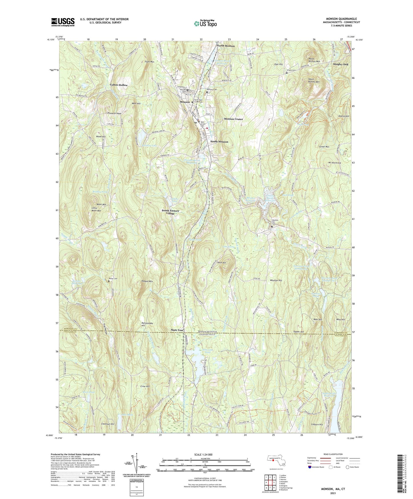
2021 topographic map quadrangle Monson in the states of Massachusetts, Connecticut. Scale: 1:24000. Based on the newly updated USGS 7.5' US Topo map series, this map is in the following counties: Hampden, Tolland. The map contains contour data, water features, and other items you are used to seeing on USGS maps, but also has updated roads and other features. This is the next generation of topographic maps. Printed on high-quality waterproof paper with UV fade-resistant inks.
Quads adjacent to this one:
West: Hampden
Northwest: Ludlow
North: Palmer
Northeast: Warren
East: Wales
Southeast: Westford
South: Stafford Springs
Southwest: Ellington
Contains the following named places: Balloon Port at Dingley Dell, Bear Hill, Bethany Cemetery, Boulder Hill Pond, Boulder Hill Pond Dam, Bradley Pond, Bradway Dam, Bruie Pond, Butler Cemetery, Calkins Pond, Calkins Pond Lower Dam, Calkins Pond Upper Dam, Cedar Swamp, Chestnut Hill, Chicopee Brook Reservoir, Church Manufacturing Company Dam, Colburn Hill, Colton Hollow, Conant Brook, Conant Brook Dam, Conant Brook Reservoir, Crow Hill, Crow Hill Brook, Dean Pond, Dean Pond Dam, Dearth Hill, Delphi Brook, Dingley Dell, Duck Pond, East Hill, Echo Hill Orchards, First Church of Monson, Flynt Mountain, Four Corners, Great Mountain, Grouts Cemetery, Hillside Cemetery, Hillside School, Jennings Pond Dam, Lake Mark, Lake Mark Dam, Lily of the Valley Christian Center, Little Moon Mountain, Lunden Dam, Main Street Cemetery, Memorial Town Hall, Monson, Monson Center Census Designated Place, Monson Fire Department, Monson Free Library and Reading Room, Monson High School, Monson Junior-Senior High School, Monson Medical Center, Monson Police Department, Monson Post Office, Monson Reservoir, Monson Town Hall, Moon Mountain, Moss Hill, Moulton Dam Dropped, Moulton Hill, Moulton Hill Cemetery, Mount Hitchcock, Norcross Number 2 Dam, Norcross Number Four Dam, Norcross Number Three Dam, Norcross Pond Number Four, Norcross Pond Number One, Norcross Pond Number Two, Norcross Ponds, North Main Street Cemetery, North Monson, North Nichols Mountain, Paradise Lake, Paradise Lake Dam, Peaked Mountain, Peck Hill, Pinnacle Creek, Pinnacle Peak, Potash Brook, Quaboag Valley Golf Course, Quarry Hill Community School, Rattlesnake Hill, Sawmill Brook, Smith Pond, South Factory Village, South Monson, South Nichols Mountain, Squire Pond, Staffordville Reservoir, State Line, State Line Pond, Stateline Pond Dam, Town of Monson, Tray Hollow, Tupper Hill, Unitarian Universalist Church, Vinica Brook, West Hill, Wood Hill, Zero Manufacturing Company Dam, ZIP Code: 01057