MyTopo
Tolland Center Massachusetts US Topo Map
Couldn't load pickup availability
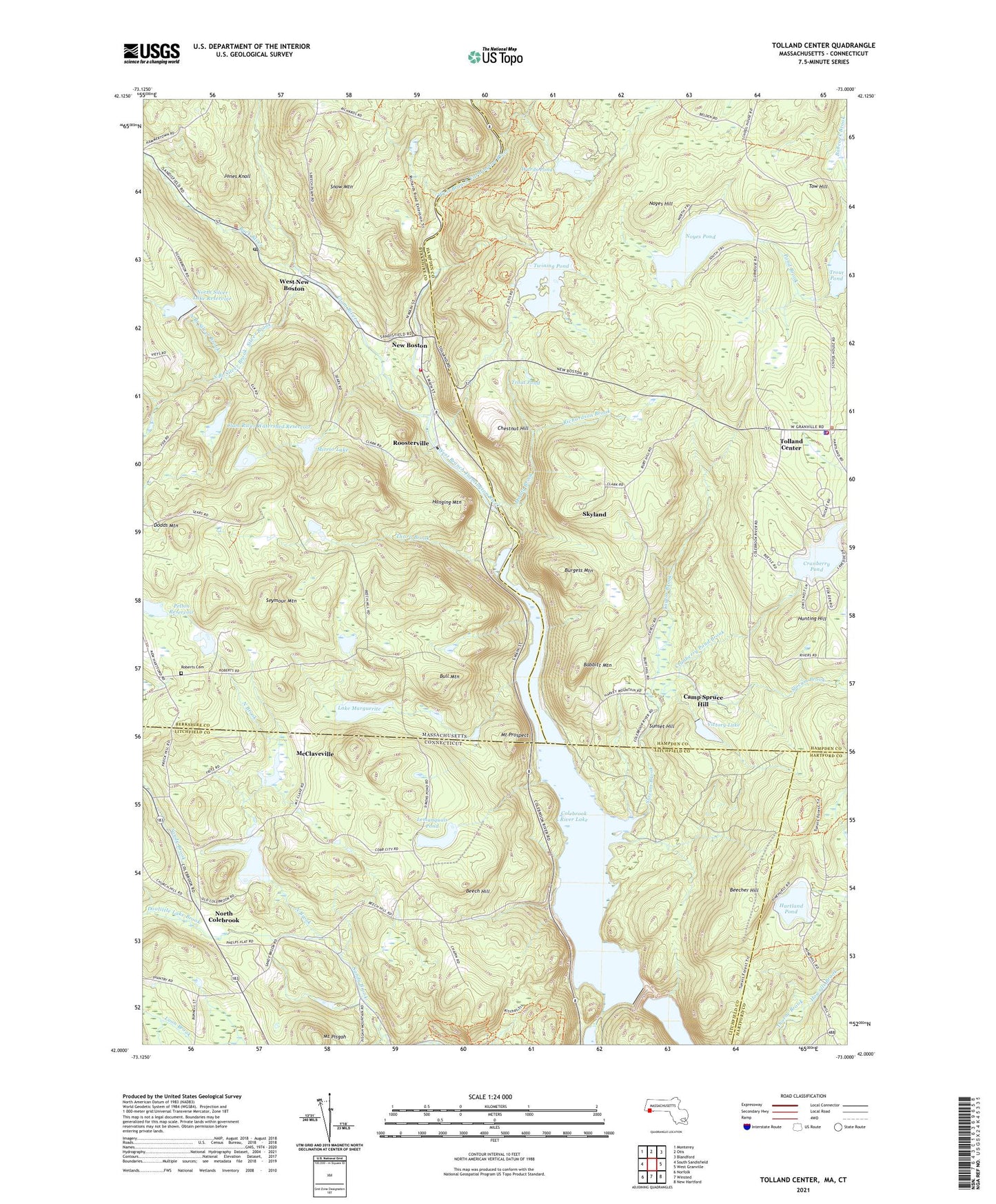
2021 topographic map quadrangle Tolland Center in the states of Massachusetts, Connecticut. Scale: 1:24000. Based on the newly updated USGS 7.5' US Topo map series, this map is in the following counties: Berkshire, Hampden, Litchfield, Hartford. The map contains contour data, water features, and other items you are used to seeing on USGS maps, but also has updated roads and other features. This is the next generation of topographic maps. Printed on high-quality waterproof paper with UV fade-resistant inks.
Quads adjacent to this one:
West: South Sandisfield
Northwest: Monterey
North: Otis
Northeast: Blandford
East: West Granville
Southeast: New Hartford
South: Winsted
Southwest: Norfolk
Contains the following named places: Babbitt Mountain, Beech Hill, Beecher Hill, Buck River, Bull Mountain, Burgess Mountain, Camp Jewell, Camp Spruce Hill, Center Brook, Chestnut Hill, Clam River, Clam River Watershed Dam, Clam River Watershed Reservoir, Colebrook River Dam, Colebrook River Lake, Colebrook Town Garage, Cranberry Pond, Cranberry Pond Brook, Cranberry Pond Dam, Dodds Mountain, Doolittle Lake Brook, Free Quarter, Haley Brook, Hanging Mountain, Hartland Pond, Howells Brook, Hunting Hill, Jones Knoll, Lake Marguerite, Lake Triangle, Lake Triangle Dam, Lemanquais Pond, Lemanquais Pond Dam, Lost Wilderness Lake, Lost Wilderness Lake Northern Dam, Lost Wilderness Lake Southern Dam, McClaveville, Mirror Lake, Mirror Lake Dam, Moody Brook, Mount Pisgah, Mount Prospect, New Boston, North Branch Silver Brook, North Brook, North Colebrook, North Silver Lake Dam, North Silver Lake Reservoir, Noyes Hill, Noyes Pond, Noyes Pond Dam, Pelton Dam, Pelton Reservoir, Red Rock Schoolhouse, Richardson Brook, Roberts Cemetery, Roosterville, Sandisfield Fire Department Station 1, Sandisfield Police Department, Sandisfield Post Office, Sandisfield School, Seymour Mountain, Silver Brook, Skyland, Slocum Brook, Snow Mountain, South Branch Silver Brook, Sunset Hill, Taylor Brook, Thorp Brook, Tolland Center, Tolland Center Town Hall, Tolland Fire Department, Tolland Police Department, Tolland Public Library, Tow Hill, Town of Colebrook, Town of Sandisfield, Town of Tolland, Trout Pond, Twining Pond, Victory Lake, Victory Lake Dam, Wards Pond, Wards Pond Dam, West New Boston, West New Boston Post Office, West New Boston Town Hall, ZIP Codes: 01255, 06021