MyTopo
Austin Montana US Topo Map
Couldn't load pickup availability
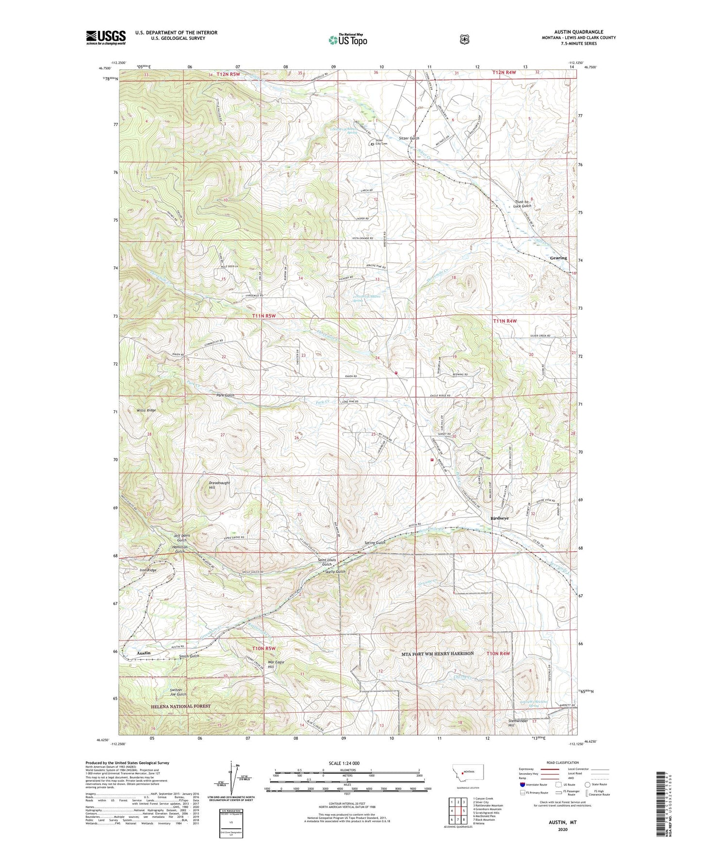
2020 topographic map quadrangle Austin in the state of Montana. Scale: 1:24000. Based on the newly updated USGS 7.5' US Topo map series, this map is in the following counties: Lewis and Clark. The map contains contour data, water features, and other items you are used to seeing on USGS maps, but also has updated roads and other features. This is the next generation of topographic maps. Printed on high-quality waterproof paper with UV fade-resistant inks.
Quads adjacent to this one:
West: Greenhorn Mountain
Northwest: Canyon Creek
North: Silver City
Northeast: Rattlesnake Mountain
East: Scratchgravel Hills
Southeast: Helena
South: Black Mountain
Southwest: MacDonald Pass
Contains the following named places: 10N04W05AADB01 Well, 10N04W17BAAD01 Spring, 10N05W03ABCB01 Well, 10N05W10ADBB01 Well, 11N04W06DCCC01 Well, 11N04W20BBCD01 Well, 11N04W20DCBD01 Well, 11N04W30ACBC01 Well, 11N04W32ADCB01 Well, 11N05W13CBAA01 Spring, 11N05W13CBBD01 Spring, 11N05W14ADAA01 Well, 11N05W14CABC01 Well, 11N05W15DBAA01 Well, 11N05W21AABD01 Well, 11N05W23CBAA01 Well, 11N05W25BCCC01 Well, 11N05W35BCCB01 Well, Austin, Austin Post Office, Austin School, Betty Anne Mine, Birdseye, Birdseye Post Office, Birdseye Rural Fire Department Station Number 1, Birdseye School, Bulls Head Mine, Cruse, Cyanide, Dreadnaught Hill, Dreadnaught/Paymaster Mine, Duffy, Gearing, Granite Creek, Granite Creek Mine, Green Bird Mine, Greenhorn Creek, Greenhorn Post Office, Hamilton Gulch, Jeff Davis Gulch, Jeff Davis Gulch Mine, King Tut Mine, NE NE Section 33 Mine, NE SE Section 16 Mine, NE SW Section 6 Mine, Park Creek, Park Gulch, Rattlesnake Creek, Saint Louis Gulch, SE NE Section 3 Mine, SE NW Section 18 Mine, SE SW Section 27 Mine, Silver City Airport, Silver City Cemetery, Silver Creek Placer Mine, Sitzer Gulch, Sitzer Gulch Mine, Skelly Gulch, Smith Gulch, Spring Gulch, Spring Gulch Mine, Stemwinder Hill, SW NW Section 6 Mine, SW SE Section 18 Mine, Switzer Joe Gulch, Three Mile Reservoir Dam, Threemile Creek, Trust-to-Luck Gulch, War Eagle, War Eagle Hill, Willit Ridge