MyTopo
Crawford Notch New Hampshire US Topo Map
Couldn't load pickup availability
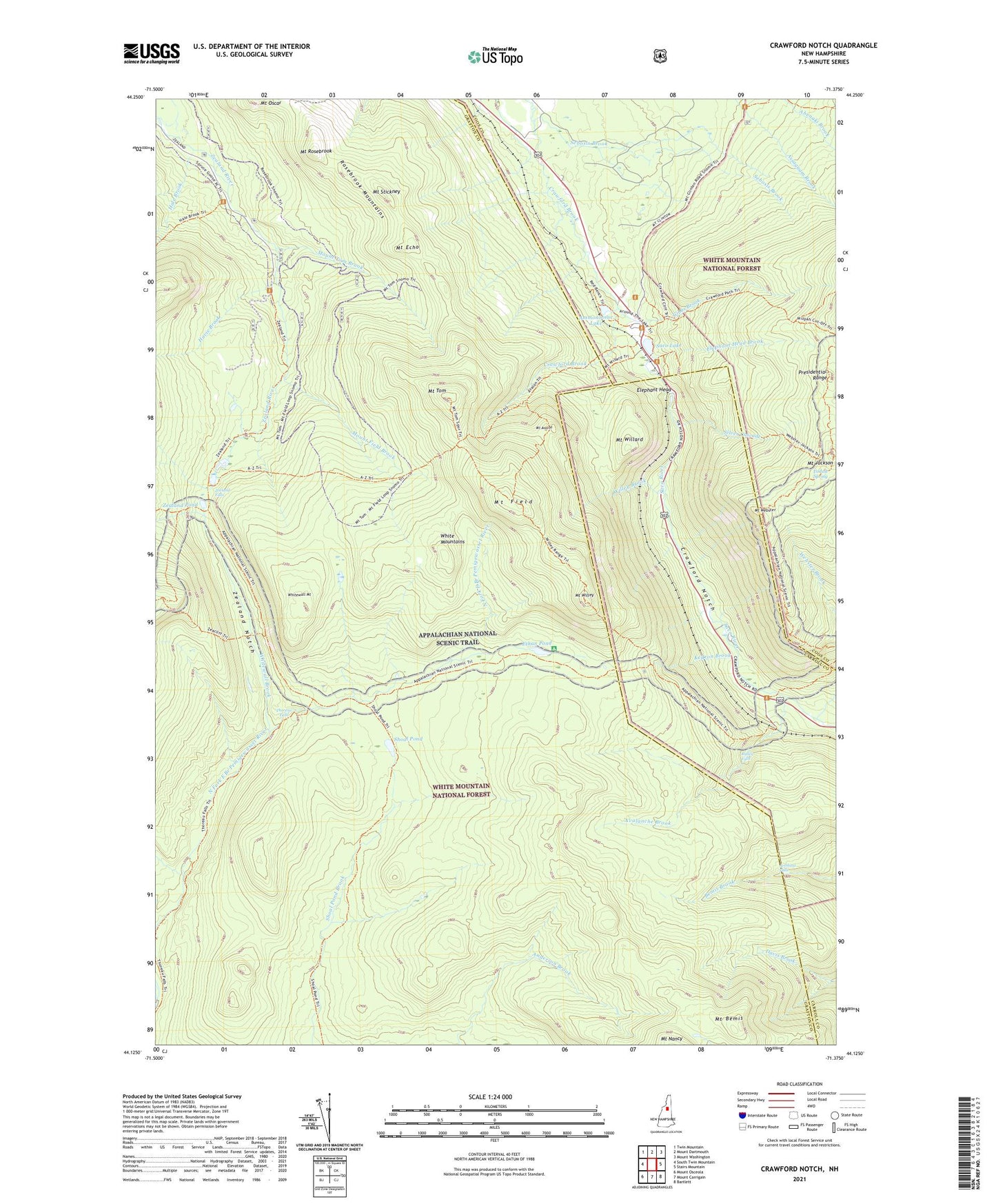
2021 topographic map quadrangle Crawford Notch in the state of New Hampshire. Scale: 1:24000. Based on the newly updated USGS 7.5' US Topo map series, this map is in the following counties: Grafton, Coos, Carroll. The map contains contour data, water features, and other items you are used to seeing on USGS maps, but also has updated roads and other features. This is the next generation of topographic maps. Printed on high-quality waterproof paper with UV fade-resistant inks.
Quads adjacent to this one:
West: South Twin Mountain
Northwest: Twin Mountain
North: Mount Dartmouth
Northeast: Mount Washington
East: Stairs Mountain
Southeast: Bartlett
South: Mount Carrigain
Southwest: Mount Osceola
Contains the following named places: Ammonoosuc Lake, Arethusa Falls, Avalanche Brook, Avalon Trail, A-Z Trail, Beans Grant, Crawford Brook, Crawford House, Crawford Notch, Crawford Notch State Reservation, Elephant Head, Elephant Head Brook, Ethan Pond, Ethan Pond Shelter, Ethan Pond Trail, Flume Cascade, Gibbs Brook, Gibbs Brook Scenic Area, Hale Brook, Havie Brook, Jumping Brook, Kedron Brook, Lincoln Woods Scenic Area, Mount Avalon, Mount Avalon Trail, Mount Bemis, Mount Echo, Mount Field, Mount Field Brook, Mount Jackson, Mount Rosebrook, Mount Rosebrook Trail, Mount Stickney, Mount Tom, Mount Tom Brook, Mount Webster, Mount Webster Trail, Mount Willard, Mount Willey, Ripley Falls, Rosebrook Mountains, Saco Lake, Shoal Pond, Shoal Pond Trail, Silver Cascade, Stillwater By-Pass, Thoreau Falls, Thoreau Falls Trail, Tisdale Spring, Webster Brook, Webster Cliff Trail, Webster Trail, White Mountain National Forest, Whitewall Brook, Whitewall Mount, Wiley Range Trail, Willey Brook, Willey House, Willey House Camps, Zeacliff Trail, Zealand Falls, Zealand Notch, Zealand Pond, Zealand Trail, Zealand Valley Trail