MyTopo
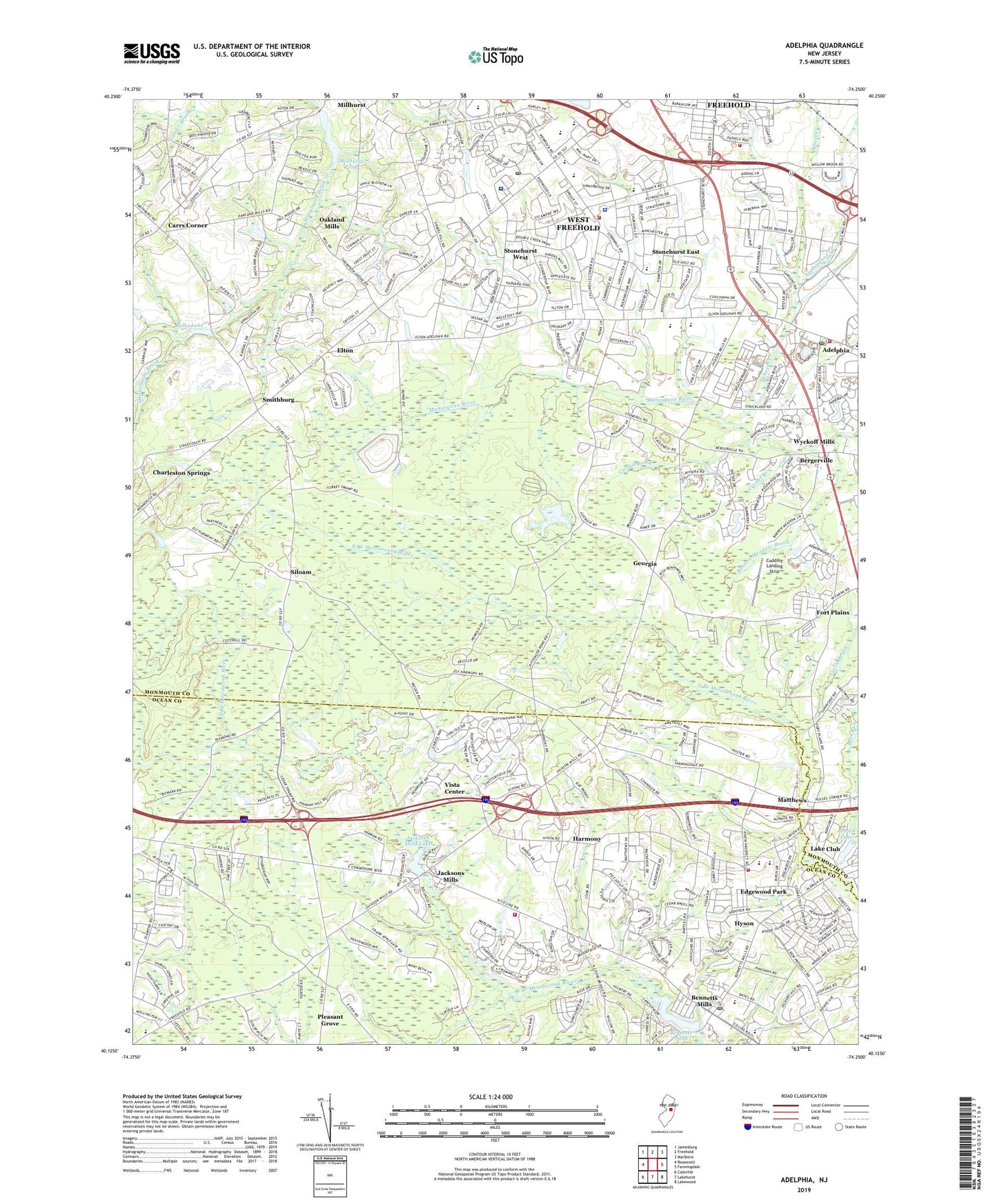
Adelphia New Jersey US Topo Map
Couldn't load pickup availability
2019 topographic map quadrangle Adelphia in the state of New Jersey. Scale: 1:24000. Based on the newly updated USGS 7.5' US Topo map series, this map is in the following counties: Monmouth, Ocean. The map contains contour data, water features, and other items you are used to seeing on USGS maps, but also has updated roads and other features. This is the next generation of topographic maps. Printed on high-quality waterproof paper with UV fade-resistant inks.
Quads adjacent to this one:
West: Roosevelt
Northwest: Jamesburg
North: Freehold
Northeast: Marlboro
East: Farmingdale
Southeast: Lakewood
South: Lakehurst
Southwest: Cassville
Contains the following named places: Adelphia, Adelphia Post Office, Aldrich Lake, Aldrich Lake Dam, Applegates Creek, Bannen Meadow Brook, Bass Run, Bennetts Mills, Bennetts Mills Dam, Bennetts Pond, Bergerville, Brookdale Community College Western Monmouth Campus, Bulks Lake, Burkes Creek, Carrs Corner, Cattail Brook, Centra State Medical Center, Centra State Medical Center Heliport, Central Jersey Bank Heliport, Centrastate Medical Center, Charleston Springs, Charleston Springs Golf Course, Clifton T Barkalow Elementary School, Crawford Rodriquez Elementary School, Crest Fruit Farm, Cricket Creek, Cuddihy Landing Strip, Debois Creek, East Fork Turtle Brook, Edgewood Park, Ekdahl Airport, Elton, Fort Plains, Freehold Post Office, Freehold Township Early Childhood Learning Center School, Freehold Township Fire Commission, Freehold Township Fire District 2 East Freehold Fire Company Daniels Way Annex, Freehold Township High School, Freehold Township Independent Fire Company 1, Freehold Township Police Department, Georgia, Goddard School, Greentree Park, Harmony, Howard C Johnson Elementary School, Howell Township Fire District 2 Howell Fire Company Adelphia Station 1, Hyson, Jackson Mills Volunteer Fire Company Station 54, Jackson Post Office, Jackson Township Volunteer Fire Company, Jacksons Mills, Jacksons Mills Dam, Jacksons Mills Lake, Laura Donovan Elementary School, Liberty Oak Park, Long Brook, Marshall W Errickson Elementary School, Matthews, Metedeconk National Golf Club, Millhurst Dam, Millhurst Pond, New Jersey Bell CDC 11 Heliport, Newbold Island Heliport, Oakland Mills, Oakwood, Progress Industrial Park, Providence Christian Academy School, Ridge Creek, Saint Aloysius School, Siloam, Siloam United Methodist Church, Small Branch, Smithburg, Snipe Creek, Stonehurst East, Stonehurst Park, Stonehurst West, Township of Freehold, Turkey Swamp Park, Turkey Swamp Wildlife Management Area, Turtle Brook, Vista Center, Vista Center Census Designated Place, West Fork Ridge Creek, West Fork Turtle Brook, West Freehold, West Freehold Census Designated Place, West Freehold Elementary School, Woodcrest Park, WQHF-FM (Freehold Township), Wyckoff Mills, ZIP Code: 07728