
MyTopo
Alexandria Bay New York US Topo Map
Couldn't load pickup availability
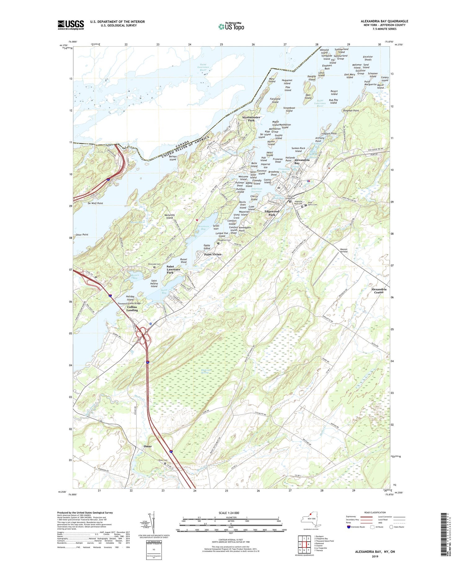
2019 topographic map quadrangle Alexandria Bay in the state of New York. Scale: 1:24000. Based on the newly updated USGS 7.5' US Topo map series, this map is in the following counties: Jefferson. The map contains contour data, water features, and other items you are used to seeing on USGS maps, but also has updated roads and other features. This is the next generation of topographic maps. Printed on high-quality waterproof paper with UV fade-resistant inks.
Quads adjacent to this one:
West: Thousand Island Park
North: Rockport
Northeast: Chippewa Bay
East: Redwood
Southeast: Theresa
South: La Fargeville
Southwest: Clayton
Contains the following named places: Alexandria Bay, Alexandria Bay Baptist Church, Alexandria Bay Harbor, Alexandria Bay High School, Alexandria Bay Post Office, Alexandria Bay Village Fire Department, Alexandria Bay Village Police Department, Alexandria Bay Wastewater Treatment Plant, Alexandria Center, American Narrows, Anthony Point, Baileys Island, Baileys Schoolhouse, Barnett Marsh, Bay Drive-In, Bella Vista, Belle Island, Black Ash Swamp, Boldt Castle, Bonnie Castle Yacht Basin, Broadway Shoal, Brown Bay, Canary Island, Carnegie Bay, Casino Island, Central Schools, Cherry Island, Church Street Cemetery, Collins Landing, Collins Landing Southbound Rest Area, Comfort Island, Comfort Island Shoal, Comfort Shoal Lighthouse, Cranberry Creek Wildlife Management Area, Crossmon Bay, Crossmon House, Cuba Island, De Wolf Point, Deer Island, Densmore Bay, Densmore Bay Church, Devils Oven Island, Dingman Point, Douglas Island, East Mary Island, Edgewood Park, Edward John Noble Hospital, Elephant Back, Excelsior Group, Excelsior Shoals, Fairyland Island, Fineview Post Office, First Methodist Episcopal Church, Florence Island, Friendly Island, Fronenac Shoal, Godfreys Corner, Grass Point State Park, Greens Bay, Greens Creek, Gussey Island, Gypsy Island, Harbor Island, Harbor Island Light, Heart Island, Highland Park Cemetery, Holiday Island, Holland Library, Hollands Point, Houghton Cemetery, Hub Island, Huguenot Island, Idlewild Island, Imperial Isle, Ina Island, Iroquois Point, Keewaydin Marina, Keewaydin Point, Keewaydin Point State Park, Kipp Island, Lake of the Isles, Leading Light, Little Watch Island, Longue Vue Island, Lotus Island, MacSherry Library, Malomar Island, Mance Marine Basin, Manhattan Group, Manhattan Island, Maple Island, Marsh Island, Mary Island, Mary Island State Park, Maxson Airfield, Meadow Lane Mobile Home Park, Moore Landing, NCH Heliport, New York State Police Troop D Zone 3 Alexandria Bay Station, Nobby Island, Omar, Omar Cemetery, Otter Creek, Otter Creek Bay, Otter Point, Pike Island, Pine Tree Point Club, Pinehurst Resort, Point Marguerite, Point Vivian, Pullman Island, Pullman Shoal, Pullman Shoal Lighthouse, R. T. Clayton Vessel Traffic Control, Reformed Church of the Thousand Isles, Resort Island, Riverside Cemetery, Rob Roy Island, Russel Shoal, Saint Cyril's Cemetery, Saint Cyril's Roman Catholic Church, Saint Elmo Island, Saint Helena Island, Saint Lawrence Episcopal Church, Saint Lawrence Park, Sand Island, School Number 13, School Number 19, Schooner Island, Seven Isles, Ski Island, Steamboat Island, Stony Crest, Summerland Group, Summerland Island, Sunken Rock Island, Sunken Rock Lighthouse, Sunken Rock Shoal Lighthouse, Sunnyside Island, Swan Bay, Swan Bay Estates Mobile Home Park, Swan Bay Marina, Thousand Islands, Thousand Islands Bridge, Thousand Islands Country Club, Thousand Islands Drive-In, Town of Alexandria, Village of Alexandria Bay, Wagoners Marina, Wauwinel Island, Welcome Island, Wellesley Island Volunteer Fire Department Densmore Station, Wellesley Island Volunteer Fire Department Thousand Island Park, Wells Island Lighthouse, Westminster Park, ZIP Code: 13607


