
MyTopo
Amityville New York US Topo Map
Couldn't load pickup availability
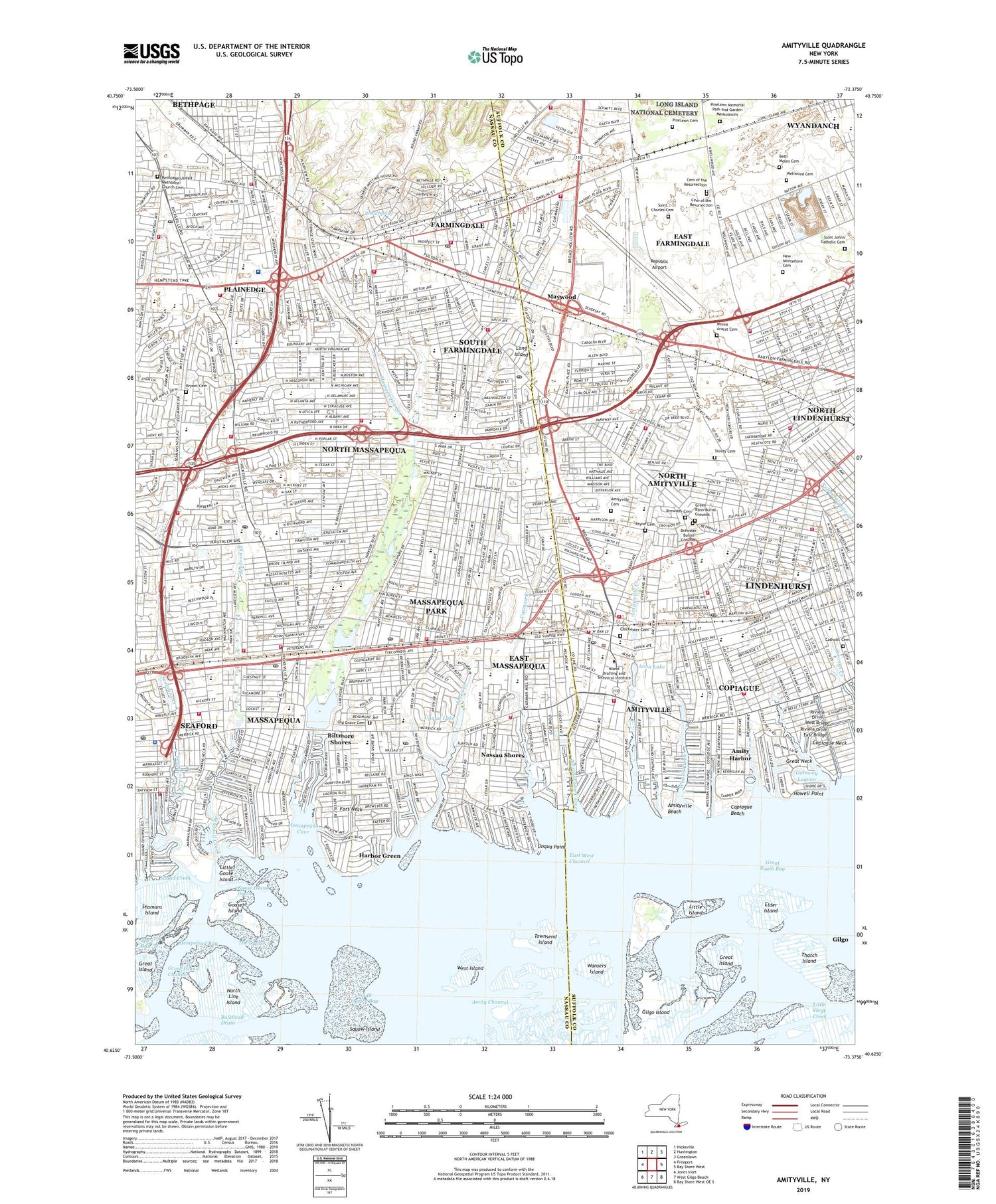
2019 topographic map quadrangle Amityville in the state of New York. Scale: 1:24000. Based on the newly updated USGS 7.5' US Topo map series, this map is in the following counties: Nassau, Suffolk. The map contains contour data, water features, and other items you are used to seeing on USGS maps, but also has updated roads and other features. This is the next generation of topographic maps. Printed on high-quality waterproof paper with UV fade-resistant inks.
Quads adjacent to this one:
West: Freeport
Northwest: Hicksville
North: Huntington
Northeast: Greenlawn
East: Bay Shore West
Southeast: Bay Shore West OE S
South: West Gilgo Beach
Southwest: Jones Inlet
Contains the following named places: Albany Avenue Elementary School, Albany Avenue School, Amity Channel, Amity Harbor, Amityville, Amityville Beach, Amityville Cemetery, Amityville Creek, Amityville Memorial High School, Amityville Station, Avon Lake, Babylon Marsh State Tidal Wetlands, Babylon North U Bypass Landfill, Baldwin Drive School, Berner Middle School, Beth Moses Cemetery, Bethpage, Bethpage Census Designated Place, Bethpage State Park, Bethpage State Park Golf Course, Bethpage Station, Bethpage United Methodist Church Cemetery, Biltmore Shores, Biltmore Shores Golf Course, Birch Lane Elementary School, Brady Park, Bread Spring, Brewster Burial Grounds, Brewster Cemetery, Brunswick General Hospital, Brunswick Hospital Center, Brunswick Hospital Heliport, Bryant Cemetery, Bulkhead Drain, Canal 10, Canal 6, Canal 7, Canal 8, Canal 9, Carman Creek, Carman Road School, Catholic Cemetery, Cedar Creek, Cemetery of the Resurrection, Central Boulevard Elementary School, Chichester Cemetery, Colonial Springs Golf Course, Copiague, Copiague Beach, Copiague Census Designated Place, Copiague Harbor, Copiague Middle School, Copiague Neck, Copiague Station, Deauville Gardens Elementary School, E W Allen Town Park, East Broadway School, East Farmingdale, East Farmingdale Census Designated Place, East Farmingdale Memorial School, East Lake Elementary School, East Massapequa, East Massapequa Census Designated Place, Eastplain School, Edmund W Miles Middle School, Elder Island, Fairfield Elementary School, Farmingdale, Farmingdale Army Air Field, Farmingdale High School, Farmingdale Station, Firemens Memorial Park, Fitzmaurie Field, Fort Neck, Frontier Park, Gateway Lagoon, Gildersleeve Park For Mobile Homes, Gilgo Census Designated Place, Gilgo Island, Goose Island, Goose Island Drain, Grand Canal, Grand Lagoon, Great Island, Great Island Channel, Great Neck, Great Neck Creek, Great Neck Road Elementary School, Green Bunn Burial Grounds, Grumman-Bethpage Airfield, Harbor Green, Hawthorn School, Howell Creek, Howell Point, Howitt Junior High School, Island Trees High School, Island Trees Middle School, James A Caples Memorial Park, Jefferson Canal, John F Kennedy Middle School, John J Burns Park, Johnny All Weather Drive-In, Jones Creek, Kellum Street School, LaSalle Regional School - Bethpage Campus, Little Goose Island, Little Island, Lockhart Elementary School, Main Street School, Maria Regina School, Marjorie Post Park, Massapequa, Massapequa Census Designated Place, Massapequa Cove, Massapequa Creek, Massapequa Drive-In, Massapequa High School, Massapequa Lake, Massapequa Park, Massapequa Park Station, Massapequa Preserve, Massapequa Station, Maxine Postal Memorial Park, Maywood, McKenna Elementary School, Memorial Triangle, Michel Park, Milton L Olive Middle School, Mount Ararat Cemetery, Narraskatuck Creek, Nassau Shores, Nassau Shores Golf Course, Nautical Park, New Montefiore Cemetery, New York State Poor Farm, Nike Site NY-24C, Nike Site NY-24L, North Amityville, North Amityville Census Designated Place, North Canal, North Lindenhurst, North Lindenhurst Census Designated Place, North Line Island, North Massapequa, North Massapequa Census Designated Place, Northeast School, Northside Elementary School, Northwest Elementary School, Old Grace Cemetery, Old Town Cemetery, Our Lady of Lourdes School, Park Avenue School, Parkside Junior High School, Parkway Oaks School, Payne Cemetery, Peninsula Golf Club, Peterkin Park, Petteanger Island State Tidal Wetlands, Picken School, Pinehusrt Park, Pinelawn Cemetery, Pinelawn Memorial Park and Garden Mausoleums, Pinelawn Station, Plainedge, Plainedge Census Designated Place, Plainedge High School, Plainedge Middle School, Polytechnic Institute of Brooklyn at Farmingdale, Port Neck Meadow, Price Plaza Shopping Center, Queen of the Rosary Academy, Republic Airport, Riviera Drive East Bridge, Riviera Drive West Bridge, Ronek Park, Roosevelt Canal, Saint Charles Cemetery, Saint James School, Saint John Baptist De LaSalle Regional School, Saint John's Catholic Cemetery, Saint Joseph Hospital, Saint Martin of Tours School, Saint Rose of Lima School, Saint William the Abbot School, Saltzman East Memorial Elementary School, Schmidt Canal, School Street School, Seafood Creek, Seaford, Seaford Census Designated Place, Seaford Station, Seamans Creek, Seamans Island, Seamans Neck Park, South Bay Inlet, South Farmingdale, South Farmingdale Census Designated Place, South Oaks Hospital, South Oyster Bay, Squaw Island, Sunrise Lagoon, Sylvia Packard Middle School, Tackapausha Preserve, Tanner Park, Tern Canal, Thatch Island, The Drain, The Run, Townsend Island, Trinity Cemetery, Unqua - Corinthian Yacht Club, Unqua Lake, Unqua Point, Venetta Lagoon, Village of Amityville, Village of Farmingdale, Village of Massapequa Park, Walter G O'Connell Copiague High School, Wansers Island, Washington Avenue Park, Wellwood Avenue Bridge, Wellwood Cemetery, West Amityville, West Island, Westfield Sunrise Shopping Center, Wilson Canal, Woods Creek, Zahns Airport, ZIP Codes: 11701, 11714, 11726, 11735, 11758, 11762, 11783


