MyTopo
Avoca Pennsylvania US Topo Map
Couldn't load pickup availability
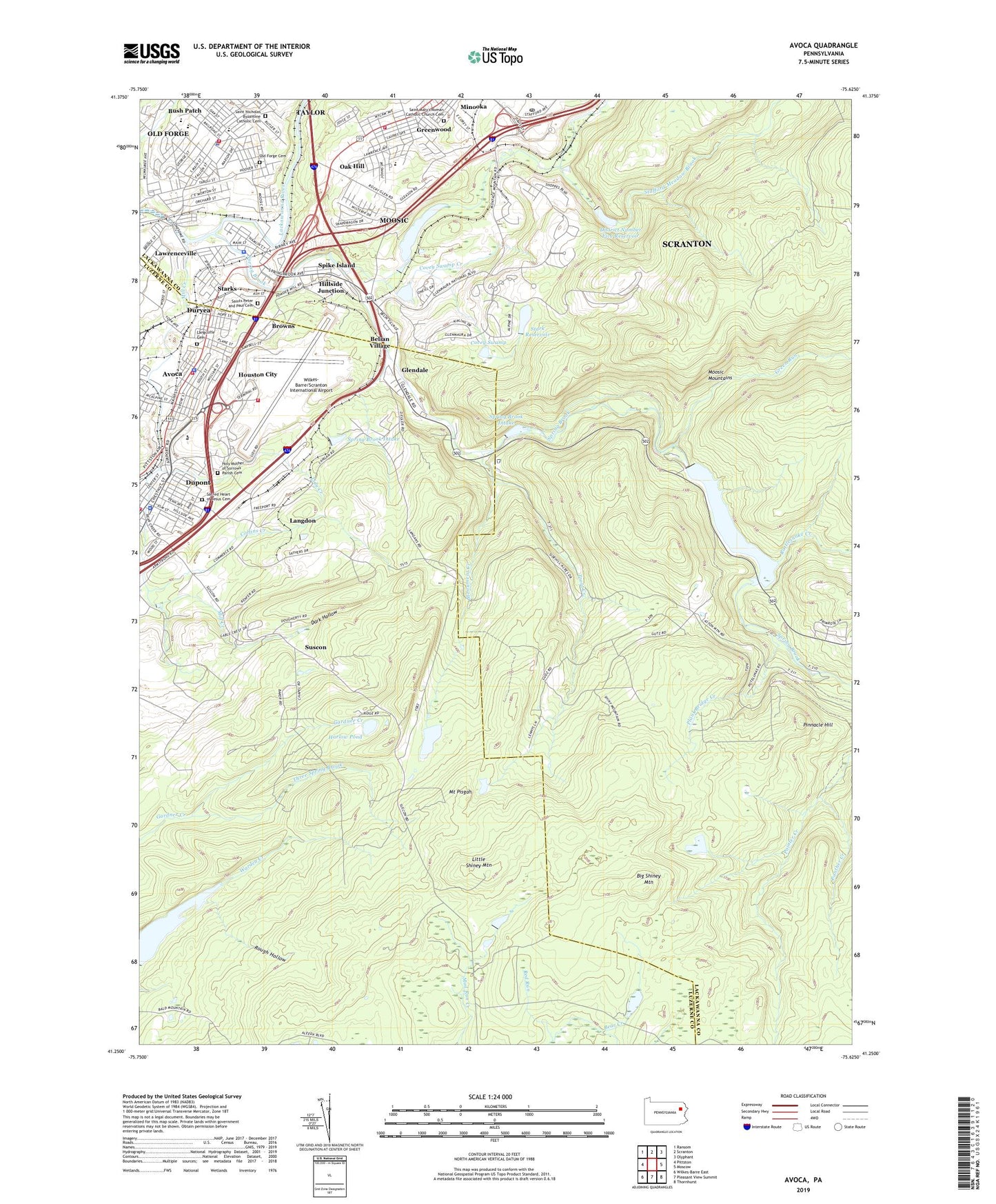
2019 topographic map quadrangle Avoca in the state of Pennsylvania. Scale: 1:24000. Based on the newly updated USGS 7.5' US Topo map series, this map is in the following counties: Lackawanna, Luzerne. The map contains contour data, water features, and other items you are used to seeing on USGS maps, but also has updated roads and other features. This is the next generation of topographic maps. Printed on high-quality waterproof paper with UV fade-resistant inks.
Quads adjacent to this one:
West: Pittston
Northwest: Ransom
North: Scranton
Northeast: Olyphant
East: Moscow
Southeast: Thornhurst
South: Pleasant View Summit
Southwest: Wilkes-Barre East
Contains the following named places: Avoca, Avoca Ambulance Station 12, Avoca Boro Police Department, Avoca Hose Company Station 12, Barbertown, Belian Village, Big Shiney Mountain, Borough of Avoca, Borough of Dupont, Borough of Moosic, Borough of Old Forge, Brown Breaker, Browns, Brownville Breaker, Bush Patch, Carbon Hill Breaker, Carbon Hill Shaft, Central Breaker, Chittenden Shaft, Collins Creek, Covey Dam, Covey Swamp, Covey Swamp Creek, Dark Hollow, District Number Five Reservoir, Dry Valley Run, Dupont, Dupont Borough Police Department, Dupont Connection, Dupont Volunteer Fire Department Station 125, Duryea, Elmwood Shaft, Ghost Town in the Glen, Glendale, Glenwood Lake Dam, Green Run, Greenwood, Greenwood Fire Department Station 98, Harlow Pond, Hillside Colliery, Hillside Junction, Holy Mother of Sorrows Parish Cemetery, Houston City, Katydid Colliery, Lackawanna Station, Langcliffe Cemetery, Langdon, Law Shaft, Lawrence Hose Company Old Forge Station 93 - 1, Lawrenceville, Lidy Creek, Little Shiney Mountain, Mill Creek, Mill Creek Dam, Mill Creek Reservoir, Montage Ski Area, Monument Creek, Moosic, Moosic Industrial Park, Moosic Police Department, Moosic Powder Works, Mount Pisgah, Nesbitt Dam, Nesbitt Reservoir, New Rall Dam, Oak Hill, Oakhill Colliery, Old Forge, Old Forge Ambulance and Rescue Station 93, Old Forge Borough Police Station, Old Forge Breaker, Old Forge Cemetery, Old Forge Hose and Engine Company 93, Old Forge Junior Senior High School, Old Forge Number 2 Shaft, Ontario Colliery, PA-5 Dam, Painter Creek, Pinnacle Hill, Plank Bridge Creek, Powder Mill Shaft, Rattlesnake Creek, Red Run, Rocky Glen Dam, Rocky Glenn Pond, Roosevelt School, Rough Hollow, Sacred Heart of Jesus Cemetery, Saint Mary's Roman Catholic Church Cemetery, Saint Marys School, Saint Nicholas Byzantine Catholic Cemetery, Saints Peter and Paul Cemetery, Scranton Post Office, Spike Island, Spring Brook, Spring Brook Colliery, Spring Brook Intake, Spring Brook Intake Dam, Stark Dam, Stark Reservoir, Starks, Suscon, Suscon Station, Three Spring Brook, Township of Pittston, Trout Creek, Virginia Station, Warden Creek, Whip Poor Will Colliery, Wilkes - Barre / Scranton International Airport Fire Department, Wilkes-Barre/Scranton International Airport, ZIP Codes: 18507, 18640, 18641