MyTopo
Blue Ridge Summit Pennsylvania US Topo Map
Couldn't load pickup availability
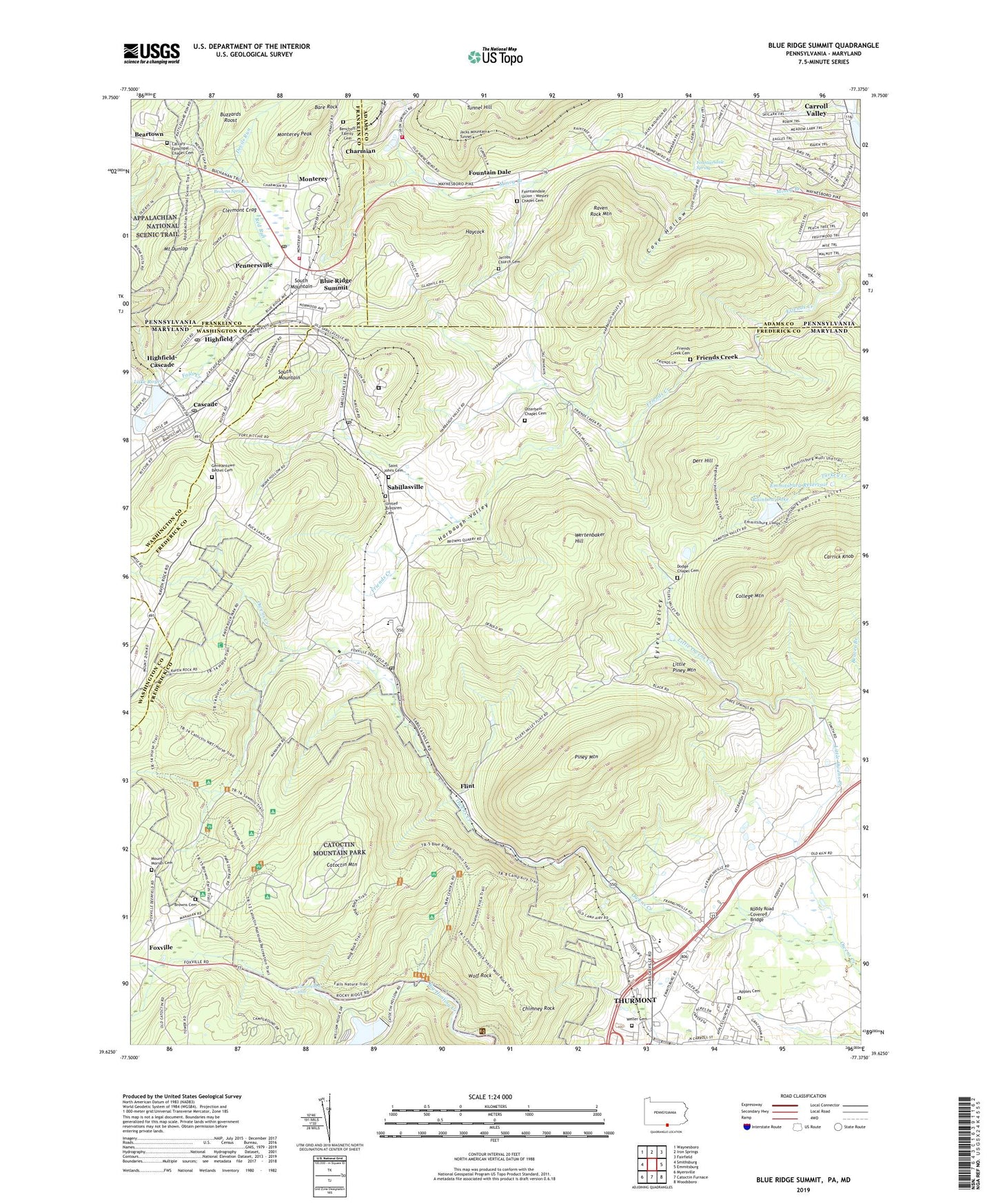
2019 topographic map quadrangle Blue Ridge Summit in the states of Maryland, Pennsylvania. Scale: 1:24000. Based on the newly updated USGS 7.5' US Topo map series, this map is in the following counties: Adams, Frederick, Franklin, Washington. The map contains contour data, water features, and other items you are used to seeing on USGS maps, but also has updated roads and other features. This is the next generation of topographic maps. Printed on high-quality waterproof paper with UV fade-resistant inks.
Quads adjacent to this one:
West: Smithsburg
Northwest: Waynesboro
North: Iron Springs
Northeast: Fairfield
East: Emmitsburg
Southeast: Woodsboro
South: Catoctin Furnace
Southwest: Myersville
Contains the following named places: Apples Cemetery, Apples Church, Bare Rock, Beartown Church, Bellemere Estates, Benchoff Family Cemetery, Blacks Hilltop Orchard, Blue Ridge Fire and Rescue Company 4, Blue Ridge Lookout Tower, Blue Ridge Station, Blue Ridge Summit, Blue Ridge Summit Census Designated Place, Blue Ridge Summit Overlook, Blue Ridge Summit Post Office, Borough of Carroll Valley, Browns Cemetery, Browns Spring, Browns Store, Buena Vista Spring Station, Buzzards Roost, Calvary Episcopal Chapel Cemetery, Camp 1, Camp 2, Camp 3, Camp Airy, Camp Greentop Historic District, Camp Louise, Camp Misty Mount Historic District, Camp Peniel, Carrick Knob, Carroll Valley, Cascade, Cascade Elementary School, Cascade Post Office, Catoctin Breeze Vineyard, Catoctin Heights, Catoctin High School, Catoctin Highlands, Catoctin Mountain, Catoctin Mountain Orchard, Catoctin Mountain Park, Charmian, Chimney Rock, Clermont Crag, College Mountain, Colonial Heights, Cove Hollow, Cunningham Falls, Cunningham Falls Nature Trail, Deerfield United Methodist Church, Derr Hill, Devils Run, Distant View, District 10 Hauvers, District 15 Thurmont, Dodge Chapel Cemetery, Emmitsburg Dam, Emmitsburg Reservoir, Eyeler, Eyler Road Recreation Area, Eylers Valley, Eylers Valley Chapel, Flanagan Orchards, Flint, Fountain Dale, Fountaindale Spring, Fountaindale Union Cemetery, Fountaindale Volunteer Fire Company, Fountaindale Volunteer Fire Company Station 3, Foxville, Foxville Ranger Station, Foxville School, Friends Creek, Friends Creek Cemetery, Friends Creek Church of God, Friendship, Funkhouser Mill, Germantown Church, Germantown Church of God Cemetery, Harbaugh Valley, Hauver Branch, Haycock, High Rock Nature Trail, Highfield, Highfield Post Office, Highfield-Cascade Census Designated Place, Hunting Creek Dam, Hunting Creek Lake, Jacks Mountain Tunnel, Jacobs Church, Jacobs Church Cemetery, Lake Royer, Lantz, Lantz Post Office, Little Owens Creek, Little Piney Mountain, Lost Valley, Lower Lake Royer Dam, Manahan Ranch Estates, Monterey, Monterey Peak, Monterey School, Mount Dunlop, Mount Maria Church, Mount Moriah Cemetery, Otterbein Chapel Cemetery, Otterbein Chapel United Brethren Church, Owens Creek Camp, Pennersville, Piney Mountain, Quirauk School, Rainbow Lake, Raven Rock Mountain, Ridgeview, Roddy, Roddy Road Covered Bridge, Roddy Road Park, Round Meadow Camp Number 4, Rowland Hill, Sabillasville, Sabillasville Census Designated Place, Sabillasville Elementary School, Sabillasville Post Office, Saint John United Methodist Church, Saint Johns Cemetery, Saint Mark Lutheran Church, Saint Stephens United Church of Christ, Scenic View Orchards, Seymour B Cooper Memorial Wildlife Sanctuary, Shamrock Acres, Smithbrook Acres, Spiderbush Nature Trail, Staubs Thurmont Acres, Summit Lake Camp, Thurmont Community Ambulance Service Number 30, Thurmont Community Ambulance Service Station 30, Thurmont Plaza Shopping Center, Thurmont West, Tunnel Hill, United Brethren Cemetery, Upper Lake Royer Dam, Victor Cullen Academy, Victor Cullen Center, Victor Cullen State Hospital, Weller Cemetery, Weller United Methodist Church, Wertenbaker Hill, Whispering Pines, William Houck Campground, Wolf Rock, WTHU-AM (Thurmont), ZIP Codes: 17214, 21719, 21780