MyTopo
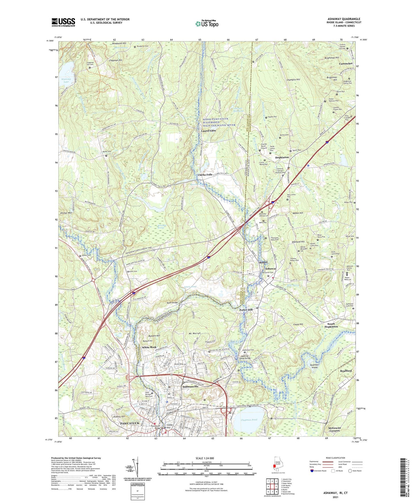
Ashaway Rhode Island US Topo Map
Couldn't load pickup availability
2021 topographic map quadrangle Ashaway in the states of Connecticut, Rhode Island. Scale: 1:24000. Based on the newly updated USGS 7.5' US Topo map series, this map is in the following counties: Washington, New London. The map contains contour data, water features, and other items you are used to seeing on USGS maps, but also has updated roads and other features. This is the next generation of topographic maps. Printed on high-quality waterproof paper with UV fade-resistant inks.
Quads adjacent to this one:
West: Old Mystic
Northwest: Jewett City
North: Voluntown
Northeast: Hope Valley
East: Carolina
Southeast: Quonochontaug
South: Watch Hill
Southwest: Mystic
Contains the following named places: Aguntaug Brook, Ashaway, Ashaway Ambulance Association, Ashaway Bible Chapel, Ashaway Census Designated Place, Ashaway Elementary School, Ashaway Free Library, Ashaway Post Office, Ashaway River, Ashaway Volunteer Fire Department, Babcock Family Lot Cemetery, Babcock Presbyterian Church, Babcock-Smith House Museum, Bell Cedar Swamp, Bethel, Boom Bridge, Bradford Census Designated Place, Brightman Hill, Brown Cemetery, Bumpin Hill, Burch Pond, Burton Lot Cemetery, Captain Joseph Spicer Lot Cemetery, Central Baptist Church, Central Nursery School, Champlin Hill, Chapman Hill, Chapman Hill Cemetery, Chapman Pond, Chase Hill, Christ Episcopal Church, Clarks Falls, Cooky Hill, Curtis Maine Lot Cemetery, Daniel Lewis Plot, Daniel Peckham Lot, Diamond Hill, Elias Lewis Lot Cemetery, Elm Ridge Golf Course, Enos - Crandall Plot, First Hopkinton Cemetery, Foster - Spencer Plot, Francis Tanner Lot Cemetery, Friend's Burial Ground, General George Thurston Lot Cemetery, Glade Brook, Grace United Methodist Church, Green Fall River, Harvest Chapel, Hetchel Swamp, Hetchel Swamp Brook, High Street Post Office, Hinkley Hill, Hopkinton, Hopkinton Census Designated Place, Hopkinton City Historic District, Hopkinton Police Department, Hopkinton Post Office, Hopkinton Town Hall, Immaculate Conception Church, Kedinker Island, Kindal Oatley Lot Cemetery, Laurel Glen, Lawton Foster Plot, Lewis Pond, Littlebrook Child Development Center, Littlebrook Kids Day Care Center, Maine Cemetery, Mary Lewis Plot, Maxon Hill, McGowan Brook, McGowan Corners, Meeting-House Bridge, Mile Brook, Mount Moriah, Murre Plot, Nathaniel Cook Plot, Newton Swamp Management Area, North Stonington Christian Academy, Noyes - Wells Lot Cemetery, Oak Grove Cemetery, Old Sabbatarian Meeting-House, Our Lady of Victory Church, Parmenter Brook, Pawcatuck, Pawcatuck Bridge, Pawcatuck Census Designated Place, Pawcatuck Fire Department, Pawcatuck Seventh Day Baptist Church, Pawcatuck Shopping Center, Pendleton Cemetery, Pendleton Hill Brook, Peter Davis Plot, Pilgrims Baptist Church, Potter Hill, Potter Hill Dam, Randall Wells Lot Cemetery, Red Brook, Reynolds - Johnson Lot Cemetery, Saint Michael New Cemetery, Saint Michael School, Saint Michaels Church, Saint Puis X School, Sarah Larkin Lot Cemetery, Seventh Day Baptist Church, Shingle Mill Pond, Shunock River, South Hopkinton, Spalding Pond, Spaulding Pond Dam, Springbrook Elementary School, Stillmanville, Thomas Brightman Lot Cemetery, Thomas Wilbur Plot, Thompson Wells Lot Cemetery, Tomaquag Brook, Tower Street School, Town of Hopkinton, Trinity Lutheran Church, Trinity Lutheran Preschool, Union Cemetery, United Congregational Church, Watch the Lamb Preschool, West Broad Street School, West Vine Street School, Westerly, Westerly Armory, Westerly Downtown Historic District, Westerly Fire Department Station 1 Headquarters, Westerly High School, Westerly Junior High School, Westerly Memorial Building, Westerly Police Department Substation 1, Westerly Public Library, Westerly Town Hall and Courthouse, Westerly-Pawcatuck YMCA Preschool, White Rock, White Rock Dam, Wilbur Lot Cemetery, Wilcox Arboretum, Wilcox Park Historic District, Wine Brook, Witter Lot Cemetery, Wyassup Brook, Wyassup Lake, Wyassup Lake Dam, ZIP Codes: 02804, 02833, 06359