MyTopo
Brookgreen South Carolina US Topo Map
Couldn't load pickup availability
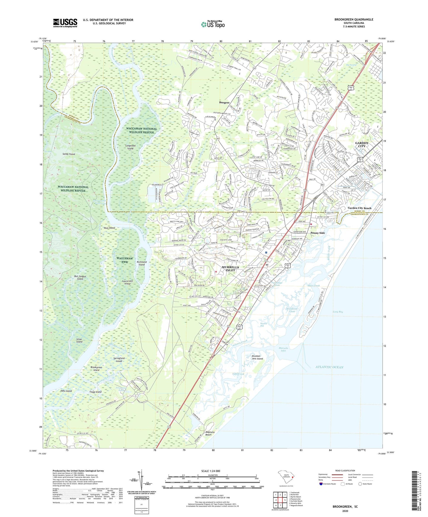
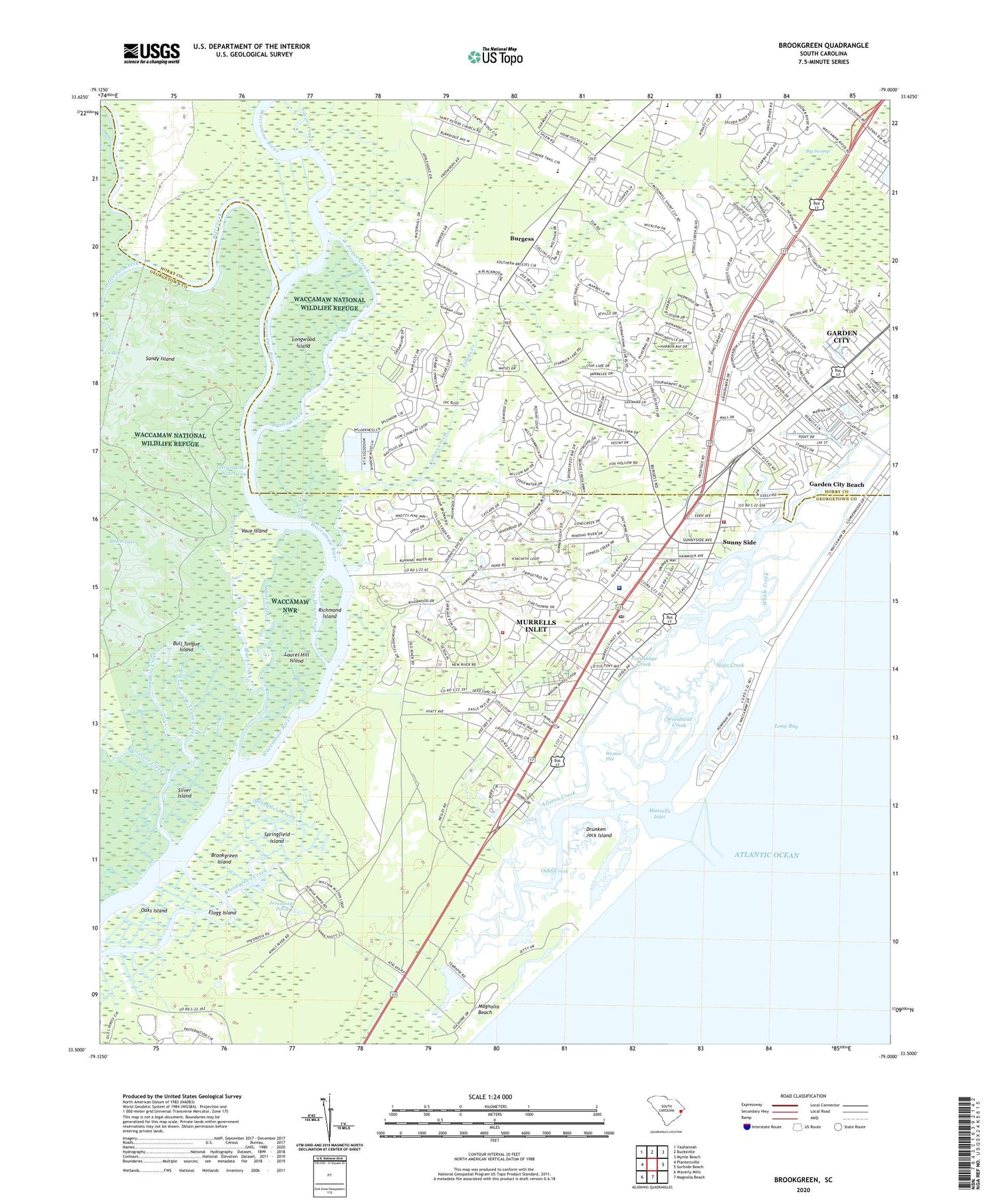
2020 topographic map quadrangle Brookgreen in the state of South Carolina. Scale: 1:24000. Based on the newly updated USGS 7.5' US Topo map series, this map is in the following counties: Georgetown, Horry. The map contains contour data, water features, and other items you are used to seeing on USGS maps, but also has updated roads and other features. This is the next generation of topographic maps. Printed on high-quality waterproof paper with UV fade-resistant inks.
Quads adjacent to this one:
West: Plantersville
Northwest: Yauhannah
North: Bucksville
Northeast: Myrtle Beach
East: Surfside Beach
South: Magnolia Beach
Southwest: Waverly Mills
Contains the following named places: Allston Creek, Atalaya Mansion, Atlantic Surgery Center, Belin Memorial Methodist Church, Bethel Church, Black Creek, Blue Heron, Brookgreen Creek, Brookgreen Gardens, Brookgreen Island, Brookgreen Plantation, Brown School, Browns Church, Bull Creek, Bull Tongue Island, Burgess, Captains Cove, Carriage Run, Collins Creek, Collins Creek Church, Cow House Creek, Crane Creek, Crystal Oaks, Drunken Jack Island, Eagle Crest, Fisherman Creek, Flagg Island, Garden City, Garden City Beach, Garden City Beach Post Office, Garden City Census Designated Place, Gordons Church, Huntington Beach State Park, Huntington Estate, Huntington Marsh, Inlet Crossing Shopping Center, Inlet Harbor, Inlet Oaks Village, Jamestown, Jensens, Jerusalem Church, Jessamine Pond, Laurel Hill Church, Laurel Hill Island, Laurel Hill School, Little Bull Creek, Live Oaks, Longwood Island, Longwood Landing, Main Creek, Marlin Quay Marina, Moss Creek, Mount Gilead, Mulberry Landing, Murrells Inlet, Murrells Inlet Census Designated Place, Murrells Inlet Church of God, Murrells Inlet Community Center, Murrells Inlet Fire Department Station 76, Murrells Inlet Fire Department Station 78, Murrells Inlet Historic District, Murrells Inlet Park, Murrells Inlet Post Office, Murrells Inlet School District, Murrells Inlet Wastewater Treatment Plant, Oak Hill, Oaks Creek, Oaks Island, Ocean Pines, Parsonage Creek, Pirate Cove, Prince Creek, Ragtops and Roadsters Auto Museum, Richmond Hill, Richmond Hill Plantation, Richmond Island, Robin Hood, Ruinsville Creek, Saint James Elementary School, Saint James High School, Saint James Middle School, Saint Peters Church, Sandhole Creek, Sandy Island, Seabreeze, Seaside Elementary School, Silver Creek, Silver Island, Silvers Creek, Springfield Creek, Springfield Island, Springfield Plantation, Still Creek, Sunny Side, Surfside Christian Church, Thompson, Trinity Presbyterian Church, Vaux Creek, Vaux Island, Waccamaw Community Hospital, Waccawache Marina, Wachasaw Plantation, Wachesaw Landing, Wachesaw Place, Wayside Forest, WBPR-FM (Georgetown), WCRD-TV (Myrtle Beach), Weston Flat, Whale Creek, White Creek, Wildwood School, Windjammer Village, Woodland Creek, WYAK-AM (Surfside Beach-Garden City Beach), WYAK-FM (Surfside Beach), WYAV-FM (Conway), ZIP Code: 29576