MyTopo
Abingdon Virginia US Topo Map
Couldn't load pickup availability
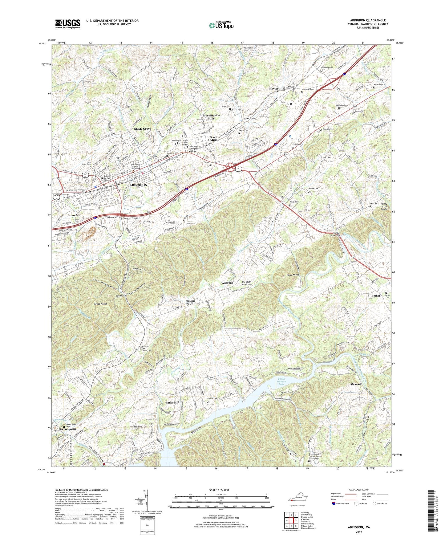
2019 topographic map quadrangle Abingdon in the state of Virginia. Scale: 1:24000. Based on the newly updated USGS 7.5' US Topo map series, this map is in the following counties: Washington. The map contains contour data, water features, and other items you are used to seeing on USGS maps, but also has updated roads and other features. This is the next generation of topographic maps. Printed on high-quality waterproof paper with UV fade-resistant inks.
Quads adjacent to this one:
West: Wyndale
Northwest: Brumley
North: Hayters Gap
Northeast: Glade Spring
East: Damascus
Southeast: Laurel Bloomery
South: Shady Valley
Southwest: Holston Valley
Contains the following named places: Abingdon, Abingdon Ambulance Service, Abingdon City Hall, Abingdon Fire Department, Abingdon High School, Abingdon Police Department, Abingdon Post Office, Abingdon Town Centre Shopping Center, Abington Historic District, Abington United Methodist Church, Alvarado, Ashleys, Baugh Cemetery, Berrys Creek, Bethel, Bethel Cemetery, Bethel Church, Blind Hollow, Bowman Branch, Browning Cemetery, Bumgardner Branch, Camp Glenrochie, Campbell Cemetery, Campbell Hollow, Central Public School, Charles Wesley United Methodist Church, Crooked Branch, Denton Cemetery, Denton Ford, Dry Branch, E B Stanley Middle School, East Fork Wolf Creek, Fairview School, Fifteenmile Creek, First Baptist Church, Free Zion Church, General Morgan Bridge, Gill Hollow, Glenrochie Country Club, Good Shepherd Chapel, Goodhope School, Gray Cemetery, Great Knobs, Green Spring, Green Spring Cemetery, Green Spring Presbyterian Church, Green Springs Volunteer Fire Department & Rescue Squad, Greendwood Freewill Baptist Church Cemetery, Greenwood Church, Grubb Cemetery, Hagy Cemetery, Halfmile Creek, Harrison District, Hayter, Hayter Bridge, Hayter Cemetery, High Point Cemetery, Holston Valley, Honey Locust Knobs, Johnston Memorial Hospital, Jordan Hollow, Keller Cemetery, Kings Mountain School, Knollkreg Cemetery, Larimer Branch, Larimer School, Larmer Cemetery, Latture Field, Lebanon Church, Lick Branch, Locustdale School, Louse Creek, Macedonia Church, Madison District, Mays Branch, McConnell, Middle Fork Holston River, Middleton Cemetery, Miller Cemetery, Minton Cemetery, Morningside Hills, Mount View Church, Mountain View Church Cemetery, Neff Cemetery, Old South Aerodrome, Overmountain Victory National History Trail, Palestine Church, Parks Mill, Parks School, Pendleton Branch, River Knobs, Roberts Church, Rockhouse Run, Rosedale Cemetery, Rosedale Church, Saint Thomas Episcopal Church, Sawmill Branch, Scott Addition, Shady Grove, Shallow Ford Bridge, Sharp Branch, Shiloh School, Sinking Spring Cemetery, Sinking Spring Presbyterian Church, Sinking Springs Church, Southwest Virginia 4-H Center, Southwest Virginia Regional Jail Authority - Abingdon Facility, Spoon Gap Creek, Stone Mill, Stony Point School, Sweet Hollow, Temple Christian School, Town Creek, Town of Abingdon, Valley Street Baptist Church, Vance Mill, WABN-FM (Abingdon), Washington Chapel, Washington Chapel Cemetery, Washington County, Washington County Career and Technical Education Center, Washington County Courthouse, Washington County Farm, Washington County Jail, Washington County Life Saving Crew, Washington County Prison Farm, Washington County Public Library, Washington County Skill Center, Washington County Technical School, Watauga, Watauga Chapel, Watauga Elementary School, Watauga Valley, WBBI-AM (Abingdon), White Branch, Wilkinson Cemetery, William King High School, Wood Hollow, ZIP Code: 24211