
MyTopo
Amherst Virginia US Topo Map
Couldn't load pickup availability
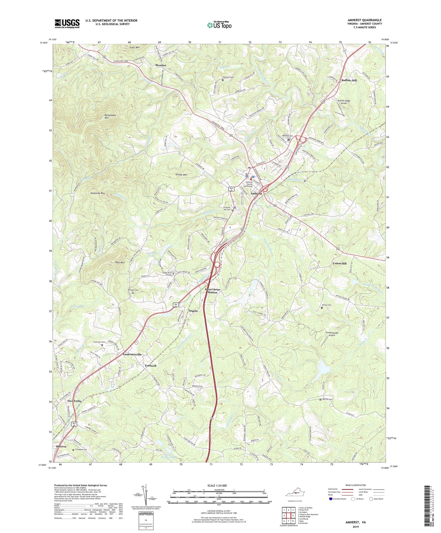
2019 topographic map quadrangle Amherst in the state of Virginia. Scale: 1:24000. Based on the newly updated USGS 7.5' US Topo map series, this map is in the following counties: Amherst. The map contains contour data, water features, and other items you are used to seeing on USGS maps, but also has updated roads and other features. This is the next generation of topographic maps. Printed on high-quality waterproof paper with UV fade-resistant inks.
Quads adjacent to this one:
West: Tobacco Row Mountain
Northwest: Forks of Buffalo
North: Piney River
Northeast: Arrington
East: Buffalo Ridge
Southeast: Stonewall
South: Kelly
Southwest: Lynchburg
Contains the following named places: Amherst, Amherst Cemetery, Amherst County High School, Amherst County Public Library, Amherst County Sheriffs Office, Amherst County Sheriff's Office, Amherst Elementary School, Amherst Life Saving and First Aid Crew, Amherst Middle School, Amherst Police Department, Amherst Post Office, Amherst Training School, Amherst Volunteer Fire Department, Angelo, Anne Gary Pannell Center, Babcock Fine Arts Center, Benedict Building, Berkley Church, Boxwood Alumnae House, Buffalo Hill, Buffalo Ridge Airport, Campbell Cemetery, Carl Grammer Hall, Carson Dormitory, Carson Residence Hall, Carter Branch, Central Elementary School, Central High School, Christian Aid Cemetery, Cochran Library, Coolwell, Coolwell Church, Cox Branch, Dew Residence Hall, Dorothy J Sales Building, Early Dam, Early Lake, Ebenezer Baptist Church, Elston Inn and Conference Center, Faulconer Cemetery, Faulconerville, Fergus Reid Hall, First Baptist Church of Coolwell, Five Forks, Fletcher Building, Fletcher Hall, Graduate Student Housing, Grammer Residence Hall, Gray Dormitory, Guion Science Center, Harrison Cemetery, Higginbotham Creek, Hockey Field, Huff Creek, Izaak Walton Dam, Izaak Walton Park, Izaak Walton Pond, Kentucky Mountain, Lake Tennis Courts, Manson Hall, Manson Residence Hall, Mary Clark Rogers Garden Cottage, Mary Harley Student Health Center, Mary Helen Cochran Library, Meta Glass Residence Hall, Monitor, Monroe Educational Center, Morriss Cemetery, Mount Airy School, Mount Olive Baptist Church, Mud Creek, Paul Mountain, Prothro Hall, Prothro Natatorium, Randolph Hall, Randolph Residence Hall, Reid Residence Hall, Richardson Mountain, Riding Hunt Course, Rutledge Creek, Sardis, Sardis United Methodist Church, Strode Mountain, Student Commons Courtyard, Sweet Briar College, Sweet Briar House, Sweet Briar Museum, Sweet Briar Station, Sweetbriar College Lower Dam, Sweetbriar College Upper Dam, Sweetbriar Lake, Timberdoodle Airport, Town of Amherst, Train Station and Caboose, Tribulation Creek, Union Hill, Union Hill Baptist Church, Virginia State Police Division 3 Area 20 Office, WAMV-AM (Amherst), Williams Cemetery, Williams Creek, Williams Gymnasium, Wilson Cemetery, WUDZ-FM (Sweet Briar), ZIP Code: 24595


