MyTopo
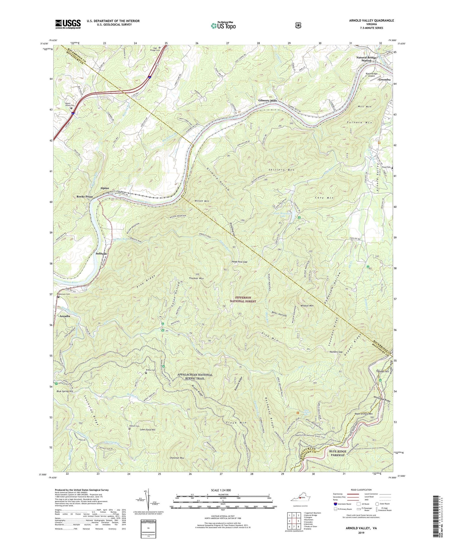
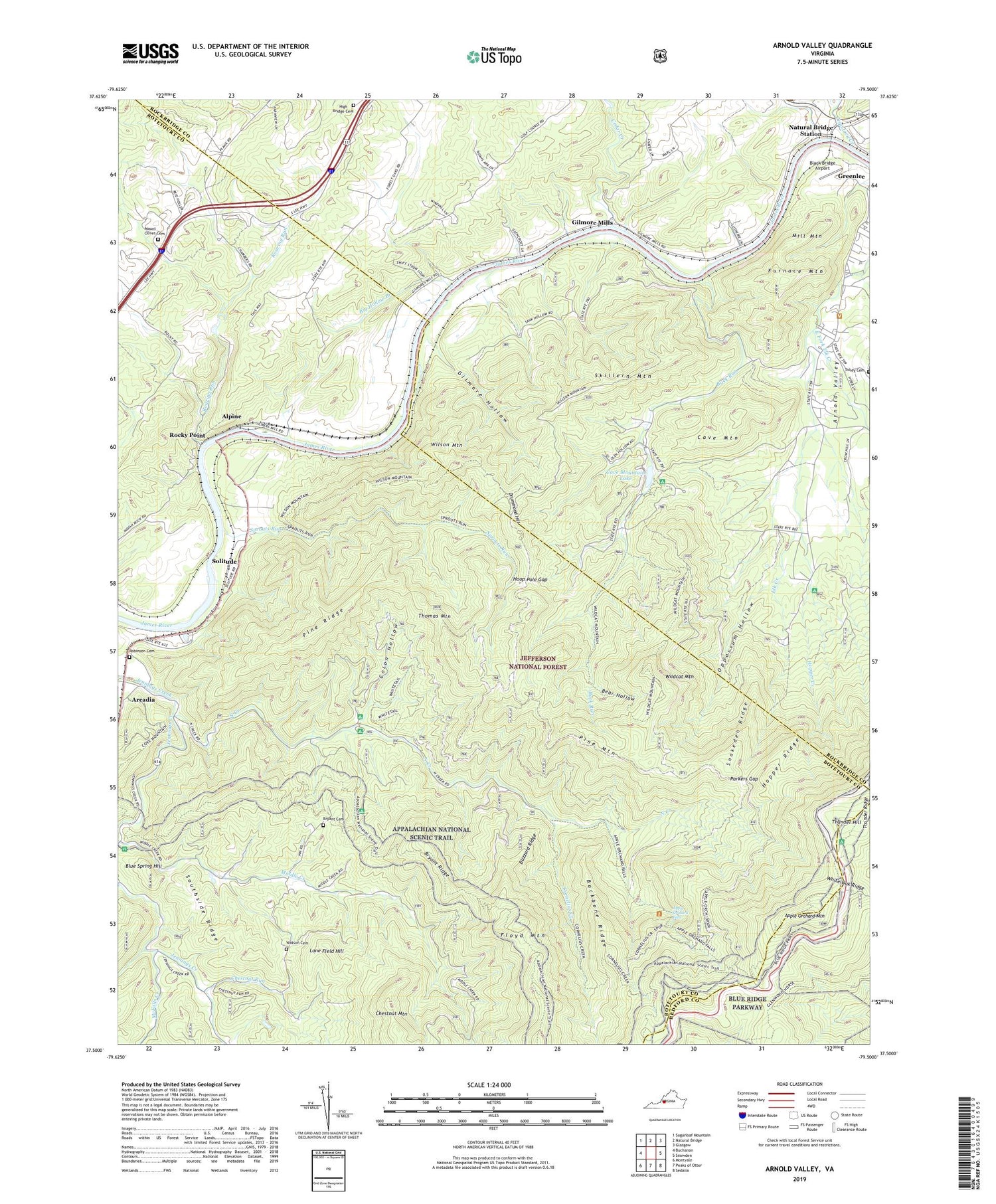
Arnold Valley Virginia US Topo Map
Couldn't load pickup availability
2019 topographic map quadrangle Arnold Valley in the state of Virginia. Scale: 1:24000. Based on the newly updated USGS 7.5' US Topo map series, this map is in the following counties: Botetourt, Rockbridge, Bedford. The map contains contour data, water features, and other items you are used to seeing on USGS maps, but also has updated roads and other features. This is the next generation of topographic maps. Printed on high-quality waterproof paper with UV fade-resistant inks.
Quads adjacent to this one:
West: Buchanan
Northwest: Sugarloaf Mountain
North: Natural Bridge
Northeast: Glasgow
East: Snowden
Southeast: Sedalia
South: Peaks of Otter
Southwest: Montvale
Contains the following named places: Alpine, Apple Orchard Falls, Apple Orchard Mountain, Arcadia, Back Run, Backbone Ridge, Bear Hollow, Bedford Air Force Station, Big Hollow Branch, Black Bridge Airport, Blue Spring Hill, Bryant Cemetery, Bryant Ridge, Buzzard Ridge, Cave Mountain, Cave Mountain Church, Cave Mountain Dam, Cave Mountain Lake, Cave Mountain Recreation Area, Cedar Creek, Chestnut Run, Colon Hollow, Colon Hollow Shelter Campground, Cornelius Creek, Cove Creek, Cove Mountain Trail, Crawford Creek, Drummond Hill, East Fork Elk Creek, Faith Church, Fork Mountain, Furnace Mountain, Gilmore Hollow, Gilmore Mills, Glenwood Church, Glenwood Furnace, Harvey, High Bridge Cemetery, Hoop Pole Gap, Hopper Creek, Hopper Creek Group Camp, Hopper Ridge, Jennings Creek Church, Little Hellgate Creek, Lone Field Hill, McFalls Creek, Middle Creek Picnic Area, Mill Mountain, Mount Olivet Cemetery, Mount Olivet Church, Munford, Natural Bridge Camp for Boys, Natural Bridge District, Natural Bridge Station, North Creek, North Creek Camping Area, Oppossum Hollow, Parkers Gap, Pine Mountain, Pine Ridge, Roaring Run, Robinson Cemetery, Rocky Point, Skillern Mountain, Smith Tract Campground, Snakeden Ridge, Solitude, Southside Ridge, Sprouts Run, Sugarland, Sunset Field, Thomas Mountain, Thunder Hill, Thunder Hill Shelter, Tolley Cemetery, Watson Cemetery, White Oak Ridge, Wildcat Mountain, Wildcat Trail, Wilson Mountain, Yellowstone Branch, ZIP Code: 24579