
MyTopo
Atkins Virginia US Topo Map
Couldn't load pickup availability
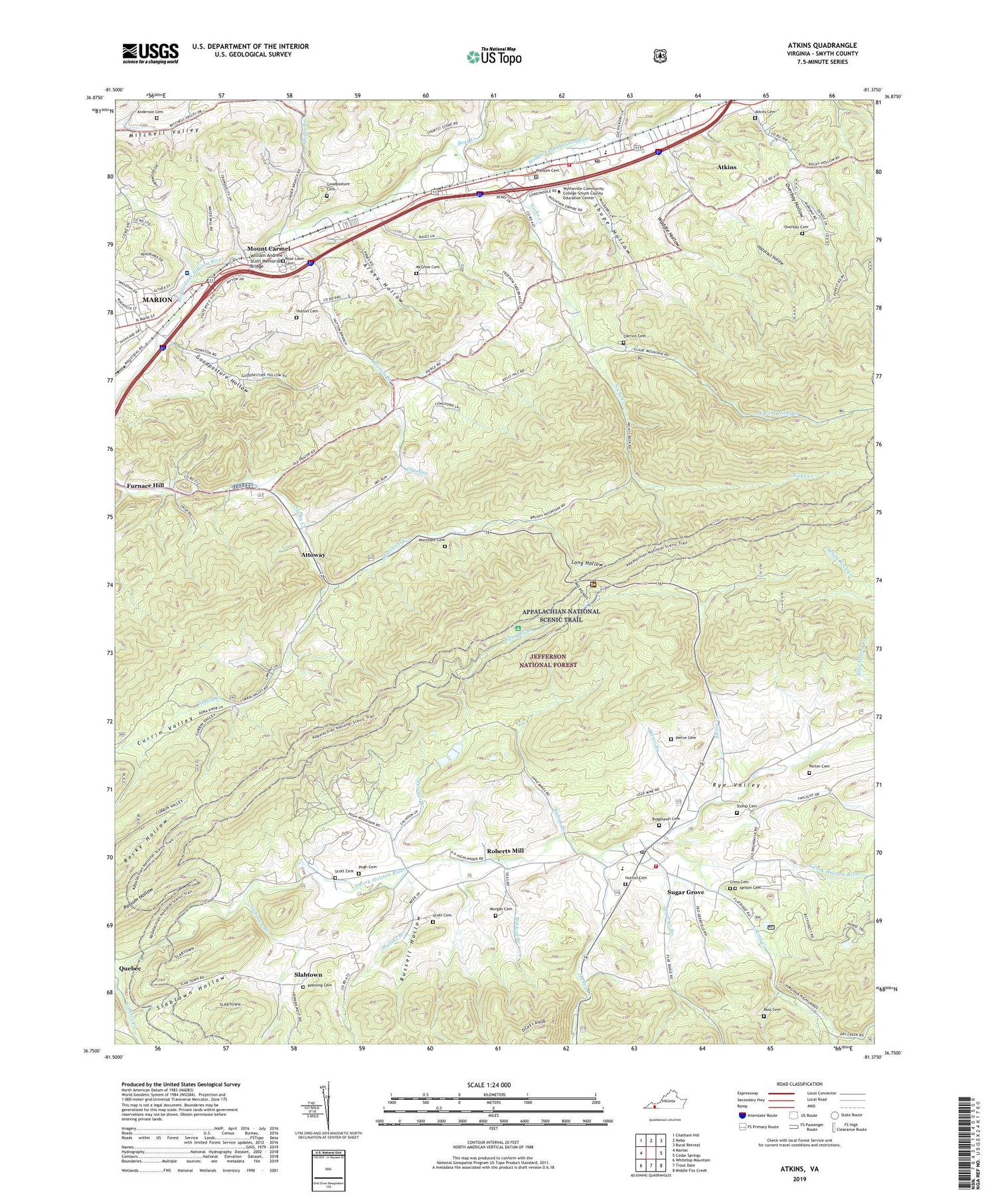
2019 topographic map quadrangle Atkins in the state of Virginia. Scale: 1:24000. Based on the newly updated USGS 7.5' US Topo map series, this map is in the following counties: Smyth. The map contains contour data, water features, and other items you are used to seeing on USGS maps, but also has updated roads and other features. This is the next generation of topographic maps. Printed on high-quality waterproof paper with UV fade-resistant inks.
Quads adjacent to this one:
West: Marion
Northwest: Chatham Hill
North: Nebo
Northeast: Rural Retreat
East: Cedar Springs
Southeast: Middle Fox Creek
South: Trout Dale
Southwest: Whitetop Mountain
Contains the following named places: Anderson Cemetery, Arney Hollow, Atkins, Atkins Cemetery, Atkins Census Designated Place, Atkins Elementary School, Atkins Post Office, Atkins Volunteer Fire Department, Attoway, Bear Creek, Bishop Branch, Cardinal Quarries, Carrico Cemetery, Cedar Bluff Church, Centenary Church, Centenary School, Chestnut Mountain, Comers Creek, Cress Cemetery, Cressy Creek, Currin School, Currin Valley, Davis Memorial Church, Dickey Creek, Dickey Knob, Dry Run, East Fork Nicks Creek, Elizabeth Church, Falling Water Church, First Church of God, Furnace Hill, Furnace Hill Lutheran Church, Georges Branch, Goodpasture Cemetery, Goodpasture Hollow, Goodpasture Ridge, Hazelnut Hollow, Hickory Ridge, Houndshell Branch, Hutton Branch, Hutton Cemetery, Keesling Cemetery, Long Hollow, Marchant Cemetery, Marchant Creek, Marion Plaza Shopping Center, Marion Primary School, Marion State Fish Hatchery, McGhee Cemetery, Mill Mountain, Morgan Cemetery, Mount Carmel, Mount Carmel United Methodist Church, Mount Rogers National Recreation Area Office, Mount Rogers Work Center, Mullins Branch, Nelson Cemetery, Nick Creek School, Nicks Creek, Nicks Creek Church, Overbay Cemetery, Overbay Hollow, Pierce Branch, Pierce Cemetery, Porter Cemetery, Pugh Cemetery, Pugh Mountain Church, Quarter Branch, Ridgelawn Cemetery, Roberts Mill, Rose Lawn Cemetery, Ross Cemetery, Russell Hollow, Russell Ridge, Rye Valley, Rye Valley District, Saint Mathews Church, Scott Cemetery, Shady Grove, Sheep Ridge, Shupe Hollow, Slabtown, Slabtown Branch, Slabtown Hollow, Slemp Cemetery, Slemp Creek, Smyth County Ambulance Service, Smyth County Community Hospital, Snider Branch, Sugar Grove, Sugar Grove Census Designated Place, Sugar Grove Combined School, Sugar Grove Life Saving Crew, Sugar Grove Post Office, Sugar Grove Volunteer Fire Department, Teas, Waddle Hollow, Wassum Cemetery, Wharfhill Church, Wildcat Branch, William Andrew Scott Memorial Bridge, WOLD-AM (Marion), WOLD-FM (Marion), ZIP Codes: 24311, 24375


