MyTopo
Wise Virginia US Topo Map
Couldn't load pickup availability
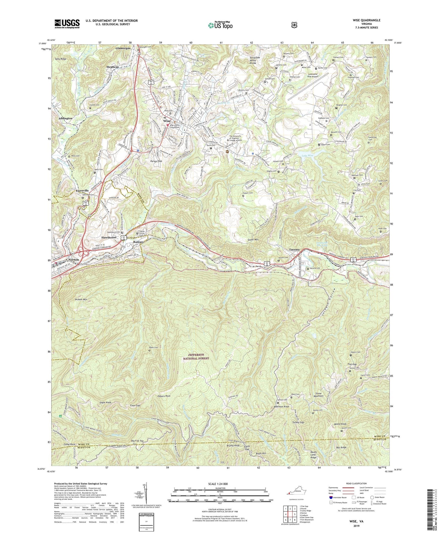
2019 topographic map quadrangle Wise in the state of Virginia. Scale: 1:24000. Based on the newly updated USGS 7.5' US Topo map series, this map is in the following counties: Wise, Scott, Norton (city). The map contains contour data, water features, and other items you are used to seeing on USGS maps, but also has updated roads and other features. This is the next generation of topographic maps. Printed on high-quality waterproof paper with UV fade-resistant inks.
Quads adjacent to this one:
West: Norton
Northwest: Flat Gap
North: Pound
Northeast: Caney Ridge
East: Coeburn
Southeast: Dungannon
South: Fort Blackmore
Southwest: East Stone Gap
Contains the following named places: Addington, Alternative Education School, Bark Camp Branch, Bat Ridge, Bates Cemetery, Bear Creek, Bear Creek Dam, Bear Creek Reservoir, Beckner Chapel, Bennett Cemetery, Berry Chapel, Beverly Cemetery, Big Flat Top, Black Hill, Brushy Knob, Burns Creek, Calvary Chapel, Camp Bethel, Camp Rock, Carter Cemetery, Carter School, Clear Creek, Clear Creek School, Clinch Ranger District Office, Coeburn Airport, Coon Gap, Cox Cemetery, Darter Cemetery, Davey Land Ridge, Davis Chapel, Eagle Knob, Eagle Rock Electrical Complex, Easterling Cemetery, Eastland Creek, Edith Gap, Esserville, Flat Gap, Freeman Cemetery, Gibson Cemetery, Gilliam Cemetery, Glade Creek, Glades Wildlife Management Area, Glamorgan, Glamorgan Cemetery, Glamorgan Chapel, Green Cemetery, Guest Mountain, Hamilton Cemetery, Hamilton Town, Hawthorne, Hawthorne Cemetery, High Knob Recreation Area, Hillman Cemetery, Hubbard Cemetery, Hurricane Church, Intermont Girl Scout Camp, J J Kelly High School, Kilgore Cemetery, Kiser Cemetery, L F Addington Middle School, Lake Wise, Laney Cemetery, Laurel Grove Cemetery, LifeCare Ambulance Service Wise, Lonesome Pine Airport, Lonesome Pine Lake, Lost Creek, Machine Creek, Maple Grove School, Mill Creek, Miller Cemetery, Moore Knob, Mount Olive Church, Mountain View Church, Mountain View School, Nash Cemetery, Nash Chapel, Norton Elementary and Middle School, Norton Volunteer Fire Department Station 2, Osborn Cemetery, Osborn Rock, Osbornes Gap, Parson Branch, Parson Gap, Pickem Mountain, Pole Bridge Branch, Ramsey, Ridge View Shopping Center, Robinson Cemetery, Robinson Fork, Robinson Knob, Rock Switch, Rocky Fork, Sanders Cemetery, School Number 15, School Number 21, Sepulcher Creek, Sexton Cemetery, Shingle Hollow, Skeen Cemetery, Smith Cemetery, Stallard Cemetery, Stallard Church, Stephens, Stidham Fork, Tacoma, Tacoma Cemetery, Tacoma Census Designated Place, Tearall Branch, The Nettle Patch, The University of Virginia's College at Wise, The University of Virginia's College at Wise Census Designated Place, Town of Wise, Turkey Gap, Vaughan Cemetery, Virginia State Police Division 4 Area 30 Office, Ward Cemetery, Wells, Wells Cemetery, Whiteoak Branch, Wise, Wise A R Hospital Heliport, Wise Cemetery, Wise County, Wise County Career - Technical Center, Wise County Christian School, Wise County Memorial Hospital, Wise County Sheriff's Office, Wise Mountain Lookout Tower, Wise Police Department, Wise Post Office, Wise Primary School, Wise Rescue Squad, Wise Volunteer Fire Department, WNVA-AM (Norton), WNVA-FM (Norton), WSBN-TV (Norton), Yellow Creek