
MyTopo
Arlington West Washington US Topo Map
Couldn't load pickup availability
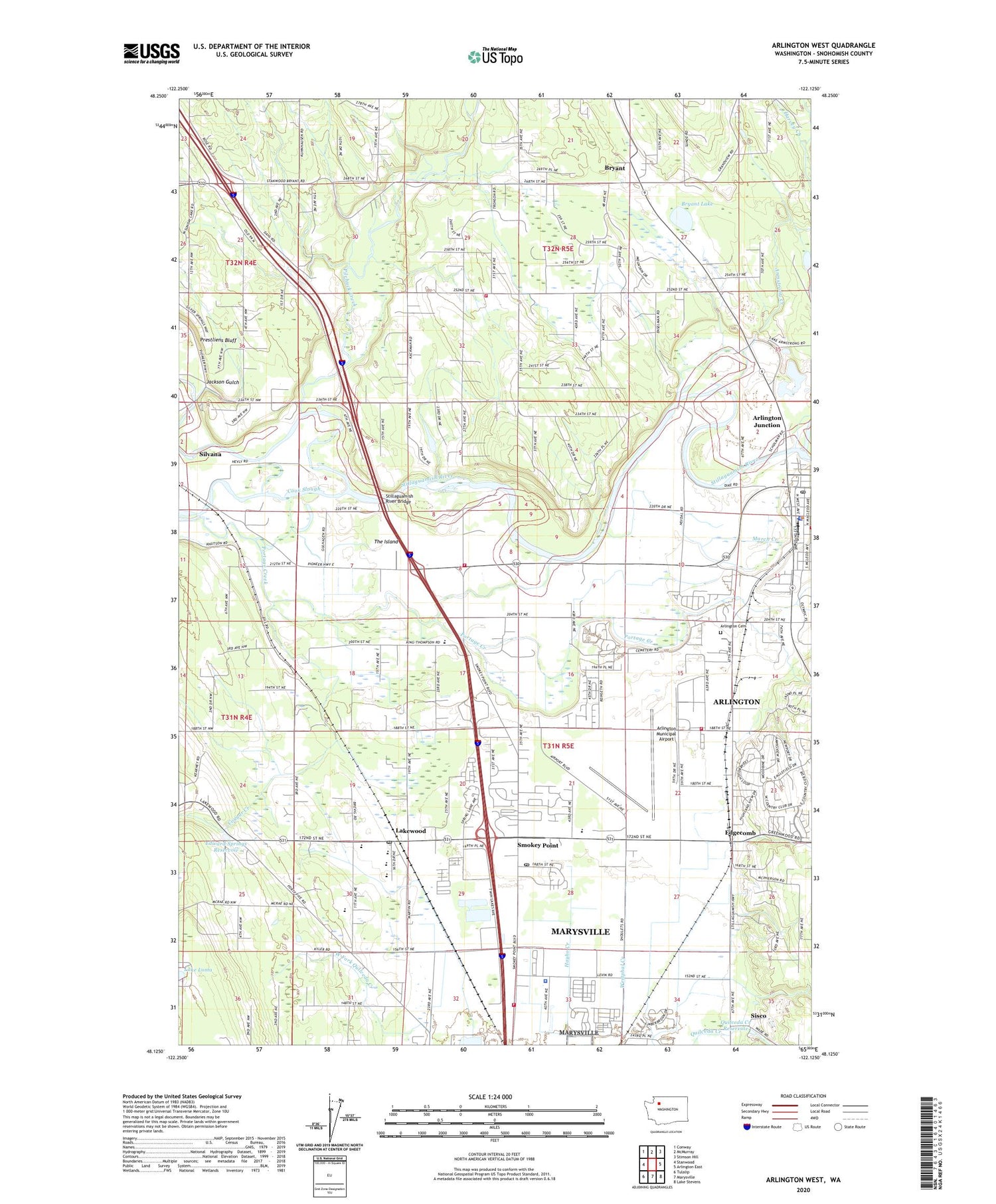
2020 topographic map quadrangle Arlington West in the state of Washington. Scale: 1:24000. Based on the newly updated USGS 7.5' US Topo map series, this map is in the following counties: Snohomish. The map contains contour data, water features, and other items you are used to seeing on USGS maps, but also has updated roads and other features. This is the next generation of topographic maps. Printed on high-quality waterproof paper with UV fade-resistant inks.
Quads adjacent to this one:
West: Stanwood
Northwest: Conway
North: McMurray
Northeast: Stimson Hill
East: Arlington East
Southeast: Lake Stevens
South: Marysville
Southwest: Tulalip
Contains the following named places: Air Station Museum, Airway Mobile Home Park, Arlington, Arlington Airport Park, Arlington Cemetery, Arlington Christian School, Arlington City Hall, Arlington Fire Department Station 47, Arlington Junction, Arlington Municipal Airport, Arlington Police Department, Arlington Post Office, Arlington Quarry, Arlington Sewage Treatment Plant, Armstrong Creek, Atonement Free Lutheran Church, Barlond Farms, Blue Stilly Park, Bryant, Bryant Census Designated Place, Bryant Community Church, Bryant Lake, City of Arlington, Cook Slough, Cougar Creek, Cougar Creek Elementary School, Crystal Tree Village Mobile Home Park, Eagle Point Mobile Home Park, Edgecomb, Edward Springs Reservoir, Edward Springs Reservoir Dam, Emerald Hills Estates Mobile Home Park, Emmanuel Baptist Church, English, English Crossing Elementary School, Faith Lutheran Church, Forest Grove Mobile Home Park, Giles Dairy, Gleneagle Golf Course, Haller Bridge Park, Harvey Creek, Hidden Glen Mobile Home Park, Interstate 5 and Highway 531 Park and Ride, Jackson Gulch, Kids N Play Learning Center, Kingdom Hall of Jehovahs Witnesses, Klein Breekveldt Waste Storage Pond, Lakewood, Lakewood Elementary School, Lakewood High School, Lakewood Middle School, March Creek, Marysville Fire District Station 63 Midway, Midway Gardens Mobile Park, Miller Shingle Quarry, Mobile Estates, Naval Auxiliary Air Station Arlington, North County Fire / Emergency Medical Services Station 90 Kackman, North Fork Stillaguamish River, North Lakewood Post Office, Pilchuck Creek, Pine View Dairy, Portage Creek, Quilceda Creek Dam, Quilceda Creek Reservoir, Quilceda Trout Farm Dam, Regency Care Center at Arlington, Rio Mount Dam, Riverside Mobile Home Park, Sather Dairy, Silvana Census Designated Place, Sisco, Smokey Point, Smokey Point Census Designated Place, Smokey Point Church of Christ, Smokey Point Community Church, Smokey Point Daycare and Kindergarten, Smokey Point Mobile Home Park, Smokey Point Post Office, Snohomish County Fire District 19 Station 95, Snohomish County Fire Protection District 18 Station 1, Snohomish County Sheriff's Office North Precinct, South Fork Stillaguamish River, Stanwood I Park and Ride, Stillaguamish Reservation, Stillaguamish River Bridge, Sundown Farms, The Island, Totem Park, Van Putten Dairy, Van Slageren Dairy, Weston High School, Westphal Creek


