MyTopo
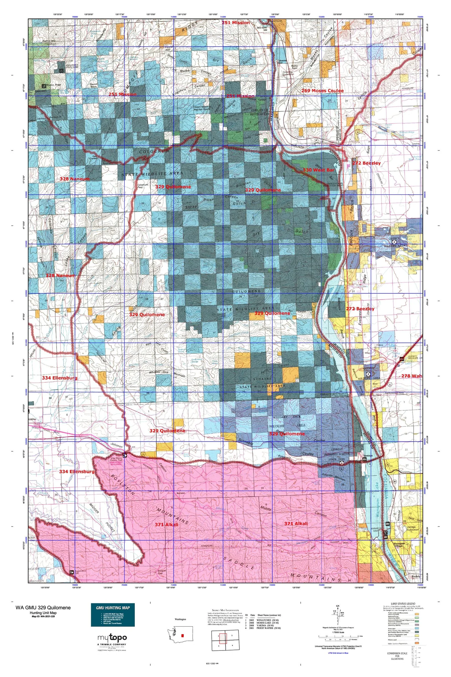
Washington GMU 329 Quilomene Map
Couldn't load pickup availability
Hunting unit map of Washington Game Management Unit 329 with topographic lines and unit boundaries. This topo map features UTM / MGRS and Latitude/Longitude grids, plus public land ownership. It comes folded on waterproof paper.
This map contains the following named places: 98828,98850,98950,Babcock Bench,Babcock Ridge,Basalt Spring,Big Stemilt Creek,Black Rock Canyon,Bohinkleman Spring,Bonspur,Box Canyon,Boylston,Boylston Mountains,Brewton Gulch,Brushy Creek,Bryant Creek,Bryant Spring,Buckhorn Spring,Cabinet Rapids,Cammack Dam,Cape Horn,Cheviot,Clear Lake,Clear Lake Dam,Collins Spring,Colockum Creek,Colockum Game Range,Colockum Game Range Headquarters,Colockum Pass,Colockum Research Unit Washington State University,Colockum State Wildlife Area,Columbia River,Columbia Substation,Crater Coulee,Crescent Bar,Crescent Bar Census Designated Place,Crescent Bar Recreational Area,Crescent Bar Resort and Golf Course,Davies Canyon,Dorse Spring,Douglas Creek,Dry Gulch,East Kittitas,Evergreen Ridge,Foster Creek,Four Corners,Frenchman Coulee,Frenchman Spring,Ginkgo Petrified Forest State Park,Government Springs,Grant County Fire District 3 Station 36,Grant County Fire District 3 Station 37,Greenwood Reservoir Number One,Greenwood Reservoir Number One Dam,Greenwood Reservoir Number Two,Greenwood Reservoir Number Two Dam,Hartman Creek,Hells Kitchen,Highline Canal,Hinkleman Canyon,Hinkleman Spring,Hole in the Wall,Horse Canyon,Hult Butte,Hunt Creek,Ivy Walker Canyon,Jackknife Creek,Johnson Canyon,Judkins Spring,Jumpoff Ridge,KCWT-TV (Wenatchee),Kingsbury Canyon,Kittitas County Fire District 4,Kittitas Micro-Wave Station,Kittitas Valley Fire and Rescue,Kohler Spring,Laurel Hill,Lily Lake,Lily Lake Dam,Little Bohinkleman Creek,Little Brushy Creek,Little Caribou Creek,Little Stemilt Creek,Lone Pine Canyon,Lone Rock,Lone Star Spring,Lynch Coulee,Malaga Division,Mathison Reservoir,Mathison Reservoir Dam,Middle Creek,Milo Wood Pond,Milo Wood Pond Dam,Moses Coulee,Mountain Home,Nickles Canyon,Nixon Rapids,North Branch Canal,North Fork Brushy Creek,North Fork Colockum Creek,North Fork Hunt Creek,North Fork Perkins Fork,North Fork Skookumchuck Creek,North Fork Whiskey Dick Creek,Northeast Kittitas Division,Orr Creek,Patte Canyon,Perkins Fork,Pine Spring,Poison Spring,Pole Flat,Potholes Coulee,Quilomene Creek,Quilomene Creek Dam,Quilomene Wildlife Recreation Area,Renslow,Reynolds Spring,Robinson Canyon,Rock Spring,Rocky Coulee,Rocky Point,Rollinger Creek,Rose Lake,Rose Lake Dam,Ryegrass Coulee,Ryegrass Mountain,Sagebrush Spring,Scammon Landing,Schaake State Wildlife Recreation Area,Schnebly Coulee,Scroggie Canyon,Seabrock Spring,Sheep Creek,Sheridan Spring,Skookumchuck Creek,Skookumchuck Heights Spring,South Fork Brushy Creek,South Fork Colockum Creek,South Fork Hunt Creek,South Fork Tarpiscan Creek,Spike Spring,Spring Cayuse Creek,Spring Gulch,Spring Hill Dam,Spring Hill Reservoir,Spring Hill Saddle Dam,Steffen Brothers Reservoir,Steffen Brothers Reservoir Dam,Stemilt Basin,Stemilt Hill,Stemilt Main Dam,Stemilt Project Reservoir,Stemilt Saddle Dam,Stray Gulch,Sumac Spring,Sunland Estates,Sunland Estates Census Designated Place,Tarpiscan Creek,Tekison Creek,The Pines,Thorn Spring,Trinidad,Upper North Fork Skookumchuck Creek,Upper Wheeler Dam,Vantage,Vantage Airport,Vantage Census Designated Place,Vantage Post Office,Vulcan,Walling Canyon,Wanapum Lake,Wanapum Recreation Area,Wenatchee Heights Reservoir Number One,Wenatchee Heights Reservoir Number One Dam,Wenatchee Heights Reservoir Number Two,Wenatchee Heights Reservoir Number Two Dam,West Bar,Wheeler Hill,Whiskey Dick Creek,Whiskey Dick Mountain,Whiskey Jim Creek,Whitson Canyon,Whitson Spring,Wide Hollow Creek,Wild Horse Spring,Wippe Pumping Station,Wippel Creek