MyTopo
Bridgewater Massachusetts US Topo Map
Couldn't load pickup availability
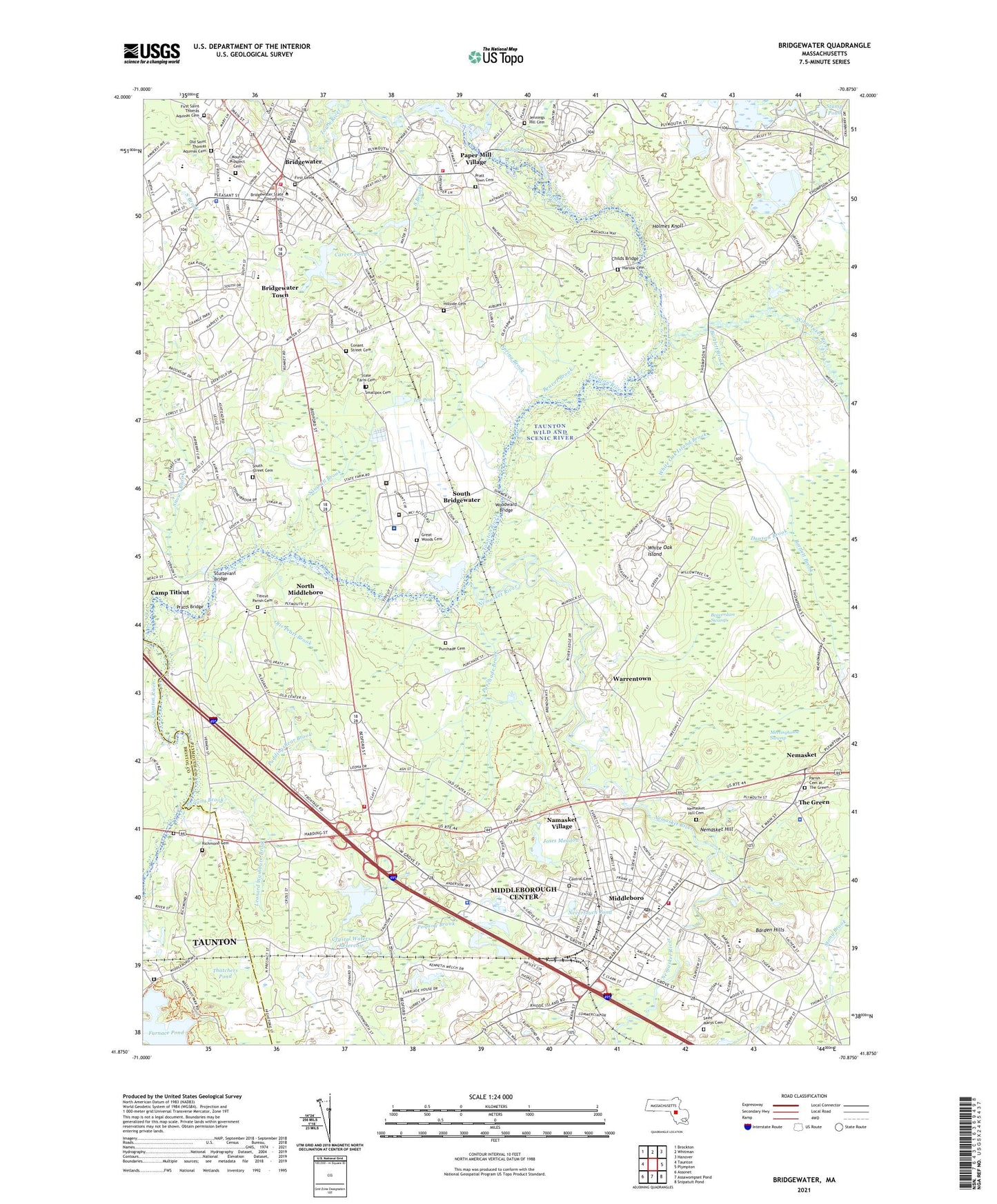
2021 topographic map quadrangle Bridgewater in the state of Massachusetts. Scale: 1:24000. Based on the newly updated USGS 7.5' US Topo map series, this map is in the following counties: Plymouth, Bristol. The map contains contour data, water features, and other items you are used to seeing on USGS maps, but also has updated roads and other features. This is the next generation of topographic maps. Printed on high-quality waterproof paper with UV fade-resistant inks.
Quads adjacent to this one:
West: Taunton
Northwest: Brockton
North: Whitman
Northeast: Hanover
East: Plympton
Southeast: Snipatuit Pond
South: Assawompset Pond
Southwest: Assonet
Contains the following named places: Advent Lutheran Church, Barden Hills, Bartlett Brook, Bassett Brook, Beaver Brook, Beaverdam Brook, Beaverdam Swamp, Blood Pond, Bridgewater, Bridgewater Census Designated Place, Bridgewater Fire Department Station 1 Headquarters, Bridgewater Fire Department Station 2, Bridgewater Police Department, Bridgewater Post Office, Bridgewater Public Library, Bridgewater Raynham Regional High School, Bridgewater State College, Bridgewater State Hospital, Bridgewater Town Hall, Bridgewater Town Hall Annex, Bridgewater-Raynham Regional High School Library Media Center, Burnell Laboratory School, Camp Titicut, Campus Plaza, Campus Plaza Shopping Center, Carver Pond, Carver Pond Dam, Cemetery at The Green, Central Baptist Church, Central Cemetery, Central Congregational Church, Central Square Congregational Church, Childs Bridge, Church in Middleborough, Church of Our Saviour Church, City of Bridgewater Town, Clark School, Clement C Maxwell Library, Conant Street Cemetery, Cranberry Specialty Clinics, Crystal Waters Dam, Crystal Waters Reservoir, Danson Brook, Doctor A F Hunt School, First Cemetery, First Church of Christ Scientist, First Congregational Church, First Parish Unitarian Universalist Church, First Roman Catholic Cemetery, First Saint Thomas Aquinas Cemetery, Furnace Street Flume A Dam, Furnace Street Flume B Dam, Gammons Memorial United Church, Great Woods Cemetery, Harlow Cemetery, Henry B Burkland Intermediate School, Hillside Cemetery, Holmes Knoll, Ice Pond, Jennings Hill Cemetery, John T Nichols Middle School, Joses Meadow, Lakeville State Hospital, Leonard Washburn Brook, Lincoln D Lynch School, Mary K Goode Elementary School, Massachusetts Correctional Institution, Massachusetts Department of Corrections State Hospital Library, Massachusetts State College, Massachusetts State Police Station D4 Middleboro Barracks, Massachusetts Treatment Center Correctional Complex, Matfield River, Mayflower School, Meetinghouse Swamp, Memorial Junior High School, Middleboro, Middleboro Airport, Middleboro High School, Middleboro Junior High School, Middleboro Police Department, Middleboro Post Office, Middleboro United Methodist Church, Middleborough Center Census Designated Place, Middleborough Fire Department Station 1 Headquarters, Middleborough Fire Department Station 3, Middleborough Public Library, Middleborough Station, Middleborough Town Hall, Middleborough Townhall, Middleborough Waterworks, Middleborough-Lakeville Station, Mount Prospect Cemetery, Namasket Village, Nemasket, Nemasket Hill, Nemasket Hill Cemetery, Nemasket River, Nevertouch Pond, North Congregational Church, North Lakeville School, North Lakeville Station, North Middleboro, North Middleborough Post Office, Old Colony Correctional Center, Old Saint Thomas Aquinas Cemetery, Otis Pratt Brook, Paper Mill Village, Pleasant Street School, Plymouth Street School, Poquoy Brook, Poquoy Brook Country Club, Pratt Free School, Pratt Town Cemetery, Pratts Bridge, Puddingshear Brook, Purchade Brook, Purchade Cemetery, Raven Brook, READS Collaborative School, Reynolds Dam, Richmond Cemetery, Route 106 at Robbins Reservoir Dam, Saint Lukes Hospital Heliport, Saint Mary's Cemetery, Saint Thomas Aquinas Church, Saint Thomas School, Sawmill Brook, School Street School, Smallpox Cemetery, Snows Brook, South Bridgewater, South Brook, South Street Cemetery, Southeast Alternative School-Middleborough School, Spring Brook, State Farm Cemetery, Stump Pond, Sturtevant Bridge, Thatchers Pond, The Clement C Maxwell Library, The Green, The Southbrook School, Thompson Brook, Titicut, Titicut Parish Cemetery, Titicut Station, Town River, Town River Reservoir, Trinity Covenant Church, Trinity Covenant School, Trinity Episcopal Church, Turnpike Station, Union Street School, Unitarian Universalist Church, Warrentown, WBIM-FM (Bridgewater), WCEG-AM (Middleborough Center), Westside School, White Oak Island, White Oak Island Brook, William H McElwain School, Williams Elementary School, Williams Junior High School, Winnetuxet River, Woodward Bridge, ZIP Code: 02324