MyTopo
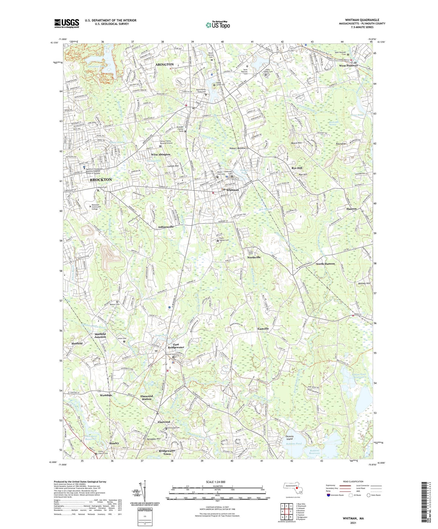
Whitman Massachusetts US Topo Map
Couldn't load pickup availability
2024 topographic map quadrangle Whitman in the state of Massachusetts. Scale: 1:24000. Based on the newly updated USGS 7.5' US Topo map series, this map is in the following counties: Plymouth. The map contains contour data, water features, and other items you are used to seeing on USGS maps, but also has updated roads and other features. This is the next generation of topographic maps. Printed on high-quality waterproof paper with UV fade-resistant inks.
Quads adjacent to this one:
West: Brockton
Northwest: Blue Hills
North: Weymouth
Northeast: Cohasset
East: Hanover
Southeast: Plympton
South: Bridgewater
Southwest: Taunton
This map covers the same area as the classic USGS quad with code o42070a8.
Contains the following named places: Abington, Abington Census Designated Place, Abington Center Post Office, Abington Fire Department Station 2, Abington High School, Abington Junior High School, Abington Police Department, Abington Post Office, Abington Station, All Saints Episcopal Church, Ames Nowell State Park, Ashville School, Auburnville, Bear Meadow, Beaver, Beaver Brook, Beaver Cemetery, Beaver School, Beech Hill, Beech Hill Swamp, Bicknell Family Tomb, Black Brook, Bonney Hill, Brockton East Shopping Plaza, Brockton East Shopping Plaza Shopping Center, Brockton Hospital, Brockton Hospital Library, Browns Station, Burrage Pond - Lower Reservoir, Burrage Pond - Upper Reservoir, Burrage Pond Lower Reservoir Dike A, Burrage Pond Lower Reservoir Dike B, C N Smith Farm, Cardinal Spellman High School, Carriage Crossing Shopping Center, Center School, Central Cemetery, Central School, Central Street School, Cleveland Pond, Cleveland Pond Dam, Colebrook Cemetery, Community Covenant Church, Cotton Gin Pond Dam, Coxs Corner, Curtisville, Cushing Brook, Cushing Pond, Downey School, Drumlin Farms, Duval Elementary School Library, Dyer School, East Bridgewater, East Bridgewater Fire Department, East Bridgewater High School, East Bridgewater Junior High School, East Bridgewater Middle School, East Bridgewater Police Department, East Bridgewater Post Office, East Bridgewater Public Library, East Bridgewater Station, Eastville, East-Way Shopping Center, Egar B Davis School, Elmwood, Elmwood Cemetery, Elmwood Post Office, Elmwood Station, First Congregational Church, Forge Pond, Forge Pond Dam, Frank E Holt School, French Stream, Frilio School, Frolio Junior High School, Gordon W Mitchell School, Grace Bible Church, Gurney School, Hanover Fire Department Station 3, Hanson, Hanson Fire Department Main Street Station, Hanson Middle School, Hanson Station, Hardings Pond, High Street - North Side Dam, Hobart Meadow, Hobart Pond, Holt School, Holy Family Cemetery, Hunts Pond, Hunts Pond Dam, Immanuel Baptist Church, Indian Trail Number Three Reservoir, Indian Trail Reservoir, Indian Trail Reservoir Number Three Dam, Indian Trail Reservoir Number Two Dam, Island Grove Cemetery, Island Grove Park, Island Grove Pond, Island Grove Pond Dam, Jefferson School, John H Duval School, Jones Pond, King Street School, Kingdom Hall of Jehovahs Witnesses, Leach Brook, Leach Cemetery, Locust Hill, Louise A Conley School, Massachusetts Community College Library, Massasoit College, Matfield, Matfield Junction, Matfield Post Office, Matfield Station, Meadow Brook, Metro South Academy, Mount Vernon Cemetery, Mount Zion Cemetery, Nash Family Tomb Cemetery, North Hanson, North Hanson Post Office, North Hanson Station, North River Collaborative School, Northville, Old Church Burying Ground, Osceola Island, Park Avenue Early Childhood Center, Park Avenue Elementary School, Poor Meadow Brook, R Stewart Esten School, Regal Street School, Ridder Country Club, Robbins Pond, Robbins Reservoir, Robbins Reservoir Dam, Rock Church of Rockland, Rockland Golf Course, Rockland Plaza, Rockland Police Department, Roundtop, Rye Hill, Saint Bridgets School, Saint James Cemetery, Saint Josephs Church, Saint Marks Lutheran Church, Saint Nicholas Church, Saint Patricks Cemetery, Salisbury Plain River, Satucket, Satucket River, Sawtucket River Reservoir, Shaw School, Shumatuscacant River, South Hanson, South Hanson Post Office, South Hanson Station, South Shore Pentecostal Church, Spragues Hill, Stanley, Strawberry Valley Golf Course, Stream River, Studleys Pond, Studleys Pond Dam, Stump Pond Dam, Sylvester School, Torrey Family Burying Ground, Town of Abington, Town of East Bridgewater, Town of Whitman, Town River Dam, Town River Reservoir, Trinity Church Cemetery, Union Cemetery, Union Church, United Church of Christ, Washington Street School, Washington Street Station, West Abington, West Hanover, West Hanover Cemetery, West Hanover Post Office, Westdale, Westdale Post Office, Westdale Station, Whitman, Whitman Fire and Rescue, Whitman High School, Whitman Middle School, Whitman Police Department, Whitman Post Office, Whitman Public Library, Whitman Station, Whitman Town Forest, Whitman Town Hall, Whitman Townhall, Whitman-Hanson Regional High School, Whitman-Hanson Regional High School Library, WHRC-TV (Norwell), Winslow Estates, ZIP Codes: 02302, 02333, 02351, 02382