MyTopo
Snipatuit Pond Massachusetts US Topo Map
Couldn't load pickup availability
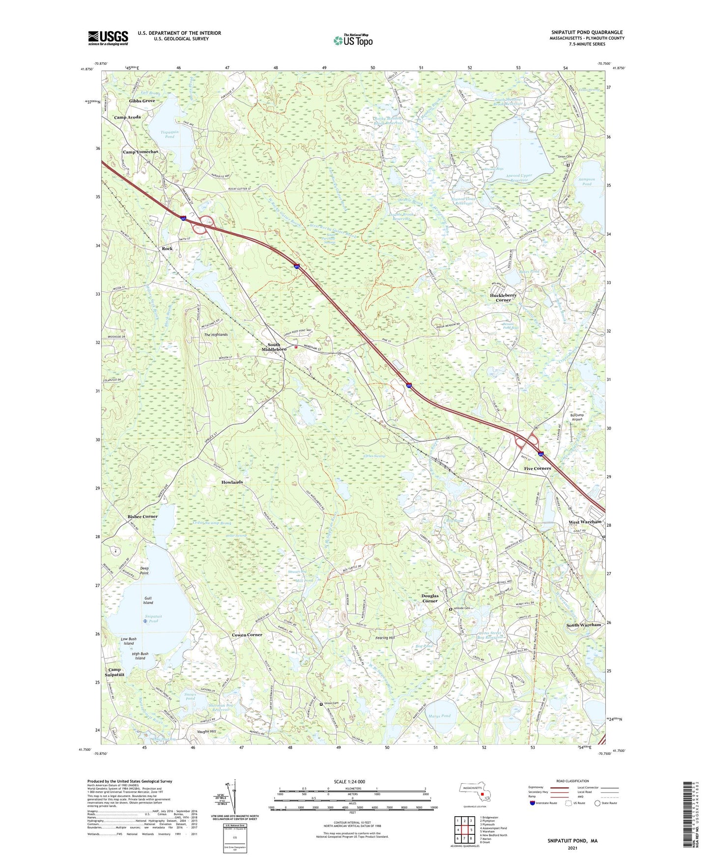
2024 topographic map quadrangle Snipatuit Pond in the state of Massachusetts. Scale: 1:24000. Based on the newly updated USGS 7.5' US Topo map series, this map is in the following counties: Plymouth. The map contains contour data, water features, and other items you are used to seeing on USGS maps, but also has updated roads and other features. This is the next generation of topographic maps. Printed on high-quality waterproof paper with UV fade-resistant inks.
Quads adjacent to this one:
West: Assawompset Pond
Northwest: Bridgewater
North: Plympton
Northeast: Plymouth
East: Wareham
Southeast: Onset
South: Marion
Southwest: New Bedford North
This map covers the same area as the classic USGS quad with code o41070g7.
Contains the following named places: Atwood Bogs, Atwood Lower Reservoir, Atwood Lower Reservoir Dam, Atwood Upper Reservoir, Atwood Upper Reservoir Dam, Bates Pond, Beaverdam Brook, Benson Pond Bogs, Bensons Pond, Big Bearhole Pond, Bisbee Corner, Blackmore Pond, Blackmore Pond East Dam, Blackmore Pond West Dam, Bog Pond, Bulljump Airport, Camp Avoda, Camp Snipatuit, Camp Yomechas, Carver Fire Department Station 3, Cedar Swamp, Cedar Swamp Brook, Cedar Swamp Town Forest, Christ Evangelical Church, Church in the Pines, Continental Can of America Dam A, Cowen Corner, Cranberry Chapel Assembly of God Church, Crane Brook, Cross Street Bog Reservoir, Cross Street Number 2 Dam, Deep Point, Double Brook, Double Brook Dam, Double Brook Reservoir, Douglas Corner, East Branch Sippican River, East Rochester Church, East Rocky Gutter Brook, Edgewood Trust Number 3 Dam, Fearing Hill, Five Corners, Forbes Swamp, France Street Dam, Gibbs Grove, Gibbs Number 2 Dam, Gibbs Number 3 Dam, Gull Island, High Bush Island, Hillside Cemetery, Holmes Street Dam, Howlands, Huckleberry Corner, Indian Brook, Island Air Service Seaplane Base, Leonards Pond, Long Pond, Long Pond Bog, Low Bush Island, Mad Mares Neck, Makepeace Number 1 Dam, Makepeace Number 2 Dam, Marys Pond, Maxim Corner Pond, Middleborough Fire Department Station 2, Mill Pond, Millers Neck Brook, Old Colony Technical High School, Rochester Wildlife Management Area, Rock, Rock Post Office, Rock Station, Rock Village Church, Rocky Gutter Wildlife Area, Rocky Gutter Wildlife Management Area, Rocky Meadow Brook, Rocky Meadow Brook Reservoir, Sampson Pond, Sampson Pond Heliport, Savery Historic District, Sherman Bog Reservoir, Shorts Brook, Slocum - Gibbs Dam Number 2, Slocum - Gibbs Number 1 Dam, Snipatuit Brook, Snipatuit Pond, Snows Pond, South Meadow Brook, South Meadow Brook Reservoir, South Middleboro, South Middleborough Post Office, South Middleborough Station, South Purchase Swamp, Stewart Bog, The Highlands, Tispaquin Pond, Town of Carver, Town of Rochester, Tremont, Tremont Mill Pond, Tremont Mill Pond Dam, Tremont Station, Union Cemetery, Vaughn Hill, Wayne West Heliport, West Branch Sippican River, West Rocky Gutter Brook, West Wareham, West Wareham Census Designated Place, West Wareham Post Office, West Wareham School, Weweantic River Reservoir, Woods Brook, ZIP Codes: 02576, 02770