MyTopo
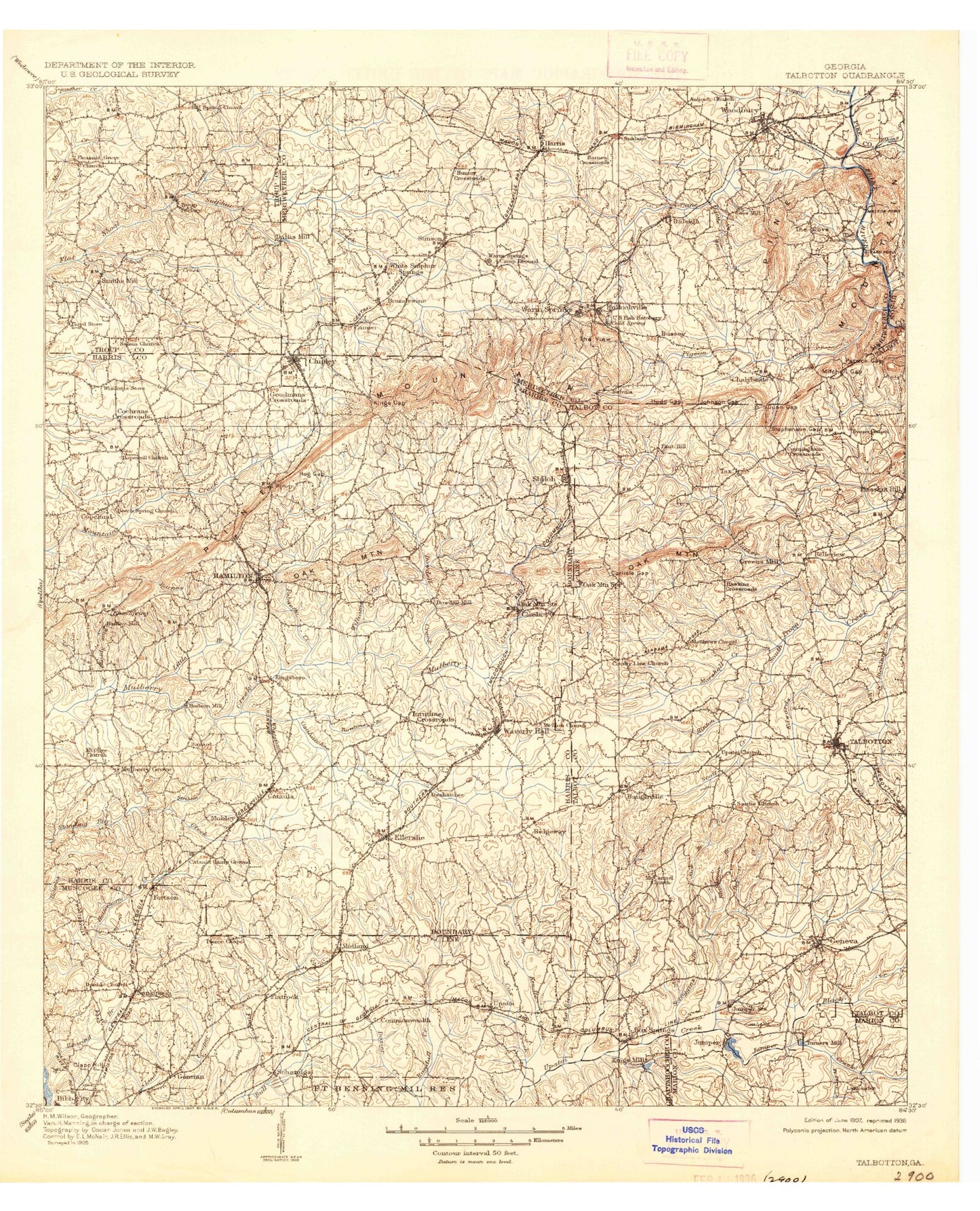
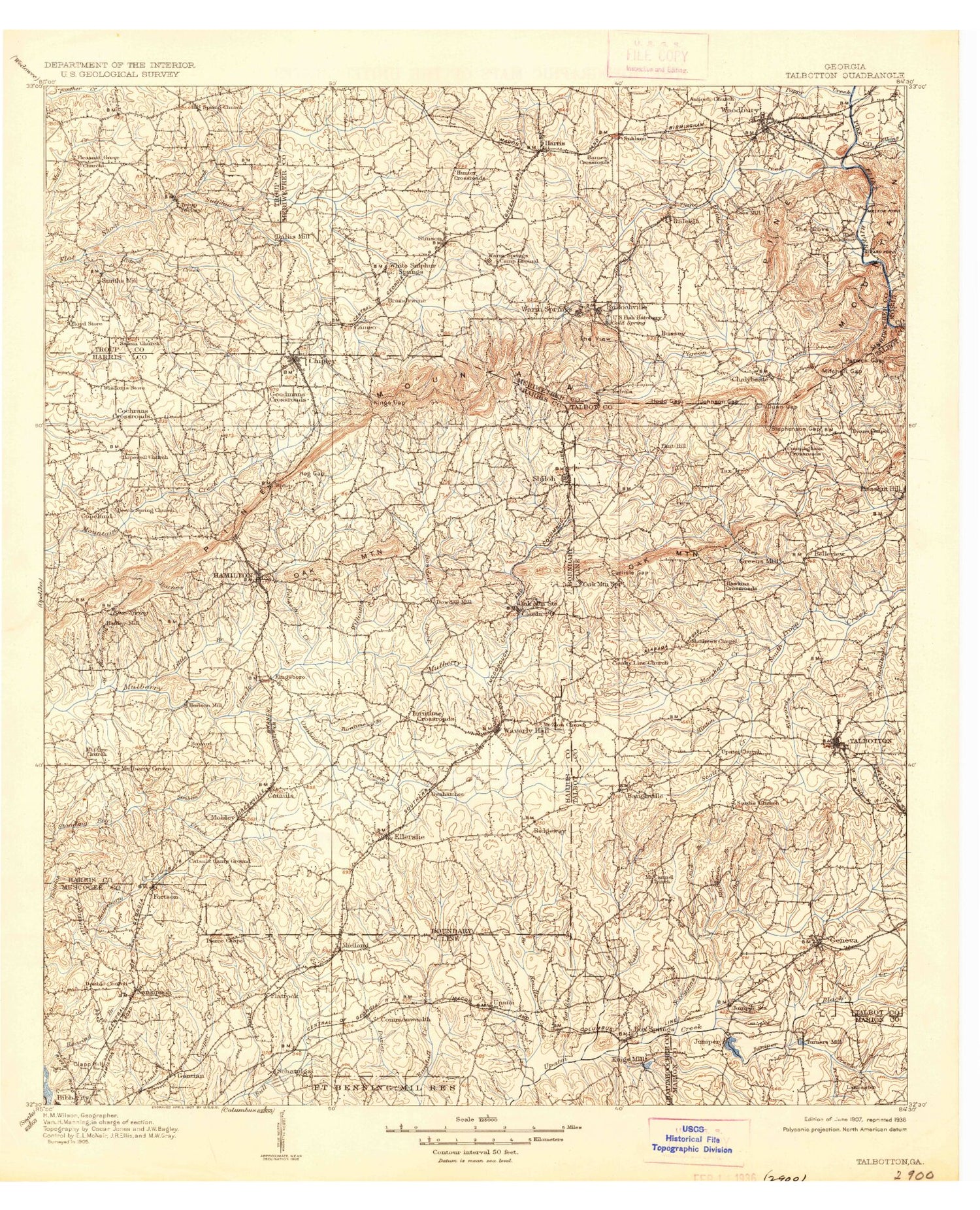
Historic 1907 Talbotton Georgia 30'x30' Topo Map
Couldn't load pickup availability
Historical USGS topographic map of Talbotton in the state of Georgia. Scale: 1:125000. Print size: 17" x 24"
This map was published in 1907 and is in the following counties: Chattahoochee, Harris, Marion, Meriwether, Muscogee, Pike, Russell, Talbot, Troup, Upson.
The map contains contour lines, roads, rivers, towns, streams, and lakes. Printed on high-quality waterproof paper with UV fade-resistant inks.
Contains the following named places: Oliver Dam, Marshall Creek, Allens Lakes, Anthony Lake, Lake Asa, Baker Creek, Barnes Creek, Beaver Creek, Bell Creek, Bethlehem Creek, Black Creek, Blackman Branch, Bluebird Lake, Bobolink Lake, Bonifay Lakes, Boyd Branch, Braketts Lakes, Britton Ponds, Brown Creek, Buck Creek, Bulloch Crossroads, Camp Concharty, Camp McKenzie Boy Scout Camp, Cane Creek, Carlisle Gap, Cascade Branch, Cedar Tree Hollow, Lake Chaplin, Chapman Pease Lake, Cooler Branch, Cooliks Lake, Cooper Branch, Lake Cora, Cox Creek, Crawford Creek, Lake Crystal, Davis Lake, Lake Delano, Double Branch, Dowdell Creek, Dozier Creek, Dripping Rocks, Dry Creek, Dunn Gap, Edwards Creek, Falls Creek Lake, Faulkner Lake, Flatrock Branch, Flatrock Creek, Flatrock Park Lake, Flint Hill, Florence Branch, Fort Creek, Fort Perry Creek, Lake Franklin, Fuller Hollow, Gin Creek, Gin Creek, Ginns Lake, Ginns Old Lake, Grant Creek, Hamilton, Handco Branch, Hardy Branch, Harris Branch, Hawkins Creek, Helm Gap, Hill Lake, Hilyer, Hines Gap, Hinton Branch, Hinton Creek, Hopewell, Hudson Lake, Hudson Mill Rapids, Hummingbird Lake, Hurricane Branch, Lake Ida, Jack Branch, Jacks Creek, James Lake, James Lakes, Joe Grant Branch, Johnson Gap, Jordans Lakes, Juniper Creek, Juniper Creek, Juniper Lake, Juniper Station, Lake Katchanapee, Keenan Hollow, Lake Kick-Ann-Rick, Kings Gap, Kings Mill Creek, Kings Millpond, Knights Branch, Lake Kokoloe, Lake Lorraine, Lake Lucy, Lake Marmosa, Lake Milt-Ann, Lake Olive, Lambs Lake, Linwood Playground, Little Branch, Little Juniper Creek, Little Mountain Creek, Long Branch, Mack Miller Park, Mahone Branch, Manchester, Lake Mary, Matt Branch, McGills Lake, Medleys Pond, Meriwether White Sulphur, Midland, Milen Gap, Mill Creek, Mitchell Gap, Mobleys Lake, Mobleys Pond, Mockingbrid Lake, Mossy Branch, Mount Hope Branch, Muddy Slash Ridge, Muscogee County Flatrock Park, Palmetto Creek, Pappys Creek, Parkman Pond, Patrick Gap, Peeds Lakes, Peoples Branch, Pierce Chapel, Pigeon Creek, Pigpen Hollow, Pine Knoll Lake, Pine Mountain Valley, Lake Pines, Pleasant Valley, Polecat Creek, Porter Creek, Pound Creek, Powell Branch, Ransome Lake, Riley Branch, Robin Lake, Rockhouse Mountain, Rockmore Creek, Rocky Branch, Rocky Ford Branch, Ruckers Lake, Rush Creek, Scott Creek, Scroggins Branch, Sees Old Mill, Sheep Rock Hollow, Lake Somerset, South Fork Upatoi Creek, South Prong Marshall Creek, Sparks Creek, Spring Creek, Spring Head Lake, Stanley Creek, Stephenson Gap, Story Lake, Striblin Creek, Sulphur Creek, Tar River, Tarver Branch, The Cove, Tom Brown Branch, Turkey Creek, Turntime Branch, Turpentine Branch, Upper Falls Creek Lake, Ward Lake, Warm Springs, Warm Springs Branch, Warm Springs Campground, Whetstone Branch, Whippoorwill Lake, White Sulphur Creek, Williams Creek, Willis Lake, Wolfden Branch, Woodland Lake, Wren Lake, Wright Branch, Beall, Hawkins Crossroads, Hunters Crossroad, Johnson Crossroads, Mountainbrook, Oak Grove, Oak Mountain, Ridgeway, Routons Crossroads, Smiths Crossroads, Smiths Mill, Turntime Crossroads, Harris County, Talbot County, Allendale, Andrews Crossroads, Barnes Crossroads, Baughville, Betts, Betts Mountain, Buzzard Roost, Caroline Park, Cascade Hills, Cataula, Crowders Crossing, Crystal Valley, Dixon Mountain, Ellerslie, Gentian, Glenns, Goat Mountain, Greens Mill, Highland Pines, Huckleberry Pinnacle, Juniper, Kingsboro, Langdon, Laurel Hills, Lincoln Hills, Loftin, Lyn Hills, McLendon Crossroads, Mulberry Grove, Nankipooh, Nebula, Oak Grove, Oak Mountain