
Design your custom map
In 15 minutes or less, we'll make the perfect map for you.
Pricing of custom maps varies on size and base map choice, but start as low as $22.95. Sessions typically last 15 minutes or less. Maps are printed and shipped in 24 hours.
Find the location of your map using our search page, preview the basic options, then (if the preview isn't perfect, or you want a specialized option) please book a map making session for one of our specialists to "meet" you online to finalize a custom map. During an online map making session, ALL options and map types are available including scale, grids, size, paper type, land ownership (private and public), bathymetric underwater contours, aerial photographs, hybrid maps, and of course, seamless USGS topographic maps.
Getting Started
We highly recommend using our map-based search page to locate where your would like your map. Then select the Custom Map option, fill out a brief questionnaire to provide some details, then - if the perfect map doesn't already show in the preview - schedule an appointment to finalize your custom map.
Next Step
Once you have determined the location of your map, and filled out the questionnaire, please schedule an appointment to finalize your map. Unless a map appointment is scheduled and completed, your map can not be created, paid for, or shipped. This allows us to be certain that the map we create for you will be perfect for your needs.
If for whatever reason the map search or questionnaire is not helpful to you, no worries! Just schedule an appointment and we'll be happy to make the perfect map with you at that time.
Couldn't load pickup availability
To book a map-making session, click "Schedule an appointment" and pick a date/time. Then "Book Now", enter your contact information (email address is required) and confirm your free, no-obligation appointment.
Important Instructions
Upon confirmation, you will receive an email with a link to the online meeting. Please click that link during the appointed time slot to work with a mapping specialist to create your map. A working audio/video (teleconferencing) setup is required.
If you do not receive the confirmation email, then your appointment was not completed. Please pick a different time and try again.
Appointment slots are limited and only available at the times indicated. Alternatively, please see the instructions on how to use our professional-grade map making PC software for free to make your own custom map.
What are the possibilities?
Aerial/Satellite Map:
We have satellite/aerial image maps available from within the last three years for over 95% of the US.
Canadian Topo Maps:
We have topography maps at the scales of 1:35,000, 1:50,000, 1:63,000 and 1:75,000 for all Canadian provinces
Private Land Overlays:
We can overlay private property boundaries with owner’s name or APN number on topographic and/or satellite maps
Laminated Maps:
Need to be able to write on the maps with a dry erase marker or grease pen? We can make a laminated map for you.
Banner Maps:
We can print up to 5 ft x 8 ft maps. These make great wall decorations for cabins, hunting camps, lodges, etc.
Anywhere Maps:
Maps centered on a specific address or grid coordinate.
Military Maps:
MGRS Maps printed at 1:50,000 or 1:25,000 scale with MGRS grid overlay
Public Land Maps:
Maps centered on any Wildlife Management Area, State Forest, Park, State Game Lands, etc.
----
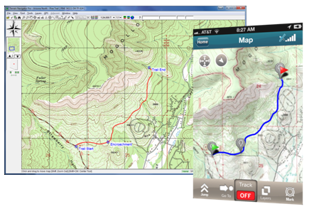
Make Your Own Map
Rather do it yourself?
We provide free access to our award-winning PC mapping software, Terrain Navigator Pro. Use TNP to design your perfect map, then upload it to MyTopo to be printed on our waterproof paper using UV-resistant inks!
Use of TNP for the purpose is FREE and without any obligation to purchase a subscription.