
MyTopo
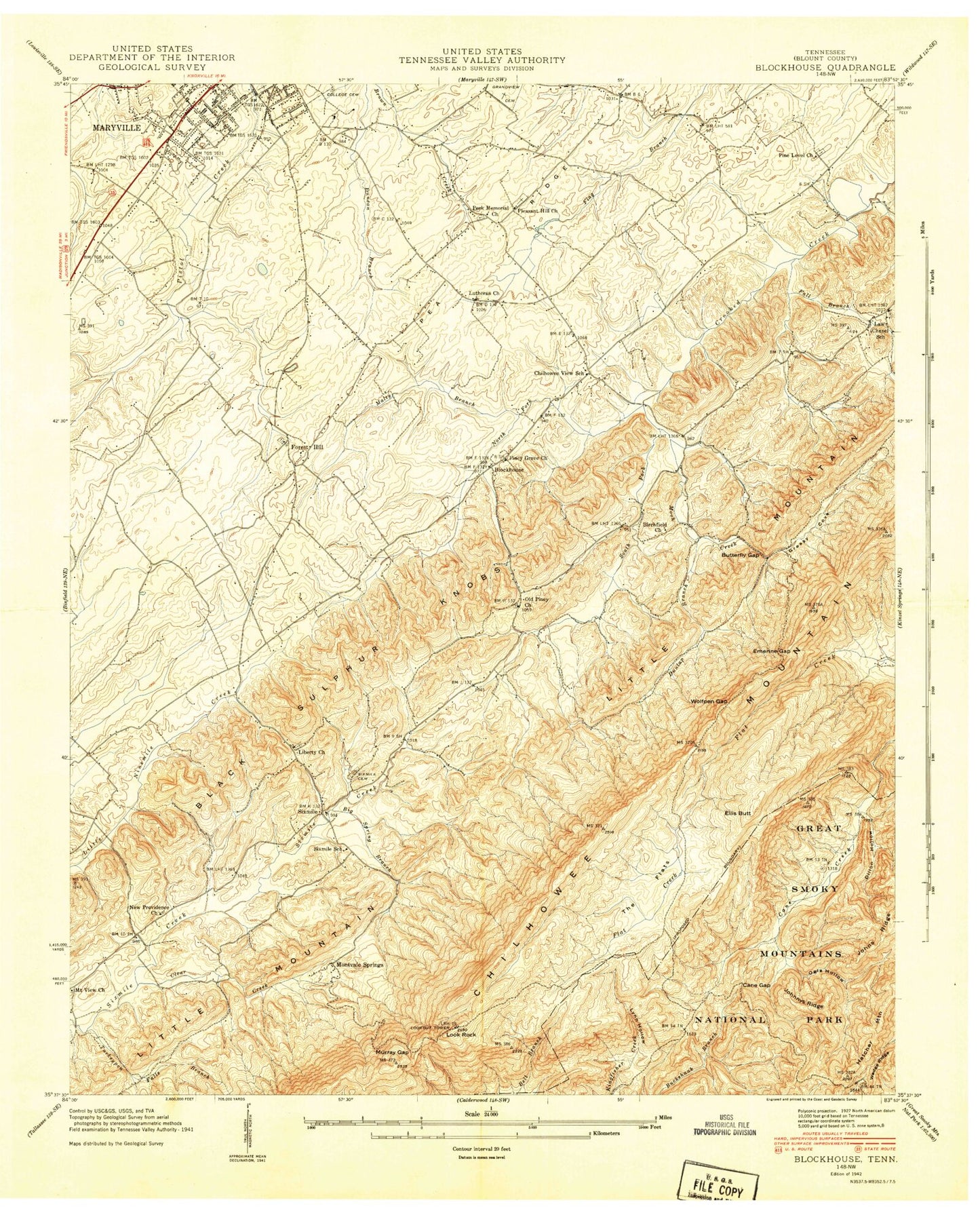
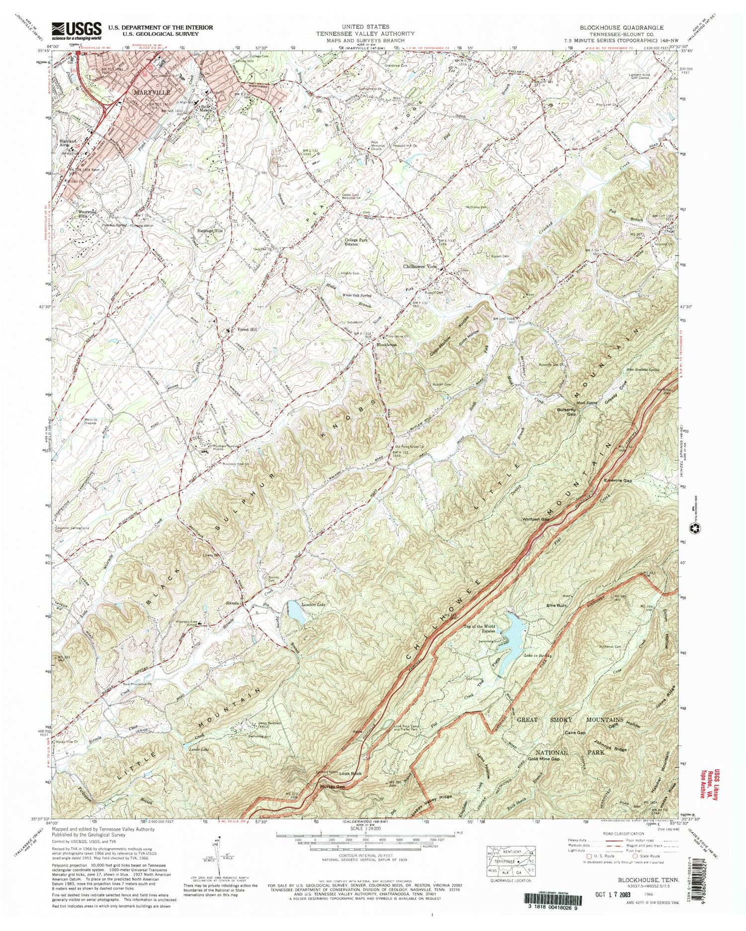
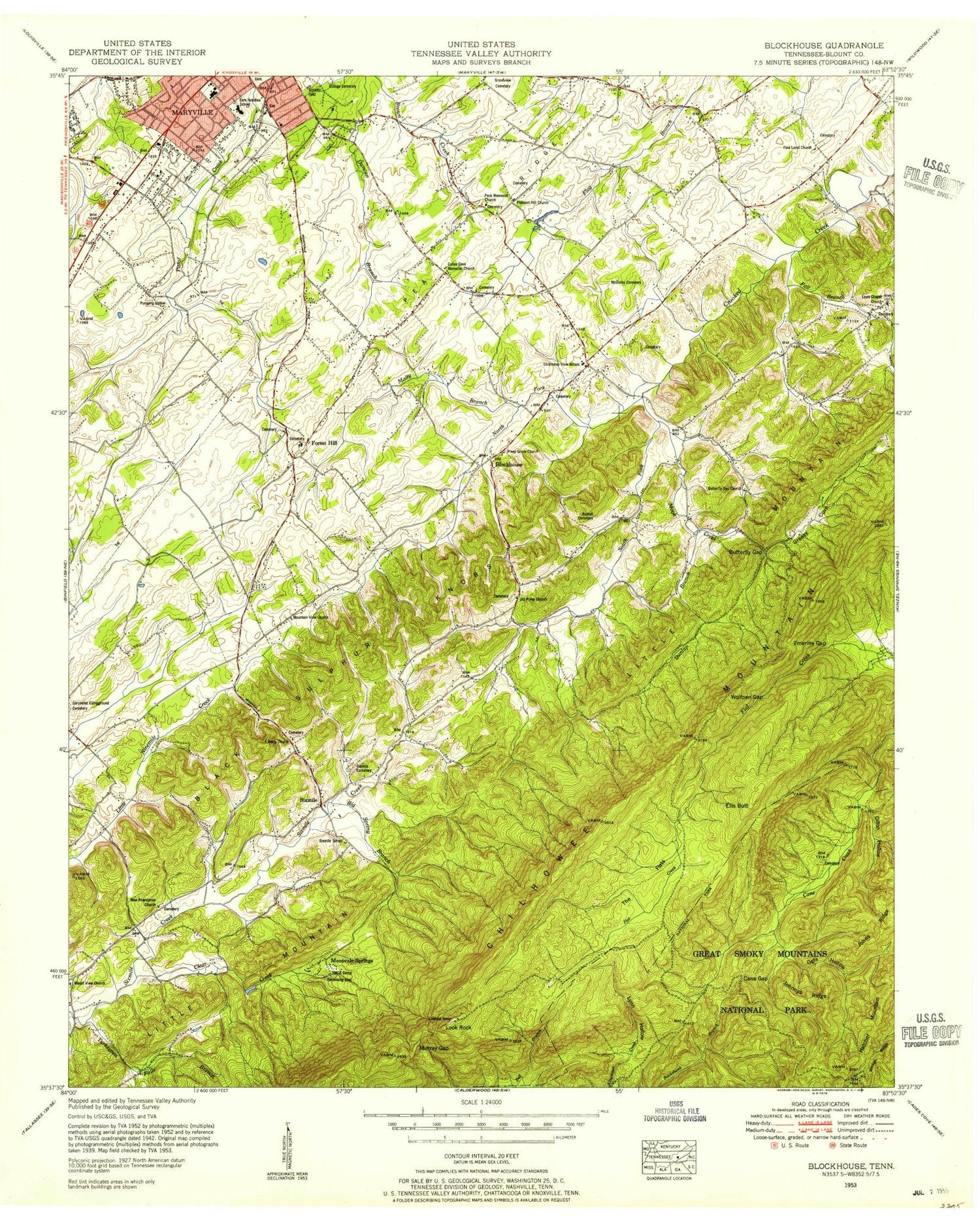
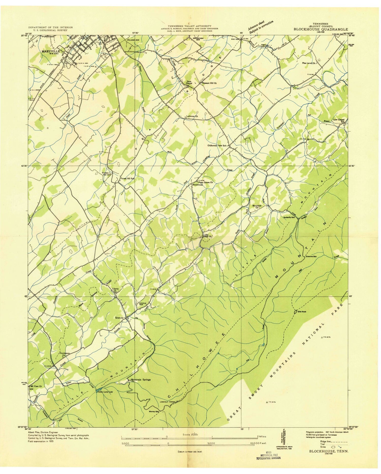
Classic USGS Blockhouse Tennessee 7.5'x7.5' Topo Map
Couldn't load pickup availability
Historical USGS topographic quad map of Blockhouse in the state of Tennessee. Typical map scale is 1:24,000, but may vary for certain years, if available. Print size: 24" x 27"
This quadrangle is in the following counties: Blount.
The map contains contour lines, roads, rivers, towns, and lakes. Printed on high-quality waterproof paper with UV fade-resistant inks, and shipped rolled.
Contains the following named places: Fall Branch, Pea Ridge, Simerly Cemetery, Lake in the Sky, South Fork Crooked Creek, The Flats, Top of the World Estates, Turkeypen Branch, Twin Oak Church, Victory Church, White Oak Spring, Wolfpen Gap, Big Spring Branch, Black Sulphur Knobs, Blockhouse, Buchanan Family Cemetery, Butterfly Gap, Butterfly Gap Church, Cades Cove Memorial Church, Camp Montvale, Cane Gap, Chilhowee View, Clear Creek, Coon Hollow, Coon Hollow Knobs, Dillon Hollow, Dunlap Branch, Ellis Butt, Emerine Gap, Forest Hill, Gethsemane Church, Gold Mine Gap, Greasy Cove, Happy Valley Ridge, Heritage Hills, Highland Acres, Hillcrest Church, Hise Roulette Spring, Johnnys Ridge, Johns Ridge, Lambert Acres Golf Course, Lambert Lake, Lanier Lake, Laws Chapel Baptist Church, Liberty Church, Look Rock, Look Rock Campground, Lynn Hollow, Malty Branch, Maryville Dragway, McGinley Cemetery, Miller Cove, Monte Vista Baptist Church, Montvale Nursing Homes, Mook Creek, Mook Spring, Mount View Church, Mountain View Church, Mountain View School, Murray Gap, New Providence Primitive Baptist Church, North Fork Crooked Creek, Ogle Hollow, Old Piney Grove Church, Pearson Spring, Peck Memorial Church, Pine Level Church, Piney Grove Church, Pleasant Hill Church, Russell Cemetery, Russell Cemetery, Russell Cemetery, Saint Paul Church, Sandy Stand Lake, Sandy Stand Dam, Sixmile, Six Mile Cemetery, Westwood Hills, Belle Meade, College Cemetery, College Park Estates, Lake in the Sky Dam, Lambert Dam, Montvale Springs, Sixmile School (historical), Chilhowee View School, Chelsey Village, Oaklawn Addition, Creekwood, Eastover, Law Chapel, Law Chapel School (historical), South View Estates, East Forest, Montvale, Montvale Elementary School, Forest Hill Elementary School, Oxford Hills, Wimbledon, Montvue, Turnberry Vistas, Briarcliff, Tee Lee Heights, Buena Vista, Lonas Addition, Foothills Mall Shopping Center, Foothills Plaza Shopping Center, Sunset View, Sherwood Forest, Willard Addition, Maryville High School, Mountain View Addition, Sandy Springs Park, Maryville Middle School, Windsor Park, Cane School (historical), Foothills Parkway, Little Mountain, Blount County, Lutheran Cemetery, New Providence Primitive Baptist Cemetery, Old Piney Grove Cemetery, Pecks Chapel Cemetery, Piney Level Cemetery, Pleasant Hill Cemetery, Maryville Polytechnic School (historical), Freedmans Institute (historical), Laws Chapel Cemetery, Liberty Cemetery, Montvale Springs, Six Mile Baptist Church, Blacks Fort (historical), Saint Johns Lutheran Church, Whites Mill, Cavins Fort (historical), Forest Hill Baptist Church, Forest Hill Cemetery, Forest Hill Presbyterian Church (historical), Second Presbyterian Church, Shields Stadium, Sam Houston Elementary School, Maryville Post Office, Cane creek Campsite, City of Maryville, Commissioner District 4, Commissioner District 5, Blount County Fire Protection District Station 1, Maryville Fire Department Station 3, Montvale Airpark, Lail Cemetery, Fall Branch, Pea Ridge, Simerly Cemetery, Lake in the Sky, South Fork Crooked Creek, The Flats, Top of the World Estates, Turkeypen Branch, Twin Oak Church, Victory Church, White Oak Spring, Wolfpen Gap, Big Spring Branch, Black Sulphur Knobs, Blockhouse, Buchanan Family Cemetery, Butterfly Gap, Butterfly Gap Church, Cades Cove Memorial Church, Camp Montvale, Cane Gap, Chilhowee View, Clear Creek, Coon Hollow, Coon Hollow Knobs, Dillon Hollow, Dunlap Branch, Ellis Butt, Emerine Gap, Forest Hill, Gethsemane Church, Gold Mine Gap, Greasy Cove, Happy Valley Ridge, Heritage Hills, Highland Acres, Hillcrest Church, Hise Roulette Spring, Johnnys Ridge, Johns Ridge, Lambert Acres Golf Course, Lambert Lake, Lanier Lake, Laws Chapel Baptist Church, Liberty Church, Look Rock, Look Rock Campground, Lynn Hollow, Malty Branch, Maryville Dragway, McGinley Cemetery, Miller Cove, Monte Vista Baptist Church, Montvale Nursing Homes, Mook Creek, Mook Spring, Mount View Church, Mountain View Church, Mountain View School, Murray Gap, New Providence Primitive Baptist Church, North Fork Crooked Creek, Ogle Hollow, Old Piney Grove Church, Pearson Spring, Peck Memorial Church, Pine Level Church, Piney Grove Church, Pleasant Hill Church, Russell Cemetery, Russell Cemetery, Russell Cemetery, Saint Paul Church, Sandy Stand Lake, Sandy Stand Dam, Sixmile, Six Mile Cemetery, Westwood Hills, Belle Meade, College Cemetery, College Park Estates, Lake in the Sky Dam, Lambert Dam, Montvale Springs, Sixmile School (historical), Chilhowee View School