MyTopo
Classic USGS McDonald Tennessee 7.5'x7.5' Topo Map
Couldn't load pickup availability
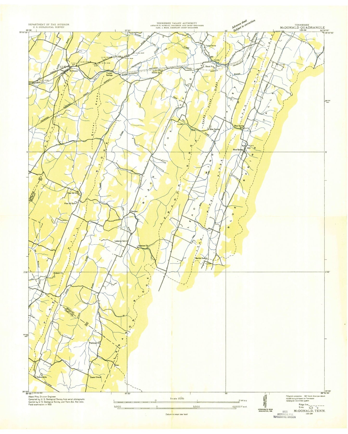
Historical USGS topographic quad map of McDonald in the state of Tennessee. Map scale may vary for some years, but is generally around 1:24,000. Print size is approximately 24" x 27"
This quadrangle is in the following counties: Bradley, Hamilton.
The map contains contour lines, roads, rivers, towns, and lakes. Printed on high-quality waterproof paper with UV fade-resistant inks, and shipped rolled.
Contains the following named places: Allen Branch, Antioch Baptist Church, Antioch Baptist Church Cemetery, Bethea Pond, Bethel Baptist Church, Bethel Cemetery, Black Fox, Black Fox Creek, Black Fox Methodist Church, Black Fox Mine, Black Fox School, Black Fox Valley, Blue Springs, Blue Springs Baptist Church, Blue Springs Branch, Blue Springs Cemetery, Blue Springs Elementary School, Blue Springs Ridge, Blue Springs Valley, Bradley County Fire and Rescue Station 3 - Maroon Branch, Bradley County Fire and Rescue Station 4 - McDonald, Brown Spring, Brymer Creek, Butler Knobs, Commissioner District 6, Corinth Church, Cross Spring, D A M Mine, Davis Lake, Davis Lake Dam, Dockery, Drumgool Creek, Dry Creek, Eads Spring, East View, Finnel Spring, Flint Springs, Flint Springs Academy, Flint Springs Cumberland Presbyterian Church Cemetery, Flint Springs Presbyterian Church, Flint Springs School, Goats Chapel, Grant Spring, Green Meadow, Green Spring, Hambright Cemetery, Hambright Mine, Hannah Prospect, Hardwick Mine, Hickory Top, Hidden Valley Camp, Hidden Valley Dam, Hidden Valley Lake, Hidden Valley Spring, Higgins Springs, Howardville, Hungry Hollow, Hysinger Spring, Jerry Johnson Spring, Johns Cemetery, Johnson Knob, Johnston Lake Dam Number One, Johnston Ponds, Johnston Spring, Jones Prospect, Kelley Cemetery, Lead Mine Ridge, Lead Mine Valley, Lebanon, Lebanon Cemetery, Lebanon Church, Lebanon Ridge, Lebanon School, Lee Cemetery, Loftis Cemetery, Lord Mine, Lusk Cemetery, Marble Switch, Marcone School, Maroon Branch, Maroon Gap, Maroon School, Maroon Valley, McDonald, McDonald Census Designated Place, McDonald Elementary School, McDonald Post Office, McKamey Cemetery, McKay Spring, Moore Spring, Moss Spring, Mount Carmel Baptist Church, Mount Carmel Community Cemetery, Oklahoma Cemetery, Parks Store, Philadelphia Church, Phillips Branch, Phillips Cemetery, Pine Hill, Pine Hill Cemetery, Pine Hill Church of God, Pine Hill Presbyterian Church, Pine Hill Ridge, Pine Hill School, Quarry Knob, Red Hill, Red Hill Cemetery, Red Hill Lookout Tower, Red Hill Methodist Church, Red HIll School, Red Hill Valley, Red Hills, Rymer Spring, Sloan Gap, Sloan Prospect, Smith Ridge, Smiths Mill, Snyder Gap, Snyder Prospect, South Bradley Division, South Cleveland Census Designated Place, Sugarloaf Knob, Sweet Gap, Sweet Hill, Taylor Branch, Taylor Cemetery, Taylor Spring, Timber Hills, Triplett Cemetery, Triplett Spring, Tucker Cemetery, Tucker Springs, Vaughan Spring, Weatherly Switch, Wesley Ann Cemetery, Wesleyann Church, Whites Cut Ridge, ZIP Codes: 37311, 37353