MyTopo
Beaufort South Carolina US Topo Map
Couldn't load pickup availability
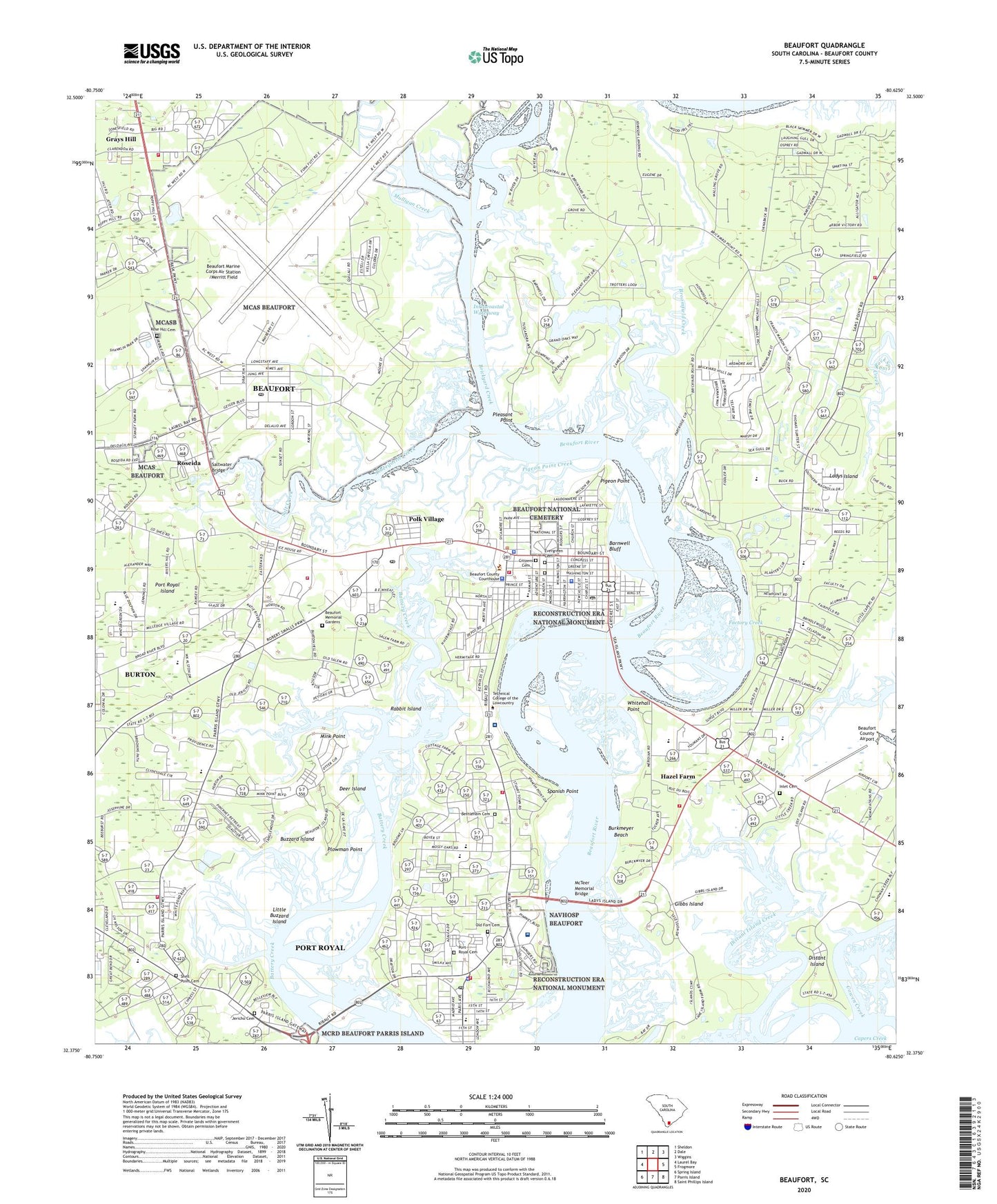
2020 topographic map quadrangle Beaufort in the state of South Carolina. Scale: 1:24000. Based on the newly updated USGS 7.5' US Topo map series, this map is in the following counties: Beaufort. The map contains contour data, water features, and other items you are used to seeing on USGS maps, but also has updated roads and other features. This is the next generation of topographic maps. Printed on high-quality waterproof paper with UV fade-resistant inks.
Quads adjacent to this one:
West: Laurel Bay
Northwest: Sheldon
North: Dale
Northeast: Wiggins
East: Frogmore
Southeast: Saint Phillips Island
South: Parris Island
Southwest: Spring Island
Contains the following named places: Academy Estates, Albergottie Creek, Arthur Horne Nature Park, Ashdale School, Attaway, Barnwell Bluff, Barnwell School, Battery Creek High School, Battery Marina Village, Beaufort, Beaufort Academy, Beaufort Artillery Arsenal, Beaufort Baptist Church, Beaufort Business Center, Beaufort City Hall, Beaufort College, Beaufort County Airport, Beaufort County Courthouse, Beaufort County Emergency Management Division, Beaufort County Emergency Medical Services, Beaufort County Jail, Beaufort County Library Main Branch, Beaufort County Memorial Hospital Heliport, Beaufort County School District Adult Education Center, Beaufort County Sheriff's Office, Beaufort County Training School, Beaufort Elementary School, Beaufort Fire Department Station, Beaufort Fire Department Station 2, Beaufort High School, Beaufort Historic District, Beaufort Marine Corps Air Station /Merritt Field, Beaufort Memorial Ambulatory Surgery Center, Beaufort Memorial Gardens, Beaufort Memorial Hospital, Beaufort Middle School, Beaufort National Cemetery, Beaufort Plaza Shopping Center, Beaufort Police Department, Beaufort Police Department District A Substation, Beaufort Post Office, Beaufort Township Library, Beaufort Village Industrial Park, Beaufort Yacht Club, Beaufort-Port Royal Division, Beth Israel Cemetery, Beth Israel Synagogue, Bethel African Methodist Episcopal Church, Bethlehem Cemetery, Blue Heron Bluff, Bluff Farm, Bon Aire, Brickyard Creek, Brickyard Plantation, Brickyard Point Plantation, Broomfield Church, Broomfield Creek, Burkmeyer Beach, Burton, Burton Census Designated Place, Burton Fire Department - Headquarters Station 1, Burton Fire Department Grays Hill Station 892, Burton Fire District - Shell Point Station 893, Burton Post Office, Buzzard Island, Calhoun Thomas Memorial Gardens, Calvary Church, Carteret Street United Methodist Church, Cat Island Golf Club, Central Baptist Church, Cherry Hill Estates, Cherry Hill Plantation, Christ Our Lord Episcopal Church, Citizens Cemetery, City of Beaufort, Colonial Heights, Colony Gardens Estates, Coosa Elementary School, Country Club Bluff, Country Club of Beaufort at Pleasant Point, Cross Creek Shopping Center, Crystal Lake, Daniels, Deer Island, Distant Island, Distant Island Creek, Dowlingwood, Elliott House Museum, Eustis School, Evergreen Cemetery, Factory Creek, First African Baptist Church, First Christian Church of Shell Point, First Presbyterian Church, Forest Fields, Fort Lyttleton, Gay Oaks, Gibbs Island, Grace Bethel African Methodist Episcopal Church, Grays Hill, Grays Hill Church, Green Pond, Hazel Farm, Highway 170 Church of Christ, Huspah Church, Inlet Cemetery, Island Square Shopping Center, Israelite Church, James Byrnes Estates, Jean Ribaut Square Shopping Center, Jericho Cemetery, Jericho Church, Jericho School, Jordan Church, Ladies Island Church, Ladys Island, Lady's Island - Saint Helena Fire District Station 20, Lady's Island - Saint Helena Fire District Station 21, Ladys Island Country Club, Lady's Island Elementary School, Ladys Island Marina, Lady's Island Middle School, Ladys Island Shopping Center, Lawson Temple, Little Buzzard Island, Lucy Creek, Magnolia Bluff, Marine Corps Air Station Beaufort, Mariners Watch, Mark Island, Marsh Harbor, Marsh Hawk, Mather School, McTeer Memorial Bridge, Mink Point, Mink Point Plantation, Morgan River Estates, Morningside of Beaufort, Mossy Oaks Elementary School, Mulligan Creek, Naval Air Station Beaufort, Naval Hospital at Beaufort, Naval Hospital Beaufort, New Hope Church, Oakwood Park, Old Fort Cemetery, Old Fort Church, Orange Grove, Palmetto Estates, Park University - Beaufort - Marine Corps Air Station, Parris Island Golf Course, Partridge Woods, Peace Haven, Pepper Hill, Pigeon Point, Pigeon Point Creek, Pine Hill Acres, Pleasant Point, Plowman Point, Polk Village, Port Royal, Port Royal Baptist Church, Port Royal Cemetery, Port Royal City Hall, Port Royal Elementary School, Port Royal Fire Department, Port Royal Island, Port Royal Landing, Port Royal Landing Marina, Port Royal Police Department, Port Royal Post Office, Port Royal United Methodist Church, Porter Chapel, Praise Assembly Church, Praise Christian Academy, Quail Run, Rabbit Island, Reconstruction Era National Monument, Red Bluff Estates, Red Oak, Retreat Plantation, Rivers Edge, Riverwind, Robert Smalls High School, Robert Smalls Middle School, Rose Hill Cemetery, Roseida, Royal Oaks Shopping Center, Royal Pines Country Club Estates, Saint Johns Church, Saint Paul School, Salem Plantation, Salt Creek, Saltwater Bridge, Sangster Village, Shammy Landing, Shell Point, Shell Point Cemetery, Shell Point Elementary School, Shell Point park, Sherwood Forest, South Carolina Department of Public Safety, South Carolina Highway Patrol, South Carolina Noname 07005 D-2933 Dam, Spanish Point, Springfield, Summit Place of Beaufort, Tanglewood, Technical College of Low Country, The Church of Jesus Christ of Latter Day Saints, Union Church, United States Naval Hospital Beaufort, University of South Carolina - Beaufort Campus, University of South Carolina at Beaufort North Campus Barnwell House, University of South Carolina at Beaufort North Campus Beaufort College, University of South Carolina at Beaufort North Campus Elliott House, University of South Carolina at Beaufort North Campus Grayson Faculty House, University of South Carolina at Beaufort North Campus Hamilton House, University of South Carolina at Beaufort North Campus Performing Arts Center, University of South Carolina at Beaufort North Campus Science Building, US Marshals Service, Verdier House Museum, WAGP-FM (Beaufort), Walling Grove, Walnut Hill, Walsh, Waterford Place, Waterfront Park, WBEU-AM (Beaufort), Webster University, Whitehall Point, WVGB-AM (Beaufort), Yacht Club Estates, ZIP Codes: 29904, 29935