MyTopo
Laurel Maryland US Topo Map
Couldn't load pickup availability
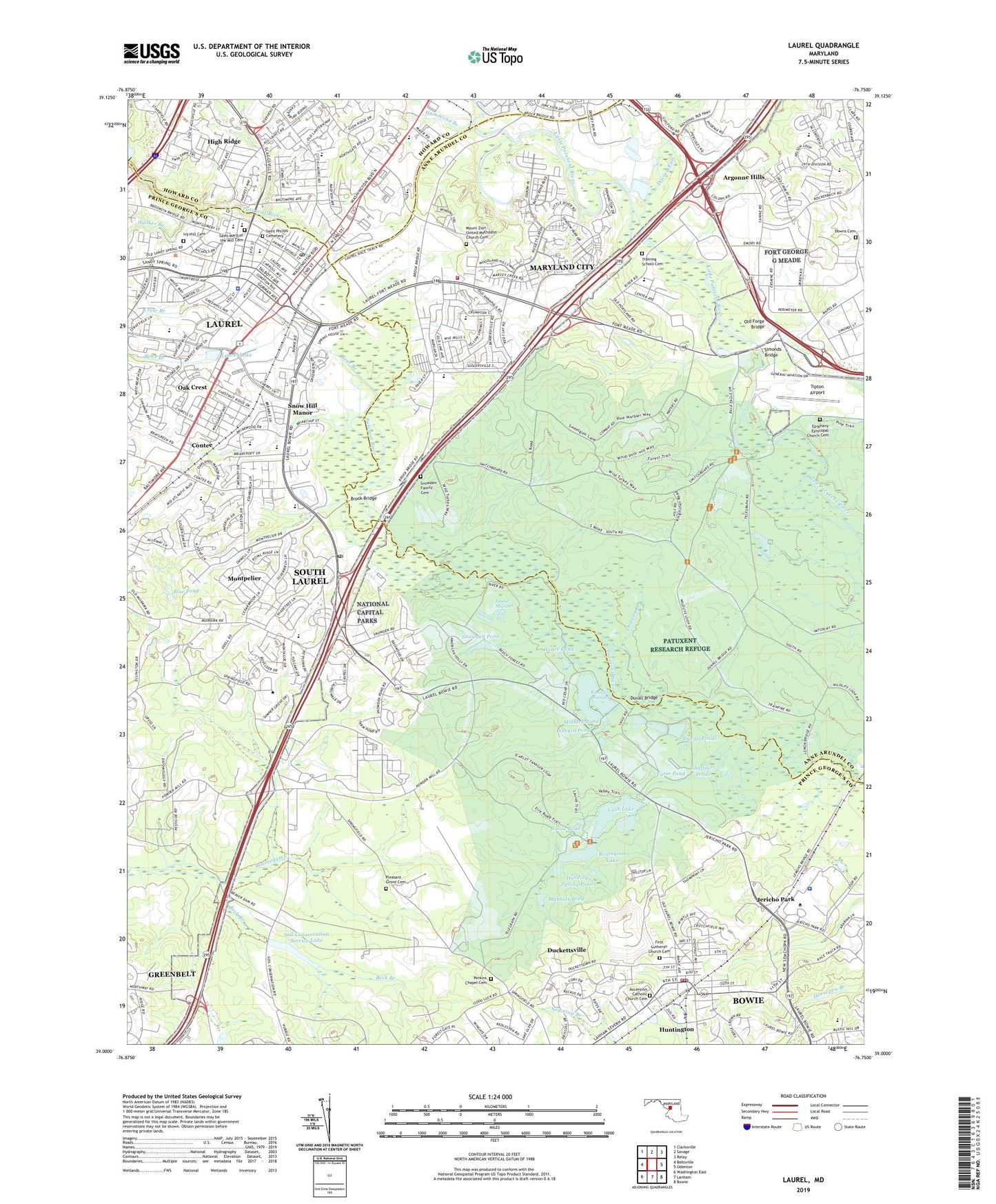
2019 topographic map quadrangle Laurel in the state of Maryland. Scale: 1:24000. Based on the newly updated USGS 7.5' US Topo map series, this map is in the following counties: Prince George's, Anne Arundel, Howard. The map contains contour data, water features, and other items you are used to seeing on USGS maps, but also has updated roads and other features. This is the next generation of topographic maps. Printed on high-quality waterproof paper with UV fade-resistant inks.
Quads adjacent to this one:
West: Beltsville
Northwest: Clarksville
North: Savage
Northeast: Relay
East: Odenton
Southeast: Bowie
South: Lanham
Southwest: Washington East
Contains the following named places: Alex Haley Residence Hall, All Saints Church, Argonne Hills, Arnold Volunteer Fire Department, Arundel Gateway Business Park, Ascension Catholic Church Cemetery, Ascension Church, Ascension Day Care and Kindergarten, Avondale Industrial Area, Avondale School, Avrum Gudelsky Memorial Auditorium, Bacontown Recreation Area, Baltimore - Washington Parkway, Barbersville Trailer Park, Bear Branch, Beck Branch, Bedford Park, Beech Crest Mobile Estates, Beltsville Naval Outer Landing Field, Benjamin Franklin Hall, Birchwood Gardens, Blue Pond, Blue Ponds Park, Bluegill Pond, Bowie Montessori Children's House, Bowie State University, Bowie State University Campus Police Department, Bowie Volunteer Fire Department Station 819, Bray Green Industrial Park, Briarwood, Brock Bridge, Brock Bridge Elementary School, Canterbury Riding, Capitol College, Cash Creek Dam, Cash Creek Lake, Cash Lake, Center for Learning & Technology, Charles Steinmetz Hall, Charlotte Robinson Hall, Cherry Lane Nursing Center, Church of God in Christ, City of Laurel, Colony Fairfield, Contee, Corridor Marketplace Shopping Center, Crow Branch, Davis Industrial Park, Deerfield Run Elementary School, District 10 Laurel, District 14 Bowie, District of Columbia Childrens Center, Dorsey Run, Downs Cemetery, Duckettsville, Duvall Bridge, Duvall Ponds, Dwight D Eisenhower Middle School, Dwight Holmes Residence Hall, Edmonston School, Epiphany Episcopal Church Cemetery, Faith Baptist Christian School, Farm Pond, First Baptist School of Laurel, First Lutheran Church Cemetery, Fort Meade Golf Course, Fox Rest, George Crawford Science Building, Glenn Dale United Methodist Church, Goddard Space Flight Center, Goodloe Apartments, Goodloe House, Goose Pond, Gorman Shopping Center, Grove School, Hall Park, Hammond Branch, Hance Pond, Harding Spring Pond, Harriet Tubman Residence Hall, Hicks Mill, High Ridge, High Ridge Park, Huntington, Huntington North Recreation Area, Huntington South, Huntington South Recreation Area, Island Marshes, Ivy Hill Cemetery, James H Harrison Elementary School, Jericho Park, John G and Beverly A Puente Library, Junction Industrial Park, Kiddie Academy of Laurel, Knowles Marshes, Larchdale Park, Laurel, Laurel Branch Library, Laurel Branch Prince George's County Memorial Library, Laurel Centre Mall Shopping Center, Laurel College Center, Laurel Commons Post Office, Laurel Elementary School, Laurel High School, Laurel Junior High School, Laurel Lake, Laurel Lakes Shopping Center, Laurel Municipal Center, Laurel Pines Country Club, Laurel Plaza Shopping Center, Laurel Police Department, Laurel Post Office, Laurel Racetrack, Laurel Shopping Center, Laurel Volunteer Rescue Squad Station 849, Laurel Wood, Laurel Woods Elementary School, Lee DeForest Hall, Lemons Bridge, Leonidas James Physical Education Complex, Lucretia Kennard Residence Hall, M/A-COM Hall, Mabbott Pond, Maier Industrial Park, Mallard Pond, Maple Glen School, Martin Luther King Junior Communications Arts Center, Maryland City, Maryland City Branch Library, Maryland City Census Designated Place, Maryland City Elementary School, Maryland City Park, Maryland City Plaza Shopping Center, Maryland City Volunteer Fire Department Company 27, MCI Hall, Midway Mobile Home Park, Mistletoe Springs, Montessori School of North Laurel, Montpelier, Montpelier Cultural Arts Center, Montpelier Elementary School, Montpelier Forest, Montpelier Hills, Montpelier Mansion, Montpelier Post Office, Montpelier Woods, Mount Zion Methodist Church, Mount Zion United Methodist Church Cemetery, Mowatt Memorial Church, Muirkirk Park, National Business Park, National Capital Parks, National Cryptologic Museum, North Creek Farms, North Laurel Park, North Ridge, Northgate Woods, Oak Crest, Oak Hill Academy, Oaklands Elementary School, Old Forge Bridge, Oxford Green, Pallotti Day Care Center, Pallotti High School, Patuxant Greens Country Club, Patuxent Research Refuge, Patuxent Riding, Perkins Chapel, Perkins Chapel Cemetery, Perkins Memorial, Pershing Hill Elementary School, Pfister Mobile Home Park, Phair School, Pheasant Run, Pheasant Run Community Park, Phillips Laurel School, Pines of Laurel, Pleasant Grove Cemetery, Pleasant Run Shopping Center, Portland Station, President's House - Bowie State University, Redington Lake, Redington Lake Dam, Robinson Laboratory School, Route 32 Business Center, Saint Mary of the Mill Cemetery, Saint Marys School, Saint Philips Cemetery, Sandy Hill Acres, Sandy Hill Neighborhood Park, Savage Station, Savage Switch, Science Building - Bowie State University, Settlers Landing, Shaffners Ponds, Simonds Bridge, Smuel Morse Hall, Snow Hill Manor, Snow Hill Manor Neighborhood Park, Snowden Family Cemetery, Snowden Pond, Snowdens Birmingham Manor, Soil Conservation Service Lake, Soil Conservation Service Lake Dam, South Laurel, South Laurel Census Designated Place, South Laurel Neighborhood Park, Steward Manor, Suburban Airport, Theodore McKeldin Gymnasium, Thomas Branch, Thomas Edison Hall, Thurgood G Marshall Library, Tipton Airport, Towers Residence Hall, Town and Country, Training School Cemetery, United States Department of the Interior Patuxent Wildlife Research Center, Villages of Montpelier, Walker Branch, Walter Reed Medical Center Farm, Waxters Childrens Center, Welshs Mobile Home Park, West Bowie Post Office, West Meade Early Education Center, Whiskey Bottom Industrial Park, Whiskey Bottom Road Elementary School, WILC-AM (Laurel), William E Henry Administration Building, William G McGowan Academic Center, Willis Pumping Station, Wiseman University Center, Zigler Elementary School, ZIP Codes: 20708, 20724