MyTopo
Canyonlands Wall Map (Canyonlands NP, Utah)
Couldn't load pickup availability
A special Backpacker Magazine topo map printed on waterproof, tearproof paper. Includes topographic map data from the USGS and detailed trip information
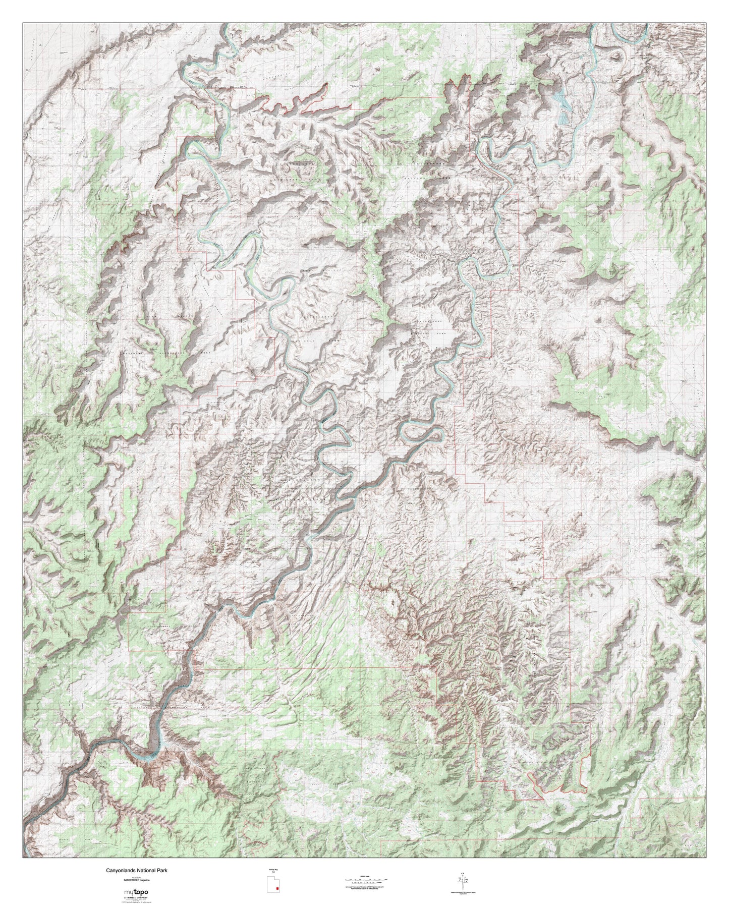
This topographic map with enhanced relief shading is printed on 4'x5' rolled indoor/outdoor banner paper. At 1:50,000 scale, you can fill your wall with the entire park--from Island in the Sky and the Green River in the north of the park, The Maze in the central region of the park, and The Needles District along the Colorado River in the southern fringes of the park.
Contains the following named locations: 84532,84535,Airport Tower,Amasa Back,Anderson Bottom,Anticline Campground,Anticline Overlook,Aztec Butte,Bagpipe Butte,Bagpipe Butte Overlook,Beaver Bottom,Beef Basin,Beef Basin Wash,Beehive Butte,Best Inscription-1891,Big Drop Rapids,Big Flat Reservoir,Big Pocket,Big Pond,Big Spring Canyon Overlook,Bighorn Mesa,Black Ledge,Bobbys Hole,Bogus Pocket,Bonita Bend,Boundary Butte,Bowdie Point,Bridger Jack,Bridger Jack Mesa,Bridger Jack Mesa Outstanding Natural Area,Bright Angel Trail,Brimhall Point,Brown Betty Rapids,Buck Canyon Overlook,Buck Mesa,Butler Wash,Buttes of the Cross,Calamity Mesa,Candlestick Tower,Canyonlands National Park,Canyonlands Overlook,Canyonlands Resort,Cathedral Butte,Cathedral Point,Cave Spring Trail,Cedar Mesa,Chimney Rock,Chocolate Drops,Cleopatras Chair,Colorado River Overlook,Confluence Overlook,Corral Pocket,Cyclone Canyon,D Julien Inscription-1836,Dark Canyon Plateau,Dark Canyon Primitive Area,Dead Horse Point,Dead Horse Point Campground,Dead Horse Point Overlook,Dead Horse Point State Park,Dead Horse Point State Park Visitor Center,Devils Lane,Devils Pocket,Dugout Dam,Dugout Ranch,Dugout Reservoir,East Fork Salt Creek,Eddy Inscription-1927,Eightmile Rock,Ekker Butte,Elaterite Basin,Elaterite Butte,Elephant Hill,Ernies Country,Flint Trail,Flint Trail Overlook,Fort Bottom,Frank Shafer Number 1 Oil Well,Goose Neck,Grand View Point Overlook,Great Gallery Pictographs,Green River,Green River Overlook,Gunsight Butte,Hans Flats Ranger Station,Hardscrabble Bottom,Harts Point,Hatch Point,Hatch Point Campground,Head Spur,High Spur,Holeman Spring Basin,Hop Creek,Horsehead Rock,Horseshoe Canyon Unit- Canyonlands National Park,Horsethief Bottom,Horsethief Point,Horsethief Trail,House Park Butte,Indian Creek,Island in the Sky,J H Shafer Number 1 Oilwell,J L Eddy,Jackson Bottom,Jackson Hole,Joint Trail,Junction Butte,Kane Springs Creek,Keg Knoll,Kings Bottom,Kirby Pond,Kirk Cabin,Kirk Fence,Kolb Inscription-1911,Land of Standing Rocks,Lands End,Lavender Creek,Lizard Rock,Lockhart Basin,Low Spur,Lower Jump,Maze Overlook,Middle Point,Mile Long Rapids,Millard Canyon Benches,Millard Canyon Overlook,Mineral Bottom,Monument Basin,Mormon Pasture Point,Muffin Butte,Murphy Hogback,Murphy Point Overlook,Murphy Range,Neck Ranger Station,Needles Outpost Campground,Nevills Inscription,North Block,North Cottonwood Creek,North Cottonwood Guard Station,North Point,North Sixshooter Peak,North Trail,Observation Rock,Ocean Point,Panorama Point Overlook,Pappys Pasture,Petes Mesa,Point Bottom,Potash,Potato Bottom,Potato Bottom Basin,Pothole Point,Pyramid Butte,Queen Ann Bottom,Red Cove,Red Point,Red Sea,Rim View,S.O.B. Hill,Saddle Horse Bottom,Salt Creek,Salt Creek Mesa,Salt Creek Pocket,Shafer Basin,Shafer Trail,Shay Mesa,Shay Mountain,Sheep Bottom,Silver Stairs,Sin-av-to-weap,Soda Springs Basin,South Sixshooter Peak,Spanish Bottom,Squaw Butte,Squaw Flat Campground,Standing Rock,Steer Mesa,Sugarloaf Butte,Teapot Rock,TexasGulf Potash Pond One A,TexasGulf Potash Pond One A Dam,TexasGulf Potash Pond Three A,TexasGulf Potash Pond Three A Dam,TexasGulf Potash Pond Three B,TexasGulf Potash Pond Three B Dam,TexasGulf Potash Pond Two G,TexasGulf Potash Pond Two G Dam,TexasGulf Potash Pond Two N,TexasGulf Potash Pond Two N Dam,The Big Ridge,The Block,The Button,The Confluence,The Doll House,The Fins,The Golden Stairs,The Grabens,The Hat,The Island,The Knoll,The Loop,The Mailbox,The Maze,The Mother and Child,The Needles,The Needles Country,The Needles Overlook,The Needles Ranger Station,The Plug,The Sphinx,The Totem Pole,The Wall,Thirteen Faces,Tidwell Bottom,Tidwell Ranch,Turks Head,Tuxedo Bottom,Twin Valleys,United Nations Tablet,Unknown Bottom,Upheaval Bottom,Upheaval Dome,Upheaval Dome Trail,Upper Jump,Valentine Bottom,West Fork Lavender Creek,West Fork Salt Creek,Whale Rock,Whitbeck Rock,White Rim Trail,Williams Bottom,Willow Flat Campground,Wilson Ranch,Woodruff Bottom,Zeus and Moses