MyTopo
Williamsport Maryland US Topo Map
Couldn't load pickup availability
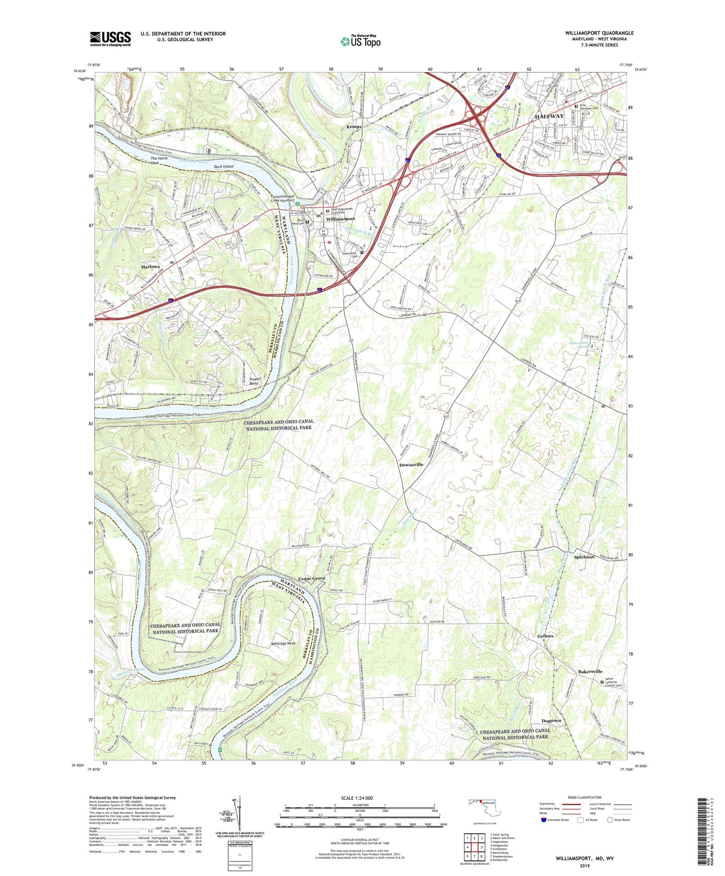
2019 topographic map quadrangle Williamsport in the states of Maryland, West Virginia. Scale: 1:24000. Based on the newly updated USGS 7.5' US Topo map series, this map is in the following counties: Washington, Berkeley. The map contains contour data, water features, and other items you are used to seeing on USGS maps, but also has updated roads and other features. This is the next generation of topographic maps. Printed on high-quality waterproof paper with UV fade-resistant inks.
Quads adjacent to this one:
West: Hedgesville
Northwest: Clear Spring
North: Mason and Dixon
Northeast: Hagerstown
East: Funkstown
Southeast: Keedysville
South: Shepherdstown
Southwest: Martinsburg
Contains the following named places: Bakersville, Bakersville Census Designated Place, B'nai Abraham Cemetery, Byron Park, Calvary Temple, Cedar Grove, Cedar Grove Mill, Cedar Grove School, Center Hill School, Charles Mill, Chesapeake and Ohio Canal, Church of the Holy Trinity, Cloverton, Conococheague Creek, Conococheague Creek Aqueduct, Conococheaque, County Medical Transport, Crazy Neck, Cross Mill, Danner's Greenhouse, Dellinger School, Dellinger Wide Water, District 2 Williamsport, District 20 Downsville, District 26 Halfway, Dogtown, Downey Branch, Downsville, Downsville Census Designated Place, Downsville Christian Church, Downsville Church of the Brethren, Duck Island, Ebenezer Christian School, Fair Play Mill, Fairplay Farms, Falling Waters Post Office, Fountain Rock Elementary School, Fountain Rock Farm, Friendship Park, Gateway Christian Academy, Gay Street Brethren Church, Greenlawn Cemetery, Grimes, Guard Lock Number 5, Halfway, Halfway Census Designated Place, Halfway County Park, Halfway Manor, Halfway Public School, Heritage Estates, Hickory Elementary School, Homewood Retirement Center, Interstate Industrial Park, Jordan Run, Kemps, Lake Fairplay Estates, Lanes School, Legacy Manor, Lemons Ferry, Lights Ferry, Lincolnshire Elementary School, Lock 45, Magruder Run, Maidstone School, Marlowe, Marlowe Elementary School, Marsh Run, Marty Snook County Park, Mount Moriah, Mount Moriah Church, Mount Olive Church, Oak Ridge, Old Orchard Shopping Center, Opequon Creek, Opequon Farms, Opequon Junction Campground, Pinesburg Quarry, Pinesburg Station, Pleasant View Estates, Potomac Park, Potomac Park Camp and Retreat Center, Potomac River Reservoir, Potomac Siding, Potomac Woodlands, Powell Bend, Rehoboth United Methodist Church, River View Cemetery, Safari Campground, Saint Andrew Church, Saint Augustine Catholic Church, Saint Augustines Graveyard, Saint James, Saint James Brethren Church, Saint James Chapel, Saint James High School, Saint James Post Office, Saint James Run, Saint James School, Saint James Spring, Saint Joseph Catholic Church, Salem Church, Salem Lutheran Church Cemetery, Semple Run, Spielman, Spring Dell Farm, Spring Grove School, Springfield Middle School, Springfield Run, Tammany Manor, The Horse Shoe, Town of Williamsport, Valley Grace Brethren Church, Van Lear Brethren Church, Van Lear Manor, Virginia Avenue Baptist Church, Volunteer Fire Company of Halfway Company 26, Washington County, Washington County Sheriff's Office, Washington Four, Whitings Neck, Williamsport, Williamsport Church, Williamsport Church of God, Williamsport City Hall, Williamsport Elementary School, Williamsport High School, Williamsport Memorial Library, Williamsport Post Office, Williamsport Power Plant Dam, Williamsport Sanitarium, Williamsport Station, Williamsport United Methodist Church, Williamsport Volunteer Fire Department and Emergency Medical Services Company 2, Woburn Estates, Woburn School, Woodburn on the Potomac, Woodmoor, WYII-FM (Williamsport), Ziem Winery, Zion Lutheran Church, ZIP Codes: 21733, 21781, 21795