MyTopo
Flushing Michigan US Topo Map
Couldn't load pickup availability
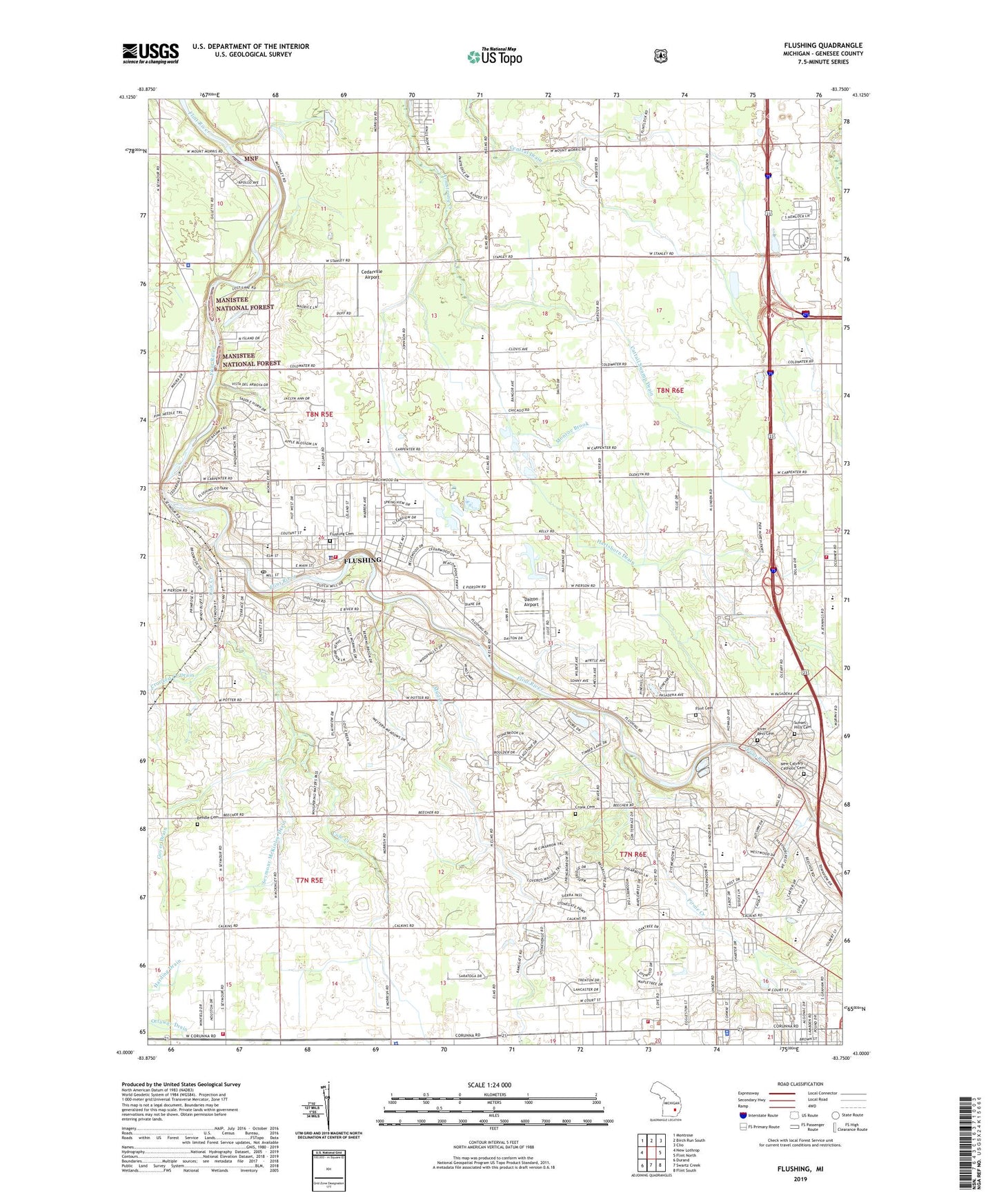
2019 topographic map quadrangle Flushing in the state of Michigan. Scale: 1:24000. Based on the newly updated USGS 7.5' US Topo map series, this map is in the following counties: Genesee. The map contains contour data, water features, and other items you are used to seeing on USGS maps, but also has updated roads and other features. This is the next generation of topographic maps. Printed on high-quality waterproof paper with UV fade-resistant inks.
Quads adjacent to this one:
West: New Lothrop
Northwest: Montrose
North: Birch Run South
Northeast: Clio
East: Flint North
Southeast: Flint South
South: Swartz Creek
Southwest: Durand
Contains the following named places: Amos Woodruff Historical Marker, Amos Woodruff House Historical Marker, Baillies Pond, Bendle Cemetery, Bethel General Baptist Church, Birchwood Mobile Home Park, Bowman Drain, Brown School, Caldwell School, Calvary Church, Calvary Temple Full Gospel Church, Carman High School, Carpenter Road Apostolic Church, Cattail Swamp Drain, Cedarville Airport, Central School, Charter Township of Clayton, Charter Township of Flint, Charter Township of Flushing, Church of the Nazarene, City of Flushing, Clayton Township Police Department, Cole Creek, Colonial Hills Baptist Church, Community of Hope Church of God, Cornerstone Community Church, Cottrell Drain, Cronk Cemetery, Dalton Airport, Dye Junior High School, Dye School, Eastview Park, Elms School, First Baptist Church Flushing, First Christian Church, First Methodist Episcopal Church Historical Marker, Five Fold Ministry Christian Church, Flint City Cemetery, Flint Sewage Disposal, Flint Township Fire Department Station 1, Flushing, Flushing Area Museum, Flushing Cemetery, Flushing City Hall, Flushing Community Church, Flushing Estates Mobile Home Park, Flushing Fire Department, Flushing High School, Flushing Junior High School, Flushing Library, Flushing Medical Center, Flushing Park, Flushing Pointe Church of Christ, Flushing Police Department, Flushing Post Office, Flushing Presbyterian Church, Flushing Station, Flushing Township Police Department, Flushing United Methodist Church, Flushing Valley Country Club, Genesee Intermediate School, Good Shepherd Lutheran Church, Goyer Drain, Graham School, Gustin School, Harrison Homestead Historical Marker, Hartshorn Drain, Heather Hill Estates Mobile Home Park, Holy Cross Lutheran Church, Judah Full Gospel Baptist Church, King of Glory Lutheran Church, Kingdom Hall of Jehovah's Witnesses, Mayfair Bible Church, McLaren Community Medical Center, Meadowbrook Manor Estates Mobile Home Park, Messmore Cronk Drain, Michigan State Police District 3 Flint Post 35, Michigan State Police District 3 Headquarters, Monroe Brook, Mount Morris Township Fire Station 2, Mud Creek, Mutton Park, New Calvary Catholic Cemetery, New Covenant Christian Church, New Hope Baptist Church, New Life Assembly of God Church, Payson School, Pheasant Run Mobile Home Park, Pirnie Creek, Pollock Brook, River Rest Cemetery, River Road Park, Root Drain, Saint Michael Byzantine Catholic Church, Saint Robert Catholic Church, Saint Roberts School, Seymour McKinley Drain, Seymour School, Springview School, Stadler Drain, Sunset Hills Cemetery, Swartz Creek Area Fire Department Station 2, Township of Mount Morris, Trinity Baptist Church, Trinity Episcopal Church, Utley Junior High School, Warner School, Westside Baptist Church, Westwood Church of God, Westwood Heights Mobile Home Park, Westwood Heights School, White Oak Estates Mobile Home Park, White Oaks Estates Mobile Home Park, Winchester Hospital, ZIP Codes: 48433, 48532