MyTopo
Jefferson City Missouri US Topo Map
Couldn't load pickup availability
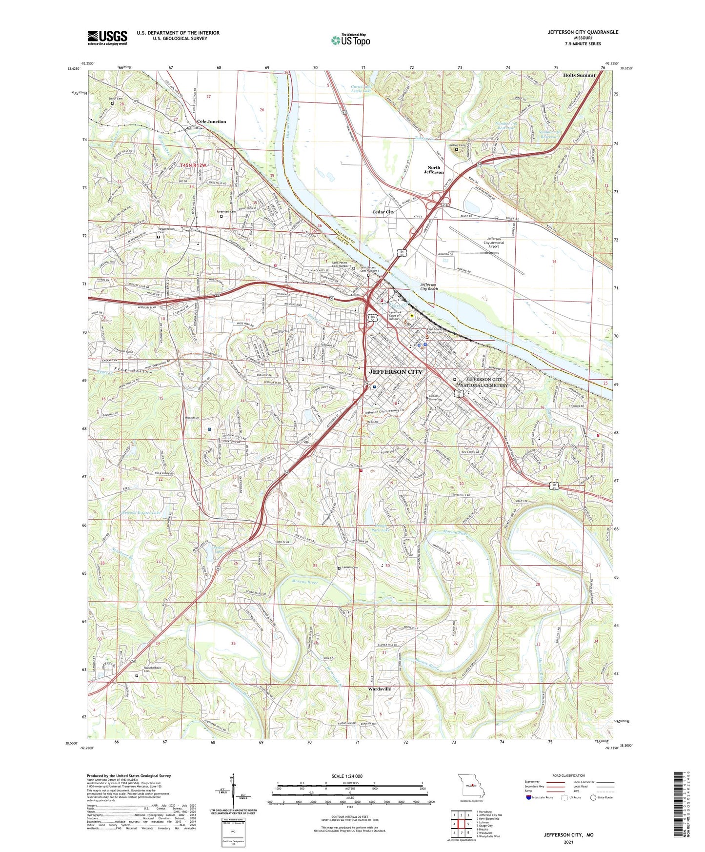
2021 topographic map quadrangle Jefferson City in the state of Missouri. Scale: 1:24000. Based on the newly updated USGS 7.5' US Topo map series, this map is in the following counties: Cole, Callaway. The map contains contour data, water features, and other items you are used to seeing on USGS maps, but also has updated roads and other features. This is the next generation of topographic maps. Printed on high-quality waterproof paper with UV fade-resistant inks.
Quads adjacent to this one:
West: Lohman
Northwest: Hartsburg
North: Jefferson City NW
Northeast: New Bloomfield
East: Osage City
Southeast: Westphalia West
South: Wardsville
Southwest: Brazito
Contains the following named places: Alton Creek, Balcer Aero South Airport, Belair Elementary School, Boggs Creek, Bougher, Capital Region Medical Center, Capital View Station Post Office, Carmelite Monastery, Cedar City, Cedar Hill Elementary, Charles E Still Hospital Heliport, City of Jefferson City, Cole County Sheriff's Office, Cole Junction, Dix Road Shopping Center, East Elementary School, East Union School, Ellis-Porter Park, Fairview Cemetery, Faith Lutheran Church, Frog Hollow, Gerbes Center, Grand View School, Grays Creek, Gurwit and Lewis Lake, Gurwit and Lewis Lake Dam, Halifax School, Harthill Cemetery, Helias High School, Herbrandt Branch, Hough Park, Hough Park Dam, Hough Park Lake, Immaculate Conception Catholic Church, Immaculate Conception School, Jefferson City, Jefferson City Fire Department Hype Park Training Center, Jefferson City Fire Department Station 1, Jefferson City Fire Department Station 2, Jefferson City Fire Department Station 3, Jefferson City Fire Department Station 4, Jefferson City High School, Jefferson City Memorial Airport, Jefferson City National Cemetery, Jefferson City Police Department, Jefferson City Post Office, Jefferson City Reach, Jefferson Landing State Historic Site, Jefferson Plaza, KJMO-FM (Jefferson City), KLIK-AM (Jefferson City), KWOS-AM (Jefferson City), Lakewood Dam, Lakewood Estates Lake, Lamkin Cemetery, LaSalette Seminary, Lavinia Park, Lewis and Clark Middle School, Lincoln University, Lincoln University Farm, Mart Shopping Center, McClung Park, Memorial Community Hospital, Missouri State Capitol, Missouri State Highway Patrol Headquarters, Moreau Bend School, Moreau Heights Elementary School, Neighorn Branch, Nichols Career Center, North Jefferson, Number 136 Reservoir, Number 139 Reservoir, Prenger Family Center, Renns Lake, Renns Lake Dam, Renz Correction Center, Resurrection Cemetery, Riverview Cemetery, Rouschelback Cemetery, Runge Conservation Nature Center, Saint Marys Health Center Heliport, Saint Peter Church, Saint Peter Interparish School, Saint Peters Cemetery Number 1, Saint Peters Cemetery Number 2, Schumate Chapel, Shadow Lake Dam, Shoppers Mart, Simonsen Ninth Grade Center, Smith Cemetery, South Elementary School, Southridge Shopping Center, Southwest Early Childhood Center, Southwest Plaza, SSM Health Saint Mary's Hospital - Jefferson City, Still Hospital, Sunset Lake, Sunset Lake Dam, Thorpe J. Gordon Elementary School, Township of Jefferson, Township of Summit, Trimble Lake East Dam, Trimble Lake West Dam, Trinity Lutheran School, Turkey Creek, Washington Park, Wears Creek, West Elementary School, West Village Plaza, Woodland - Old City Cemetery, Zion School