MyTopo
Bennet Nebraska US Topo Map
Couldn't load pickup availability
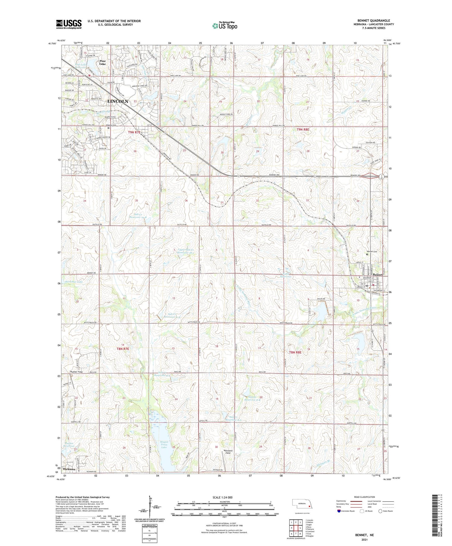
2021 topographic map quadrangle Bennet in the state of Nebraska. Scale: 1:24000. Based on the newly updated USGS 7.5' US Topo map series, this map is in the following counties: Lancaster. The map contains contour data, water features, and other items you are used to seeing on USGS maps, but also has updated roads and other features. This is the next generation of topographic maps. Printed on high-quality waterproof paper with UV fade-resistant inks.
Quads adjacent to this one:
West: Roca
Northwest: Lincoln
North: Walton
Northeast: Eagle
East: Palmyra
Southeast: Douglas
South: Firth
Southwest: Cortland
Contains the following named places: Bennet, Bennet Community Church, Bennet Fire and Rescue, Bennet Post Office, Cheney, Cheney Cemetery, Cheney Census Designated Place, Cheney Post Office, Cheney Public School, Edenton South Park, Farmers Co-op Elevator, Grant Election Precinct, Harlan Reservoir, Hidden Valley Golf Course, Jensen Park, KEZG-FM (Lincoln), Kuhn Dam, Kuhn Reservoir, Mueller Field, Nebraska Heart Hospital, Nemaha Election Precinct, Pine Lake, Pine Lake Dam, Pine Lake Golf Course, Pine Lake Reservoir, Saint Michael Catholic Church, Salt Creek 9-3 Dam, Salt Creek Dam 19-B, Salt Creek Dam 8-A, Salt Creek Dam 8-B, Salt Creek Dam 9-A, Salt Creek Reservoir 19-B, Salt Creek Reservoir 8-A, Salt Creek Reservoir 8-B, Salt Creek Reservoir 9-3, Salt Creek Reservoir 9-A, Southeast Rural Fire District - Pine Lake Station, Stewart Field Airport, Stockton Election Precinct, Township of Grant, Township of Nemaha, Township of Saltillo, Township of Stockton, Upper Salt Creek Dam 36-1, Upper Salt Creek Reservoir 36-1, Village of Bennet, Wagon Train Lake, Wagon Train Lake State Recreation Area, Walvoord Field, ZIP Codes: 68317, 68526