MyTopo
Roselle New Jersey US Topo Map
Couldn't load pickup availability
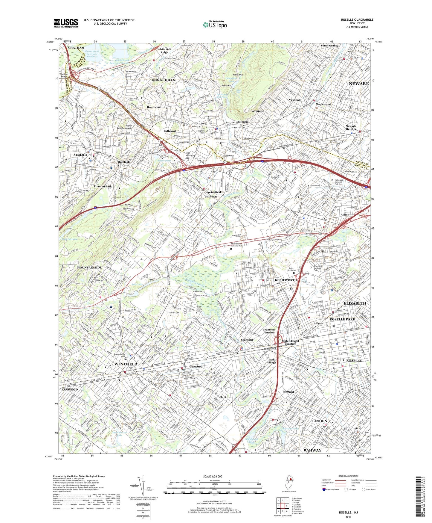
2019 topographic map quadrangle Roselle in the state of New Jersey. Scale: 1:24000. Based on the newly updated USGS 7.5' US Topo map series, this map is in the following counties: Union, Essex, Morris. The map contains contour data, water features, and other items you are used to seeing on USGS maps, but also has updated roads and other features. This is the next generation of topographic maps. Printed on high-quality waterproof paper with UV fade-resistant inks.
Quads adjacent to this one:
West: Chatham
Northwest: Morristown
North: Caldwell
Northeast: Orange
East: Elizabeth
Southeast: Arthur Kill
South: Perth Amboy
Southwest: Plainfield
Contains the following named places: Abraham Clark High School, Aldene, Baltusrol, Baltusrol Golf Course, Baltusrol Station, Beech Brook, Beth - David Cemetery, Beth Shalom School, Biertuempful Park, Blackbrook Park, Bloodgoods Pond, Bloodgoods Pond Dam, B'Nai Abraham Memorial Park, Borough of Garwood, Borough of Kenilworth, Borough of Mountainside, Borough of Roselle, Borough of Roselle Park, Brantwood, Brayton Elementary School, Briant Park, Briant Park Dam, Briant Pond, Brightwood Park, Brookside Park, Brookside Place Elementary School, Campbells Pond, Campbells Pond Dam, Canoe Brook Reservoir Number 2, Canoe Brook Reservoir Number One, Central Five-Jefferson Elementary School, Charles H Brewer School, Chatham Bridge, Children's Specialized Hospital, Chisholm School, City of Summit, Clark, Clark Memorial Park, Cleveland School, Columbia High School, Columbus School, Connecticut Farms, Connecticut Farms Census Designated Place, Connecticut Farms Elementary School, Cranford, Cranford Census Designated Place, Cranford Hall Nursing Home, Cranford High School, Cranford Junction, Cranford Station, Deerfield Elementary School, Diamond Mill Pond, Doctor Charles C Polk School, East Branch Rahway River, East Orange Golf Course, Echo Lake, Echo Lake Golf Course, Echo Lake Park, Echo Plaza Shopping Center, Edison Recreation Center, Elizabeth River Parkway, Elm Street School, Ernest J Finizio-Aldene Elementary School, Fairview Cemetery, Far Brook School, Fielding School, Florence M Gaudineer Middle School, Fox Hill Reserve, Franklin Elementary School, Friberger Park, Galloping Hill Park and Golf Course, Garwood, Glenwood Elementary School, Graceland Memorial Park, Grant School, Grove Park, Hamilton School, Harding Elementary School, Hawk Hill, Henshaw Playground, Hidden Valley Park, Hollywood Cemetery, Hollywood Memorial Park Cemetery, Holy Trinity High School, Huntley Station, Irwin Playground, Jacksons Pond, Jacksons Pond Dam, Jefferson Elementary School, Jonathan Dayton High School, Kawameeh Middle School, Kawameeh Park, Kenilworth, Kent Place School, Lawton C Johnson Summit Middle School, Lenape Park, Lincoln Franklin Elementary School, Lincoln School, Linden Station, Livingston Elementary School, Maple Brook, Maple Falls, Maplecrest Park, Maplewood, Maplewood Census Designated Place, Maplewood Golf Course, Maplewood Station, McKinley Elementary School, McKinley School, Meadowland Park, Memorial Field, Memorial Park, Metro Homes Field, Millburn, Millburn Census Designated Place, Millburn Station, Milltown, Mindowaskin Park, Mountainside, Mountainside School, Myles J McManus Elementary School, Newark Heights, Nomahegan Brook, Nomahegan Park, Nook Hill, Number 1 Elementary School, Number 5 Elementary School, Number 8 Elementary School, Oak Knoll School, Olympic Park, Overlook, Overlook Hospital Union Campus, Overlook Medical Center, Park Village, Rahway River Parkway, Ravens Nest Heliport, Revolutionary Cemetery, Roosevelt Intermediate School, Roosevelt School, Roselle, Roselle Golf Course, Roselle Park, Roselle Park Station, Saint Annes School, Saint Christophers School, Saint Elizabeths School, Saint James School, Saint Johns School, Saint Josephs School, Saint Michael School, Saint Michaels School, Saint Rose of Lima School, Saint Stephens Cemetery, Saint Theresa Elementary School, Scotch Plains Census Designated Place, Scotch Plains Public School Number 3, Second Ward Park, Seth Boyden Elementary School, Shackamaxon Dam, Shackamaxon Golf Course, Shackamaxon Lake, Shackamaxon School, Sherman Elementary School, Sherman School, Short Hills, Short Hills Census Designated Place, Short Hills Mall Shopping Center, Short Hills School, Short Hills Station, Slayton Field, Soldiers Memorial Field, South Mountain Elementary School, South Mountain Reservation, South Orange, South Orange Census Designated Place, South Orange Station, Springfield, Springfield Census Designated Place, Springfield Station, Staten Island Junction, Suburban Golf Course, Summit, Summit Oaks Hospital, Summit Station, Tamaques Reservation, Tatlock Sports Complex, Taylor Park, Town of Westfield, Township of Cranford, Township of Maplewood, Township of Millburn, Township of Scotch Plains, Township of South Orange Village, Township of Springfield, Township of Union, Township of Winfield, Tremont Park, Tuscan Elementary School, Unami Park, Underhill Field, Union, Union Census Designated Place, Union County, Union Junior College, Unionburg, Vauxhall, Vauxhall Census Designated Place, Ward Homestead, Washington Elementary School, Washington Rock Outlook, Watchung Reservation, Westfield, Westfield Station, White Oak Ridge, White Oak Ridge Park, Wilson Park, Winfield, WJDM-AM (Elizabeth), Wyoming, ZIP Codes: 07016, 07027, 07033, 07040, 07041, 07076, 07078, 07079, 07081, 07083, 07088, 07090, 07092, 07203, 07204, 07901