
MyTopo
Baldwinsville New York US Topo Map
Couldn't load pickup availability
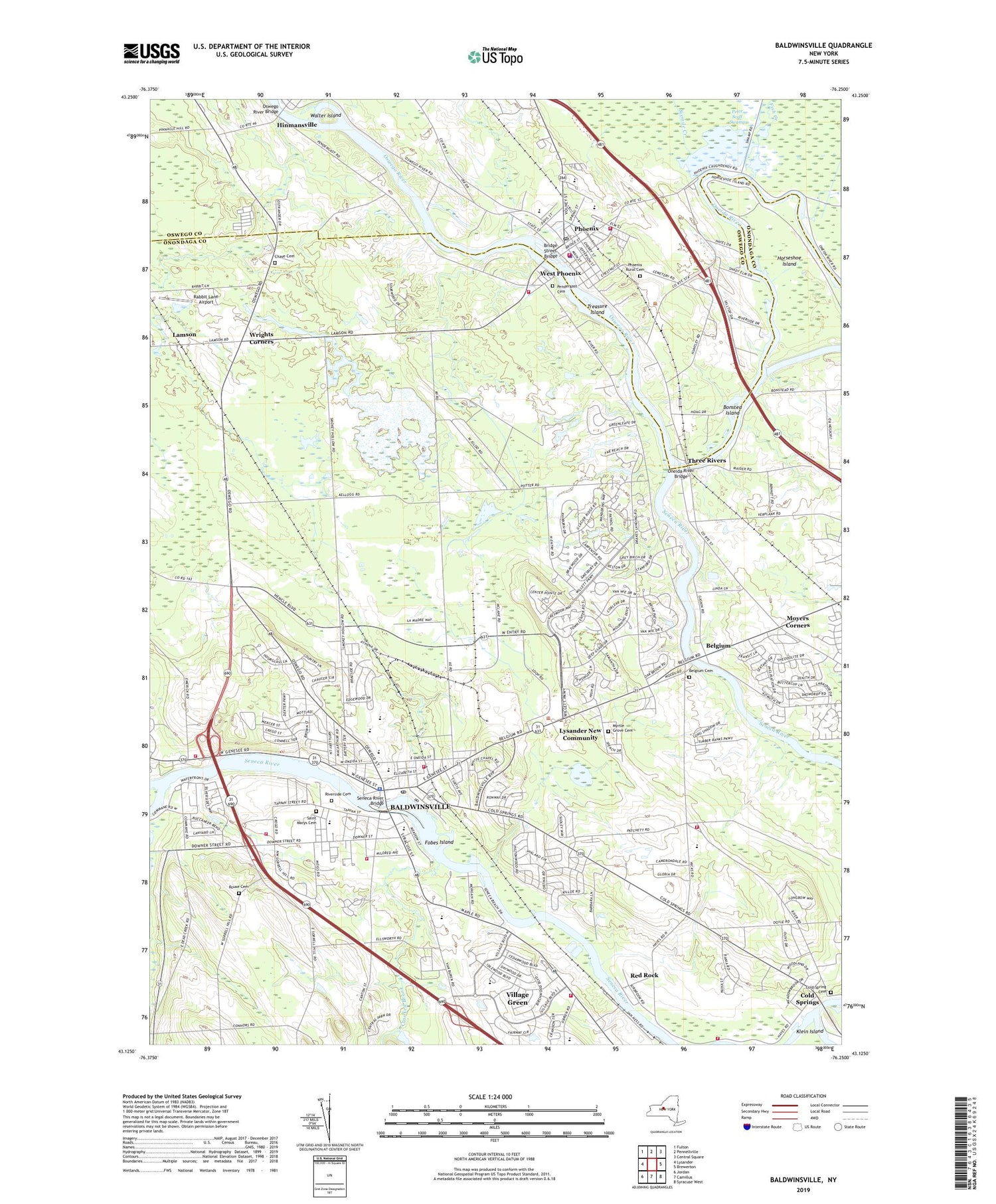
2019 topographic map quadrangle Baldwinsville in the state of New York. Scale: 1:24000. Based on the newly updated USGS 7.5' US Topo map series, this map is in the following counties: Onondaga, Oswego. The map contains contour data, water features, and other items you are used to seeing on USGS maps, but also has updated roads and other features. This is the next generation of topographic maps. Printed on high-quality waterproof paper with UV fade-resistant inks.
Quads adjacent to this one:
West: Lysander
Northwest: Fulton
North: Pennellville
Northeast: Central Square
East: Brewerton
Southeast: Syracuse West
South: Camillus
Southwest: Jordan
Contains the following named places: Abbott Farms, Baldwinsville, Baldwinsville Fire Department Station 1, Baldwinsville Fire Department Station 2, Baldwinsville Fire Department Station 3, Baldwinsville Post Office, Baldwinsville Public Library, Baldwinsville Sanitarium, Baldwinsville Village Fire Department, Baldwinsville Village Hall, Beacon Gospel Tabernacle, Belgium, Belgium Cemetery, Belgium Cold Springs Fire Department, Big Ben Cut, Bonsted Island, Bridge Street Bridge, B-Ville Airpark, Catherine M McNamara Elementary School, Charles W Baker High School, Chase Cemetery, Cherry School, Childtime Children's Center, Christian Reformed Church, Cold Spring Cemetery, Cold Springs, Cold Springs Church, Community Wesleyan Church, Crooked Brook, Dillon School, Donald S Ray School, Elizabeth Street School, Elm Street School, Enterprise Fire Company 1 Station 1, Enterprise Fire Company 1 Station 2, Enterprise Fire Company 1 Station 3, First Baptist Church, First Congregational United Church of Christ, First Presbyterian Church, First United Methodist Church, Fish Creek, Fobes Island, Grace Church, Greater Baldwinsville Ambulance Corps, Harry E Elden Elementary School, Hinmansville, Horseshoe Island, Indian Hills Mobile Home Park, Ironwood Country Club, John C Birdlebough High School, Kingdom Hall Church, L Pearl Palmer Elementary School, Lamson, Lamson Road Community Church, Lock Number 1, Lock Number 24, Lysander New Community, Lysander Town Hall, Mae E Reynolds School, Moyers Corners, Myrtle Grove Cemetery, North Side Sewage Disposal Plant, Oneida River, Oneida River Bridge, Oswego River Bridge, Palace Variety Theatre, Pendergast Cemetery, Peter Scott Swamp, Phoenix, Phoenix Post Office, Phoenix Public Library, Phoenix Rural Cemetery, Phoenix Sewage Treatment Plant, Plainville Fire Department, Rabbit Lane Airport, Radisson, Radisson Census Designated Place, Radisson Corporate Park, Red Rock, Riverside Cemetery, Rouse Cemetery, Saint Augustines Church, Saint Mark's Lutheran Church, Saint Marys Cemetery, Saint Mary's Roman Catholic Church, Saint Marys School, Saint Stephen's Church, School Number 1, School Number 10, School Number 11, School Number 12, School Number 14, School Number 16, School Number 2, School Number 3, School Number 6, School Number 7, Seneca River, Seneca River Bridge, Seneca River Fire Department, Silver Rock Mobile Home Park, Sixmile Creek, South Side Graded School, South Side Sewage Disposal Plant, Theodore R Durgee Junior High School, Three Rivers, Three Rivers State Wildlife Management Area, Town of Lysander, Treasure Island, Van Buren Elementary School, Village Green, Village Green Census Designated Place, Village of Baldwinsville, Village of Phoenix, Walter Island, WBXL-FM (Baldwinsville), West Phoenix, Word of Life Christian Academy, Wrights Corners, WSEN-AM (Baldwinsville), WSEN-FM (Baldwinsville), ZIP Code: 13027


