MyTopo
Maybrook New York US Topo Map
Couldn't load pickup availability
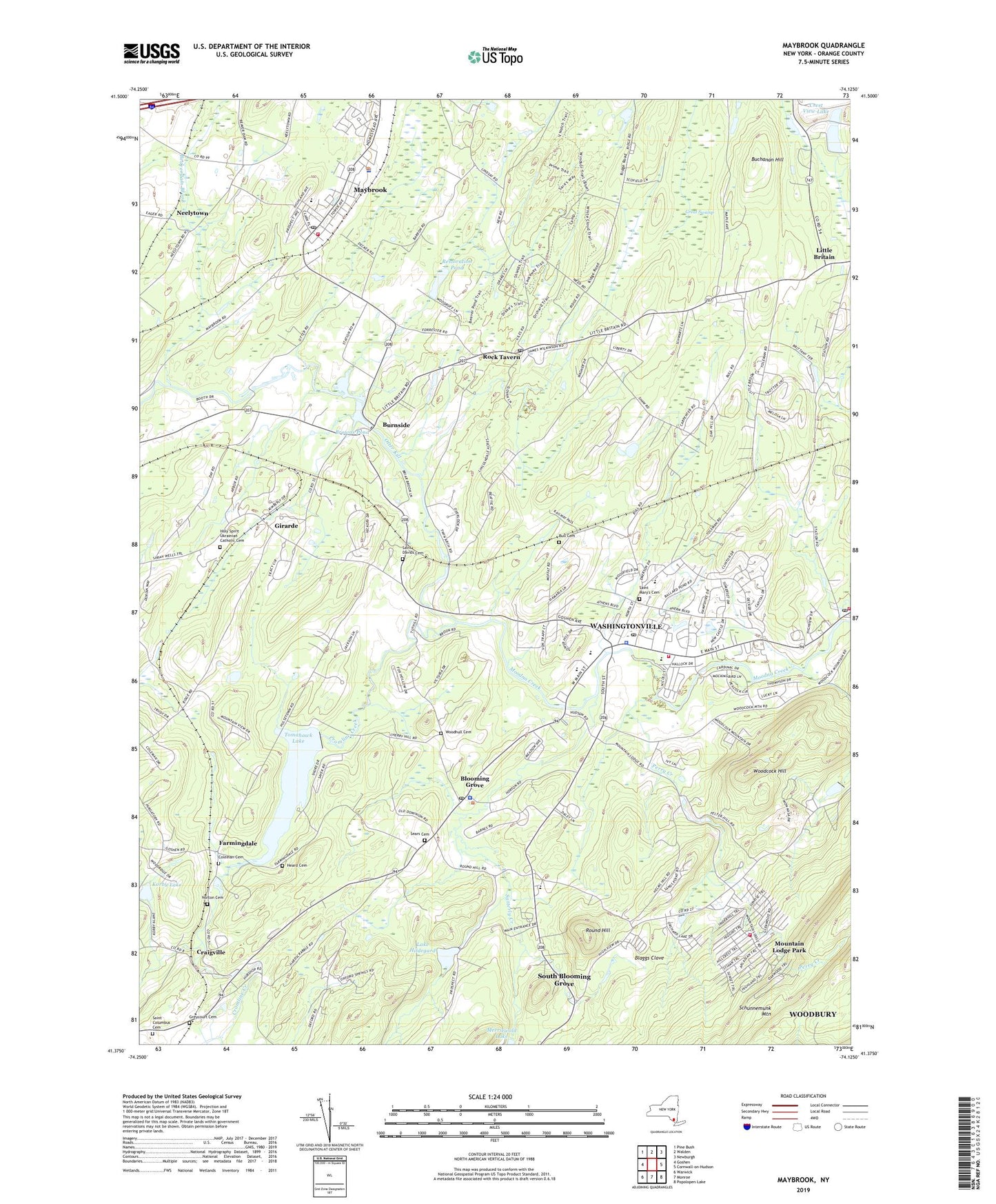
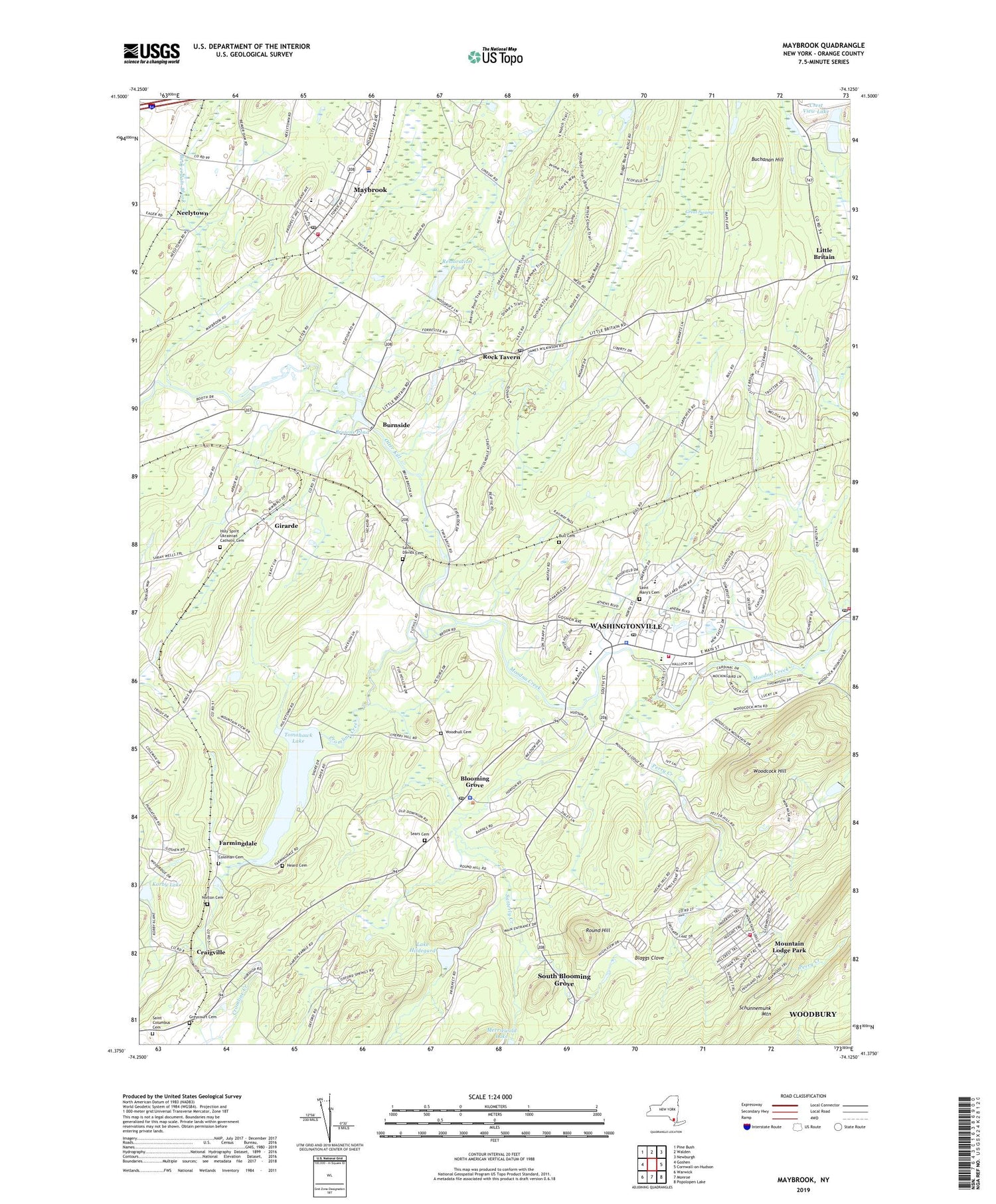
2019 topographic map quadrangle Maybrook in the state of New York. Scale: 1:24000. Based on the newly updated USGS 7.5' US Topo map series, this map is in the following counties: Orange. The map contains contour data, water features, and other items you are used to seeing on USGS maps, but also has updated roads and other features. This is the next generation of topographic maps. Printed on high-quality waterproof paper with UV fade-resistant inks.
Quads adjacent to this one:
West: Goshen
Northwest: Pine Bush
North: Walden
Northeast: Newburgh
East: Cornwall-on-Hudson
Southeast: Popolopen Lake
South: Monroe
Southwest: Warwick
Contains the following named places: Arbor Valley, Beaverdam Brook, Bethany Presbyterian Church, Blaggs Clove, Blooming Grove, Blooming Grove Plaza Shopping Center, Blooming Grove Post Office, Blooming Grove Town Hall, Blooming Grove United Church of Christ, Blooming Grove Volunteer Ambulance Corps, Brookview Acres Mobile Home Park, Brotherhood Plaza Shopping Center, Browns Pond, Buchanan Hill, Bull Cemetery, Bulls Siding, Burnside, Burnside Station, Camp Lenni-Len-A-Pe, Canterbury Estates, Clove Acres Riding Academy, Coleman Cemetery, Craigville, Craigville Bible Church, Crest View Lake, Cromline Creek, El Shaddai Christian Church, Farmingdale, First Presbyterian Church, Girarde, Grace Community Baptist Church, Great Swamp, Greycourt Cemetery, Hampton Trails, Heard Cemetery, Holy Spirit Ukrainian Catholic Cemetery, Hudson School, Hudson Valley Circle of Learning School, Huston School, Kimberly Estates, Korby Lake, L Vern Allen Park, Lake Anne Golf Course, Lake Hildegard, Lincolndale School, Little Britain, Little Britain Post Office, Little Britian Station, Maybrook, Maybrook Drive-In, Maybrook Engine Company 1, Maybrook Methodist Church, Maybrook Post Office, Maybrook Village Hall, Mays Field, Mitigation Pond, Moffat Library, Mountain Lodge Park, Mountain Lodge Park Census Designated Place, Neelytown, Norton Cemetery, Otter Kill, Otter Kill Estates, Otter Kill Golf and Country Club, Peoples Regular Baptist Church, Perry Creek, Restoration Pond, Rock Tavern, Rock Tavern Post Office, Roe's Orchards, Round Hill, Round Hill Elementary School, Rural Ridge, Saint Andrew Ukranian Church, Saint Anne's Episcopal Church, Saint Columbus Cemetery, Saint Davids Cemetery, Saint Mary's Catholic Church, Saint Mary's Cemetery, Salisbury Mills Fire Department Mountain Lodge Park Fire Company, Salisbury Mills Post Office, Salisbury Mills Volunteer Fire Department Salisbury Mills Fire Company, Satterly Creek, School Number 12, School Number 7, Sears Cemetery, Seely Brook, Station Road Square Shopping Center, Taft Elementary School, Tappan Hill, Tomahawk Lake, Toro Hill Pond, Town of Blooming Grove, Unitarian Universalist Congregation at Rock Tavern, Village of Maybrook, Village of Washingtonville, Washingtonville, Washingtonville Fire Department Monell Engine Company, Washingtonville Middle School, Washingtonville Post Office, Washingtonville Senior High School, Washingtonville Village Hall, WGNY-FM (Newburgh), Woodcock Hill, Woodfield, Woodhull Cemetery, ZIP Codes: 10914, 10992, 12543, 12575