MyTopo
Canton East Ohio US Topo Map
Couldn't load pickup availability
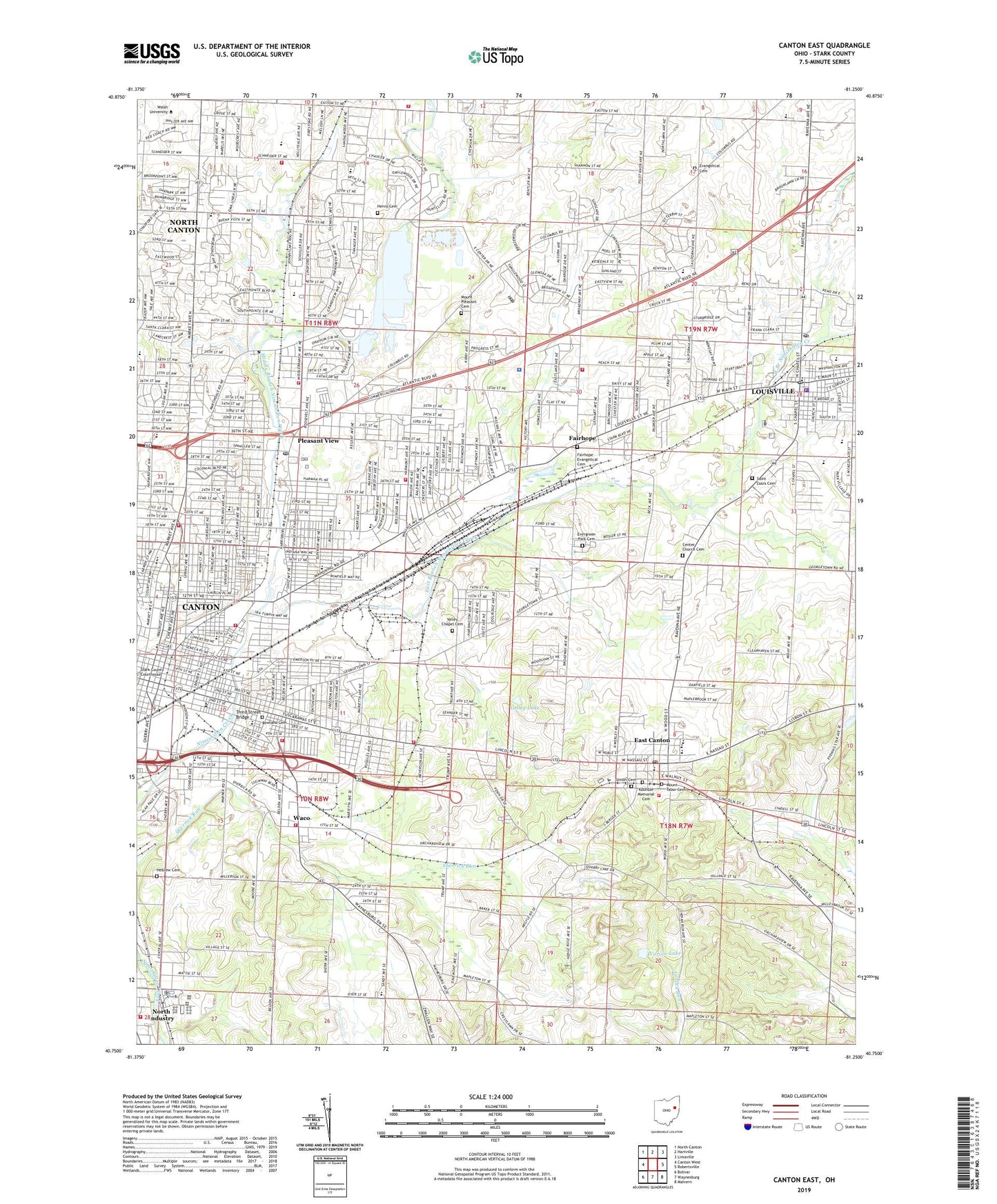
2019 topographic map quadrangle Canton East in the state of Ohio. Scale: 1:24000. Based on the newly updated USGS 7.5' US Topo map series, this map is in the following counties: Stark. The map contains contour data, water features, and other items you are used to seeing on USGS maps, but also has updated roads and other features. This is the next generation of topographic maps. Printed on high-quality waterproof paper with UV fade-resistant inks.
Quads adjacent to this one:
West: Canton West
Northwest: North Canton
North: Hartville
Northeast: Limaville
East: Robertsville
Southeast: Malvern
South: Waynesburg
Southwest: Bolivar
Contains the following named places: Agudas Achim Temple, Allen Elementary School, Amos McDaniel Elementary School, Anchor Mobile Home Park, Antioch Baptist Church, Belden Elementary School, Belle-Stone Elementary School, Bethany Evangelical United Brethren Church, Bethel Christian Methodist Episcopal Church, Board Street Park, Bors Field, Burns Elementary School, Calvary United Methodist Church, Calvin Presbyterian Church, Canton Country Day School, Canton Fire Department Station 2, Canton Fire Department Station 6, Canton Fire Department Station 7, Canton Fire Department Station 9, Canton Township Fire Department Station 1, Canton Township Fire Department Station 2, Canton Township Fire Department Station 4, Carousel Plaza Shopping Center, Center Church Cemetery, Center Church of the Brethren, Charles L Warstler Elementary School, Cherry Avenue Christian Church, Christ Lutheran Church, Circle Hawk Farm, City of Canton, City of Louisville, Clear View Heights, Constitution Park, Cook Park, Crenshaw Junior High School, Crystal Park, East Branch Nimishillen Creek, East Canton, East Canton Elementary School, East Canton High School, East Canton Post Office, East Orchard, Eastgate School, Emergency Medical Transport Station 100, Emergency Medical Transport Station 101, Evangelical Cemetery, Evergreen Park Cemetery, Fairhope, Fairhope Elementary School, Fairhope Evangelical Cemetery, Fairhope Evangelical United Brethren Church, Fairhope Post Office, Fairmount Elementary School, Fairmount Park United Presbyterian Church, First Brethren Church, First Church of God, First Lutheran Church, First United Church of Christ, Frazer Elementary School, Giant Auto Drive-In, Gibbs Elementary School, Gideon Church, Gospel Tabernacle, Grace Evangelical United Brethren Church, Greenwood Christian Church, Grenshaw Park, Harmont Park, Hartford Junior High School, Harvard Park, Hebrew Cemetery, Henry Cemetery, Herbruck Park, Holy Trinity Greek Orthodox Church, Horace Mann School, Ida Park, Jackson Park, Kinsey Farms, Kountze Memorial Cemetery, Louisville, Louisville Baptist Temple, Louisville City Hall, Louisville Elementary School, Louisville Fire Department, Louisville High School, Louisville Junior High School, Louisville Mobile Park, Louisville Police Department, Louisville Post Office, Louisville Public Library, Louisville United Brethren Church, Lynn Center Park, Madge Youtz Branch Stark County Library, Mahoning Road Plaza, Maple Avenue Church of the Brethren, Maple Park, Market Heights United Church of Christ, Marks, Martin Field, Martin Luther Lutheran Church, Martin School, Martindale Park, Mason Elementary School, McKinley High School, McKinley Wesleyan Methodist Church, Meadow Lake Golf Club, Memorial Park, Mercy Hospital, Metzger Park, Middle Branch Nimishillen Creek, Moreland, Moreland Church, Mount Pleasant Cemetery, Mount Tabor Cemetery, Mount Tabor United Methodist Church, Mount Zion Missionary Church, National First Ladies' Library Education and Research Center, Nimishillen Township Fire Department Station 1, Nimisilla Park, Ninth Street Church of God, North Nimishillen School, Northeast Waterworks Post Office, Oak Park, Oakwood High School, Orchard Heights, Osnaburg Township Fire Department, Our Savior Lutheran Church, Paradise United Church of Christ, Plain, Plain Center Elementary School, Plain Township Fire and Rescue Station 2, Plain Township Fire Department Station 4, Pleasant View, Pleasant View School, Pleasant View Village, Ransom Barr Elementary School, Rearick Park, Reifsnyder Park, Renkert Building, Richmond Mobile Home Park, Ridgewood Historic District, Riverside Park, Rowland Cemetery, Saint Anthonys Catholic Church, Saint Anthonys School, Saint Benedicts Catholic Church, Saint Benedicts School, Saint George Syrian Orthodox Church, Saint Haralambos Greek Orthodox Church, Saint Josephs Hospice, Saint Louis Catholic Church, Saint Louis Cemetery, Saint Louis School, Saint Marks Church, Saint Nicholas Ukrainian Catholic Church, Saint Pauls Catholic Church, Saint Pauls School, Saint Pauls United Church of Christ, Saint Peter Church, Saint Peters School, Saint Thomas Aquinas High School, Sancta Clara Monastery, Shaaray Torah Synagogue, Shady Knoll Mobile Park, Shanafelt Field, Simpson Church, Skyland Pines Golf Club, South Canton Community Church, Stark County, Stark County Christian Academy, Stark County Sheriff Heliport, Stark County Sheriff's Office, Theo Roosevelt School, Third Street Bridge, Thunderbird Terrace, Tip-Top Mart Shopping Center, Township of Canton, Township of Osnaburg, Township of Plain, Trinity Church, Trump, Trump Post Office, Trump School, Union Cemetery, Upper Downtown Canton Historic District, Valley Chapel, Valley Chapel Cemetery, Valley Lake, Varian Lake, Varian Lake Dam, Varian Orchards, Village of East Canton, Waco, Waco Post Office, Waco School, Walker Junior High School, Walnut Street Church of Christ, Walsh College, Washington Elementary School, WDLI-TV (Canton), Wildwood Park, Willig Park, Willow Brook Heights, Wilson Park, WINW-AM (Canton), Youtz Elementary School, ZIP Codes: 44704, 44705, 44707, 44714, 44730