MyTopo
Lakewood Ohio US Topo Map
Couldn't load pickup availability
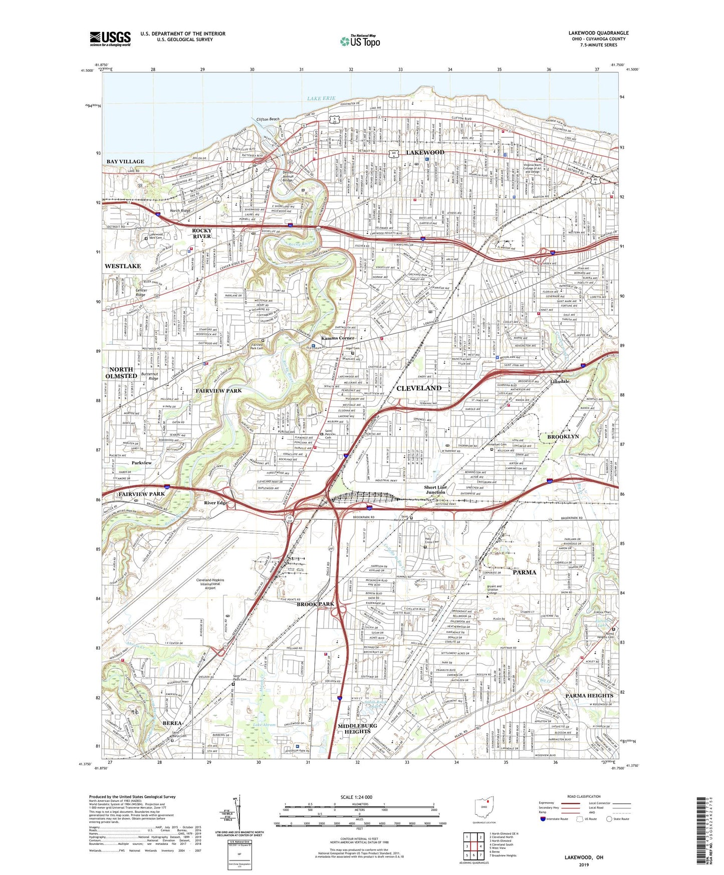
2019 topographic map quadrangle Lakewood in the state of Ohio. Scale: 1:24000. Based on the newly updated USGS 7.5' US Topo map series, this map is in the following counties: Cuyahoga. The map contains contour data, water features, and other items you are used to seeing on USGS maps, but also has updated roads and other features. This is the next generation of topographic maps. Printed on high-quality waterproof paper with UV fade-resistant inks.
Quads adjacent to this one:
West: North Olmsted
Northwest: North Olmsted OE N
Northeast: Cleveland North
East: Cleveland South
Southeast: Broadview Heights
South: Berea
Southwest: West View
Contains the following named places: 1st District Police Station Heliport, 44107, 44111, 44116, 44126, 44130, 44135, 44142, Abram Creek, Academy of Saint Adalbert, Alcott School, Alger Cemetery, Almira Elementary School, Annunciation School, Artemus Ward Elementary School, Ascension School, Assumption School, Auto Drive-In, Bates School, Beach School, Beachcliff Market Square Shopping Center, Berea Falls Scenic Overlook, Big Creek Parkway, Big Creek Reservation, Big Met Golf Course, Birds Nest, Birdtown Historic District, Bohlken Park, Brobst School, Brook Park, Brook Park Mobile Home Park, Brookgate Shopping Center, Brooklawn Elementary School, Burrell Observatory, Chevy Branch Big Creek, City of Brook Park, City of Brooklyn Landfill, City of Fairview Park, City of Lakewood, City of Parma Heights, City of Rocky River, Cleveland Lakefront State Park, Cleveland Metroparks Ranger Department, Cleveland Yacht Club, Cleveland-Hopkins International Airport, Clifton Beach, Clifton Lagoon, Clifton Park, Clifton Park Lakefront Historic District, Coe Creek, Coffinberry School, Colleda Branch Big Creek, Community Christian Academy, Cottonwood Picnic Area, Countrymans Creek, Cove Park, CPC Parma Heliport, Crossburn Playground, Cudell, Cudell Park, Cudell Recreation Center, Davies School, Detroit Avenue Bridge, Detroit-Linda Shopping Center, Dora Lee Payne Park, East Branch Big Creek, Eddys Boat Harbor, Edwards Park, Elmwood Playground, Emerson Middle School, Emery Park, Eureka Lake, Fairview High School, Fairview Hospital, Fairview Park, Fairview Park Cemetery, Fairwood Shopping Center, Fern Hill Picnic Area, Ford Hospital, Ford Intermediate School, Forrest School, Franklin Elementary School, Fruitland School, Garfield Elementary School, Garnett Elementary School, Gilles-Sweet School, Gilmore Playground, Glenbeigh Hospital, Glenn Research Center, Goldwood School, Grace Hospital Fairview, Grace Hospital Lakewood, Grant Elementary School, Greenbriar Junior High School, Greenbriar Plaza Shopping Center, Gresham, Gunning Playground, Halloran Park, Harding Middle School, Harrison Elementary School, Hayes Elementary School, Holy Cross Cemetery, Horace Mann Middle School, Hunters Point, Immanuel Cemetery, Impet Park, Incarnate Word Academy, James Hanna Park, Jefferson Park, John Mucklo Park, Johnson School, Kamms Corner, Kamms Plaza Shopping Center, Kauffman Park, Kensington School, Kronheims Plaza Shopping Center, Kurtz Park, Lake Abram, Lake Abram Metropolitan Reservation, Lakewood, Lakewood Catholic Academy, Lakewood High School, Lakewood Hospital, Lakewood Park, Lakewood Park Cemetery, Lewis F Mayer Middle School, Lincoln Elementary School, Linden Park, Linndale, Little Arabia, Little Met Golf Course, Longmead Elementary School, Louis Agassiz Elementary School, Lutheran High School West, Madison Elementary School, Madison Park, Magnificant High School, Marshall High School, Mastick Woods Golf Course, McKinley, McKinley Elementary School, Memorial Field, Memorial Field Park, Memphis Picnic Area, Midpark High School, Miller Playground, Mohican Playground, Mount Calvary School, Nathanial Hawthorne Elementary School, Neely Elementary School, Newton D Baker School of Arts, Nike Site CL-69L, North Linndale, North Mastick Picnic Area, Old District 10 Schoolhouse, Our Lady of the Angels School, Parkview, Parkview Elementary School, Parma Developmental Center School, Parma Heights, Parma Heights Cemetery, Parma Heights Park, Pearl-York Shopping Center, Puritas Springs Park, Raub School, Regency Hospital Company Cleveland West, River Edge, River Plaza Shopping Center, Riveredge Elementary School, Riverside Park, Robinson G Jones Elementary School, Rockport, Rockport Shopping Center, Rocky River, Rocky River High School, Rocky River Junior High School, Rocky River Reservation, Rocky River Shopping Center, Saint Angela Merici School, Saint Christophers School, Saint Clements School, Saint Edward High School, Saint Gregorys School, Saint Hedwigs School, Saint Ignatius School, Saint James School, Saint John Bosca School, Saint Lukes School, Saint Marks School, Saint Marys Cemetery, Saint Mels School, Saint Patricks Cemetery, Saint Patricks School, Saint Pauls Cemetery, Saint Rose of Lima School, Saint Vincents School, Scenic Park Picnic Area, Sea Shell Marina, Short Line Junction, Shuler Junior High School, Smith Road Lakes, Snow Road Picnic Area, Snowview School, Snowville Shopping Center, South Mastick Picnic Area, Southland Shopping Center, Stickney Creek, Stinchcomb Memorial, Stinchcomb-Groth Memorial Scenic Overlook, Stroud Park, Stroud School, Thrift City Shopping Center, Township of Riveredge, Tri-City Park, Tuland Playground, Tyler Field, Village of Linndale, Wagar Park, Warren Village Shopping Center, Washington School, Wedo Park, West Branch Big Creek, West Channel Rocky River, Westgate Shopping Center, Westlake Yachting Club, Westown Square Shopping Center, Westpark, Westwood Country Club, Westwood Town Center Shopping Center, Willow Bend Picnic Area, Wooster School, Wright Junior High School, Wright Nursing Center, Yorktown Green Park, Yorktown Shopping Center