MyTopo
Sidney Ohio US Topo Map
Couldn't load pickup availability
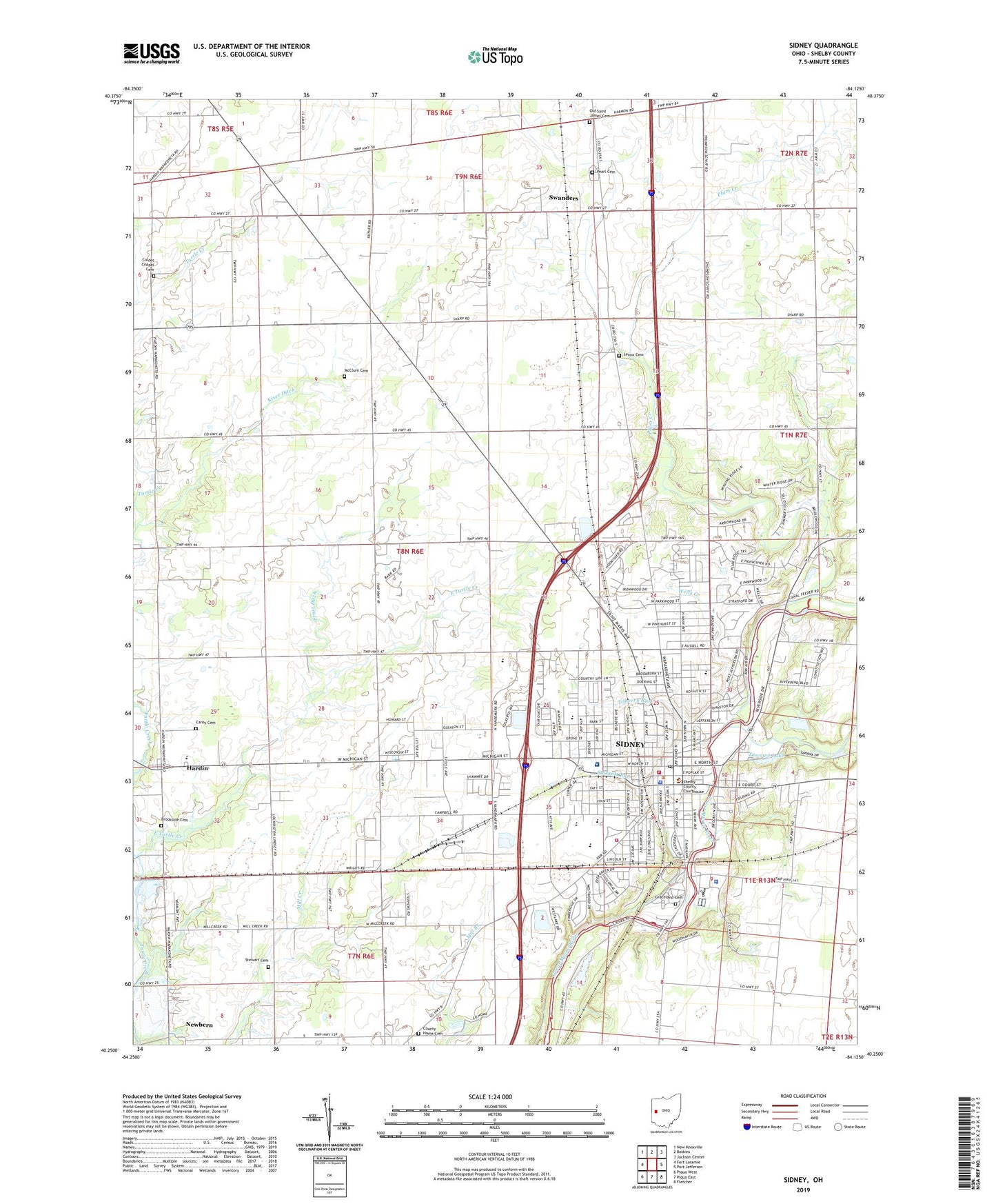
2019 topographic map quadrangle Sidney in the state of Ohio. Scale: 1:24000. Based on the newly updated USGS 7.5' US Topo map series, this map is in the following counties: Shelby. The map contains contour data, water features, and other items you are used to seeing on USGS maps, but also has updated roads and other features. This is the next generation of topographic maps. Printed on high-quality waterproof paper with UV fade-resistant inks.
Quads adjacent to this one:
West: Fort Loramie
Northwest: New Knoxville
North: Botkins
Northeast: Jackson Center
East: Port Jefferson
Southeast: Fletcher
South: Piqua East
Southwest: Piqua West
Contains the following named places: Amos Memorial Library, Auto Vue Drive-In, Beechwood School, Berger Park, Berning Farms, Bethel Mission Assembly of God Church, Brick Barn Garden Center, Bridgeview Middle School, Brookside Cemetery, Buckeye Terrace, Carey Cemetery, Central Elementary School, Christopher Northbrook Mobile Home Park, Church of Christ, Church of God, City of Sidney, City of Sidney Wastewater Treatment Plant, Civic Park, Coldes Chapel Cemetery, County Home Cemetery, Cuba School, Custenborder Field, D and S Mobile Village, Deam Park, Deweese School, East Turtle Creek, Ella Schenck Memorial United Brethren Church, Emerson Elementary School, Ernst Ditch, Faith Fellowship Church, First Baptist Church, First Presbyterian Church, First United Methodist Church, Graceland Cemetery, Green Tree Park, Hardin, Hardin Elementary School, Hardin Station, Harmon Park, Highland Park, Holy Angels Catholic Church, Holy Angels High School, Holy Angels School, House of Prayer Church, Humphrey Park, Kiser Ditch, Lakeside Village, Lenox Cemetery, Longfellow Elementary School, Lowell Elementary School, McClure Cemetery, Miami Erie Feeder Canal, Mount Vernon Baptist Church, Mount Victory School, Newbern, Northland Church of Christ, Northwood Middle School, Northwood Mobile Home Park, ODOT Heliport, Old Saint James Cemetery, Orbison Park, Parkwood Elementary School, Pearl Cemetery, Peerless Park, Plum Creek, Praise Temple Assembly of God Church, Redeemer Lutheran Church, Riverbend Park, Riverside Mobile Home Park, Riverside Park, Russell School, Saint Johns Lutheran Church, Saint Marks Episcopal Church, Saint Pauls United Church of Christ, School Number 1, School Number 2, School Number 3, School Number 5, School Number 7, Shelby County, Shelby County Childrens Home, Shelby County Courthouse, Shelby County Fairgrounds, Shelby County Fire Department, Shelby County Jail, Shelby County Sheriff's Office, Shelby Hills School for the Retarded, Sherman Park, Sidney, Sidney City Municipal Court, Sidney Courthouse Square Historic District, Sidney Department of Fire and Emergency Services Station 1, Sidney Fire and Emergency Services Station 2, Sidney High School, Sidney Police Department, Sidney Post Office, Sidney Theatre, Sidney Walnut Avenue Historic District, Sidney Water Works, Starrett Run, Stephen Brown Park, Stewart Cemetery, Swanders, Swanders Post Office, Tawawa Lake, Tilberry Run, Township of Clinton, Township of Franklin, Township of Turtle Creek, United Missionary Church, Washington School, Wells Creek, White Feather Ditch, Whittier Elementary School, Wilson Memorial Hospital, WMVR-AM (Sidney), WMVR-FM (Sidney), ZIP Code: 45365