MyTopo
James Island South Carolina US Topo Map
Couldn't load pickup availability
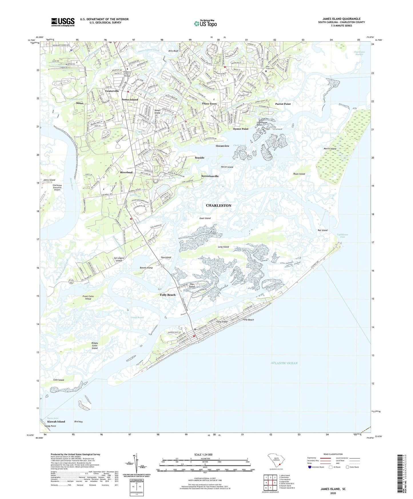
2020 topographic map quadrangle James Island in the state of South Carolina. Scale: 1:24000. Based on the newly updated USGS 7.5' US Topo map series, this map is in the following counties: Charleston. The map contains contour data, water features, and other items you are used to seeing on USGS maps, but also has updated roads and other features. This is the next generation of topographic maps. Printed on high-quality waterproof paper with UV fade-resistant inks.
Quads adjacent to this one:
West: Legareville
Northwest: Johns Island
North: Charleston
Northeast: Fort Moultrie
East: James Island OE E
South: Kiawah Island OE E
Southwest: Kiawah Island
Contains the following named places: Bass Creek, Battery Point, Bayfront, Bird Key, Black Island, Block Island Creek, Bowen Island, Bur Clare, Camp Road Estates, Centerville, Charleston County Public Library James Island Branch Library, Charleston Lighthouse, City of Charleston Fire Department Station 7, City of Folly Beach, Clark Sound, Clarks Point, Clarks Sound, Cole Creek, Cole Island, Creek Point, Cut Ridge School, Cutoff Reach, Dellwood, Dills Bluff, Downs Creek, Farmington, First Sister Creek, Folly Beach, Folly Beach Fire Department, Folly Beach Library, Folly Beach Police Department, Folly Beach Post Office, Folly Beach Town Hall, Folly Creek, Folly Island, Folly River, Fort Johnson Creek, Fort Johnson Estates, Fort Johnson Middle School, Front Coles Island, Goat Island, Green Hill, Greencrest, Grimball Shores, Harbor View Shopping Center, Harbor Woods, Heron Island, Holiday Acres, Holy Cross Cemetery, Honey Hill, Island Plaza, James Island, James Island Charter High School, James Island Division, James Island Elementary School, James Island Fire Department Station, James Island Fire Department Station 2, James Island Fire Department Station 4, James Island Magistrate Court Law Enforcemenet Police Station, James Island Magistrate Office, James Island Middle School, James Island Post Office, Jamestown Estates, King Flats Creek, Kings Acres, Kings Road School, Lakeview of Lawton Bluff, Landsdowne, Lawton Bluff, Lee Jackson Estates, Lighthouse Creek, Lighthouse Inlet, Lighthouse Point, Lockwood Hall, Long Island, Lynnwood, Mariners Cay Racquet and Yacht Club, Marsh Point, McCalls Corner, Meggett School, Middle Coles Island, Morris Island, Murray - Lasaine Elementary School, Nativity School, Newtown Cut, North Windmill, Oak Island, Oak Island Creek, Oakcrest, Oakview Park, Oceanview, Old Orchard, Oswald Place, Oyster Point, Parrot Point, Parrot Point Creek, Pea Island, Quail Run, Queensborough, Rat Island, Rat Island Creek, Riverland, Riverpoint, Riverview, Robbins Creek, Saint James Church, Saint James School, Schooner Creek, Seaside, Seaside Creek, Secessionville, Secessionville Acres, Secessionville Creek, Secessionville Historic District, Second Sister Creek, Septima P Clark Corporate Academy, Simpson Creek, Society Corner School, Sol Legare Island, South Windmill, Stephen Washington Park, Stiles Point, Stiles Point Elementary School, Stono, Stono Inlet, Teal Acres, Three Trees, Tidalview, Town of James Island, Westchester, Whitehall Plantation, Whitehouse Plantation, Wolfpit Run, Woodhaven, ZIP Codes: 29412, 29439