MyTopo
Ora South Carolina US Topo Map
Couldn't load pickup availability
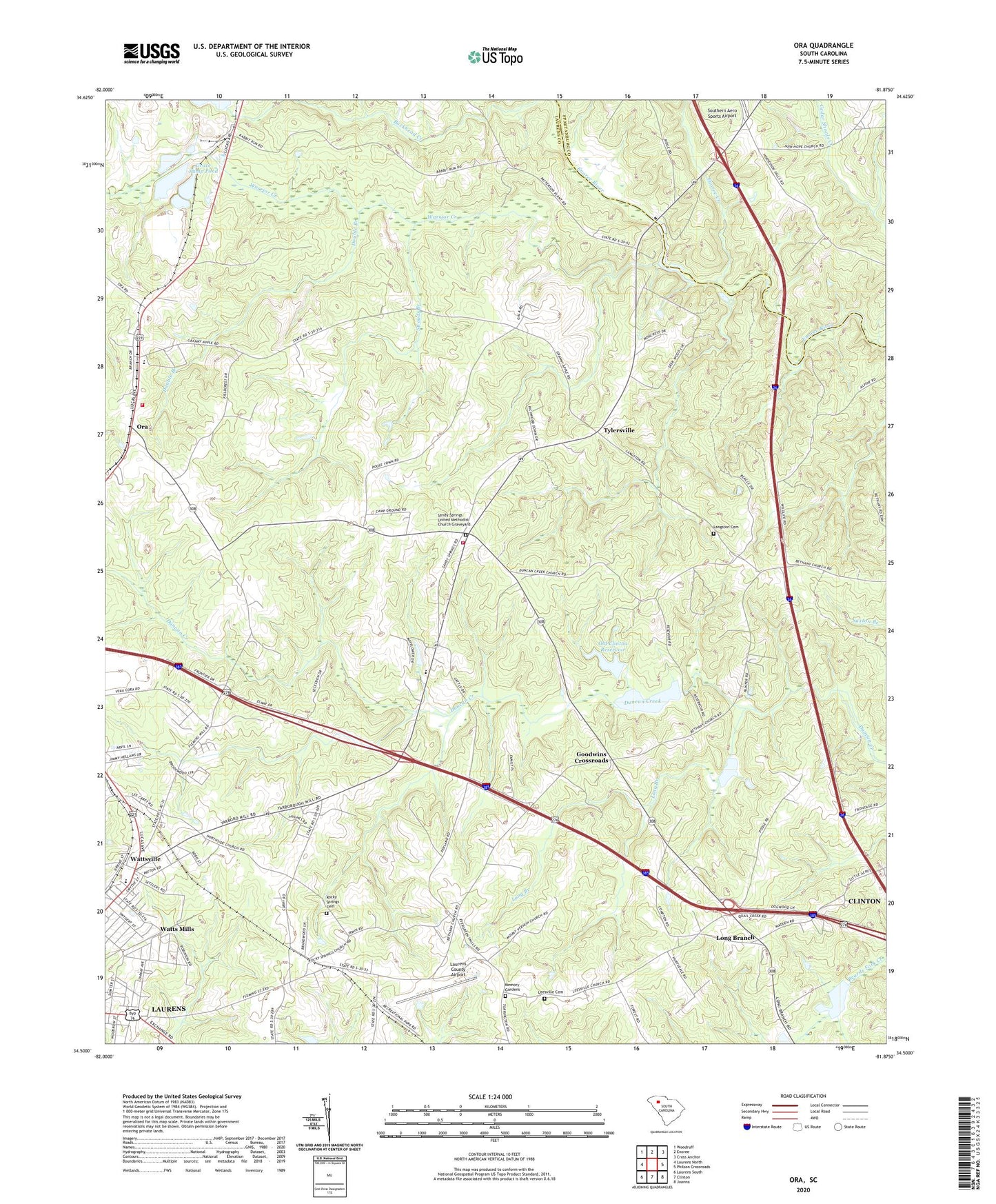
2020 topographic map quadrangle Ora in the state of South Carolina. Scale: 1:24000. Based on the newly updated USGS 7.5' US Topo map series, this map is in the following counties: Laurens, Spartanburg. The map contains contour data, water features, and other items you are used to seeing on USGS maps, but also has updated roads and other features. This is the next generation of topographic maps. Printed on high-quality waterproof paper with UV fade-resistant inks.
Quads adjacent to this one:
West: Laurens North
Northwest: Woodruff
North: Enoree
Northeast: Cross Anchor
East: Philson Crossroads
Southeast: Joanna
South: Clinton
Southwest: Laurens South
Contains the following named places: Barksdale Field, Beaverdam Warrior WCD Dam 33 D-2982, Bellview Church, Carolina Cow Country Airport, Claytons Recreational Park Pond, Clinton 308 Pond Dam D-2988, Conchs Mill, Copeland School, Double Branch, Duncan Creek Church, Duncan Creek School, Duncan Creek Watershed Number 6b Reservoir, Duncan Creek Watershed Two Reservoir, Eastside Church, Enoree Creek, Ford School, Garlington Street Grammar School, Goodwins Crossroads, Grace Pump Pond, Grace Pump Pond Dam D-2978, Grace Second Sediment Pond, Jamie Penell Memorial Park, Langston Cemetery, Langston Church, Langston School, Laurens County Airport, Laurens County Fire Department Sandy Springs, Laurens County Fire Department Sandy Springs Station 2, Laurens County Home, Leesville Cemetery, Leesville Church, Long Branch, Long Branch Church, Long Branch School, Memory Gardens, Montgomery School, Mount Vernon Church, Mount Vernon School, Northside Church, Oak Grove School, Old Clinton Reservoir, Old Fields Presbyterian Church, Ora, Ora Associate Reformed Presbyterian Church, Ora Presbyterian Church Graveyard, Pisgah Church, Pool Town, Rock Hill School, Rocky Springs Cemetery, Rocky Springs Church, Sandy Ford, Sandy Springs Church, Sandy Springs School, Sandy Springs United Methodist Church Graveyard, South Carolina Noname 30002 D-2986 Dam, South Carolina Noname 30006 D-2984 Dam, South Carolina Noname 30010 D-2983 Dam, South Carolina Noname 30013 D-2977 Dam, South Carolina Noname 30020 D-2980 Dam, South Carolina Noname 42024 D-2726 Dam, Strouds Branch, Tylersville, Warrior Creek, Waste Stabilization 308 Pond, Watts Mills Census Designated Place, Wattsville, Wattsville Pentecostal Holiness Church, Wests Mills, Yarboroughs Bridge, Zoar School