MyTopo
Mount Vernon Tennessee US Topo Map
Couldn't load pickup availability
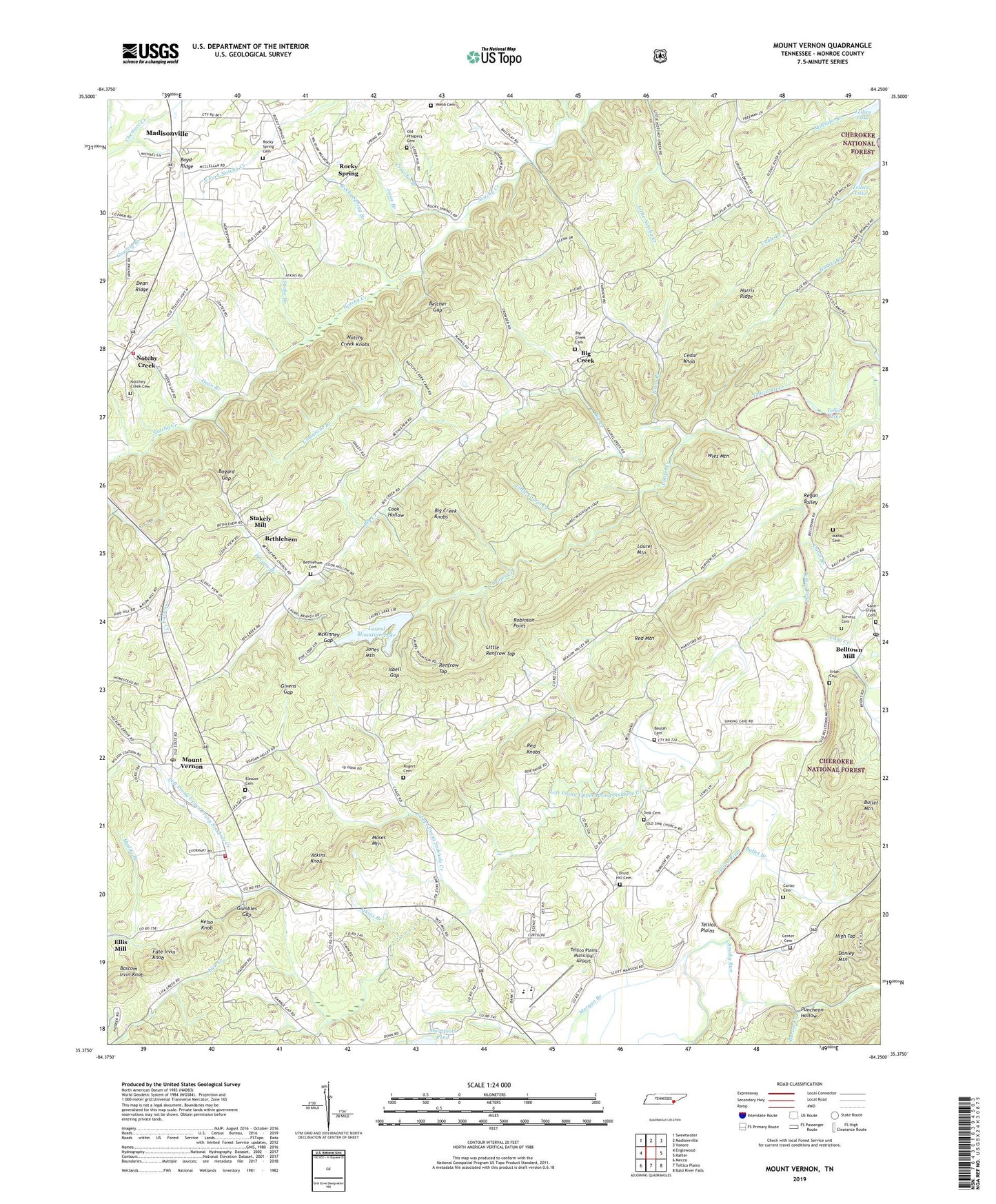
2019 topographic map quadrangle Mount Vernon in the state of Tennessee. Scale: 1:24000. Based on the newly updated USGS 7.5' US Topo map series, this map is in the following counties: Monroe. The map contains contour data, water features, and other items you are used to seeing on USGS maps, but also has updated roads and other features. This is the next generation of topographic maps. Printed on high-quality waterproof paper with UV fade-resistant inks.
Quads adjacent to this one:
West: Englewood
Northwest: Sweetwater
North: Madisonville
Northeast: Vonore
East: Rafter
Southeast: Bald River Falls
South: Tellico Plains
Southwest: Mecca
Contains the following named places: Atkins Branch, Atkins Knob, Barum Creek, Bascom Irvin Knob, Belcher Gap, Belltown, Belltown Mill, Belltown Post Office, Bethlehem, Bethlehem Baptist Church, Bethlehem Cemetery, Bethlehem School, Beulah Cemetery, Beulah Church, Big Creek, Big Creek Baptist Church, Big Creek Cemetery, Big Creek Knobs, Big Creek School, Bogard Gap, Boyd Ridge, Bullet Branch, Bullet Mountain, Cane Creek, Cane Creek Baptist Church, Cane Creek Cemetery, Cane Creek School, Carter Cemetery, Cedar Grove School, Cedar Knob, Center, Center Presbyterian Church, Center Presbyterian Church Cemetery, Center School, Chickasaw Branch, Comanche Branch, Connahanee School, Cook Hollow, Crowder Branch, Davis Branch, Dean Branch, Dean Ridge, Donley Mountain, Druid Hill Cemetery, Druid Hills Baptist Church, Eleazar United Methodist Church, Eleazer Cemetery, Ellis Mill, Fairview Baptist Church, Fairview School, Fate Irvin Knob, Gambles Gap, Givens Gap, Green Hill School, Harris Ridge, Hicks School, High Top, Isbell Gap, Ivans Branch, Jones Branch, Jones Mountain, Kelso Knob, Laurel Creek, Laurel Mountain, Laurel Mountain Dam, Laurel Mountain Lake, Left Prong Upper Prong Sinkhole Creek, Little Laurel Creek, Little Renfrow Top, Lulah Cemetery, Lulah Church, Mahan Cemetery, McKinney Gap, Monroe County, Morgan Branch, Moses Mountain, Mount Harmony, Mount Harmony Baptist Church, Mount Harmony School, Mount Vernon, Mount Vernon Baptist Church, Mount Vernon Post Office, Mount Vernon Quarry, Mount Vernon School, Mount Vernon Volunteer Fire Department, Muddy Branch, Nars Ford, New Providence Church, Notchey Creek Baptist Church, Notchey Creek Cemetery, Notchey Creek School, Notchey Creek Volunteer Fire Department, Notchy Creek, Notchy Creek Knobs, Old Prospect Cemetery, Piney Grove Church, Possum Branch, Puncheon Hollow, Red Knobs, Red Mountain, Regan Valley, Renfrow Top, Robinson Point, Rocky Spring, Rocky Spring Branch, Rocky Spring Cemetery, Rocky Springs Baptist Church, Rogers Cemetery, Rogers Station, Shortfoots Pond, Sink, Sink Cemetery, Sink Church, Sink School, Sinkhole Creek, Smoky Run, Snake Branch, Stakely Mill, Stevens Cemetery, Tellico Camp, Tellico Plains, Tellico Plains High School, Tellico Plains Junior High School, Tellico Plains Municipal Airport, Tevis, Tevis Spring Church, Tom Station, Union Hall, Union Hall Baptist Church, Union Hall School, Upper Prong Sinkhole Creek, Webb Cemetery, Wies Mountain