MyTopo
Mesquite Texas US Topo Map
Couldn't load pickup availability
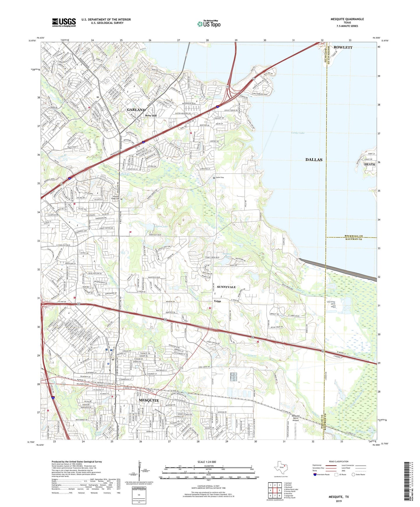
2019 topographic map quadrangle Mesquite in the state of Texas. Scale: 1:24000. Based on the newly updated USGS 7.5' US Topo map series, this map is in the following counties: Dallas, Kaufman, Rockwall. The map contains contour data, water features, and other items you are used to seeing on USGS maps, but also has updated roads and other features. This is the next generation of topographic maps. Printed on high-quality waterproof paper with UV fade-resistant inks.
Quads adjacent to this one:
West: White Rock Lake
Northwest: Garland
North: Rowlett
Northeast: Rockwall
East: Forney North
Southeast: Forney South
South: Seagoville
Southwest: Hutchins
Contains the following named places: Ablon Park, Agnew Junior High School, Agnew Middle School, Agnew Park, Audubon Park Recreation Center, Audubon Village Shopping Center, Baptista Mission Peregrino Church, Beacon Hill Baptist Church, Belt Line Church, Bethany Apostolic Church, Big Town Heliport, Black Elementary School, Blessed Sacrament Old Roman Catholic Church, Buffalo Creek, C W Beasley Elementary School, Carter Softball Complex at Audubon Park, Carver School, Church of Christ - Meadow View, Church of Christ Robin Road, City of Garland Duck Creek Wastewater Treatment Plant, City of Mesquite, Classical Center at Brandenburg Middle School, Cody Park, Dallas Regional Medical Center, Duck Creek, Duck Creek Greenbelt Trail, E H Hanby stadium, Eastern Hills Baptist Church, Eastern Hills Church of Christ, Eastern Hills Golf Course, Eastern Hills Park, Emmanuel Pentecostal Church, E-S Ranch, Faith Missionary Baptist Church, Faulkner Point Heliport, First Response Emergency Medical Services, Florence Black School, Four Square Gospel Fellowship Church, Freedom Park, Garland Fire Department Station 4, Garland Fire Department Station 5, Gatewood Baptist Church, Gatewood Park, Georgia W Kimball Elementary School, Grace Baptist Church, Grace Episcopal Church, Green Brook Park, Handley Elementary School, Hillcrest Park, Hilltop Church, Holy Trinity Episcopal Church, J C Austin Elementary School, J C Cannaday Elementary School, John Hanby Elementary School, John T Audobon Park, Lakeview Centennial High School, Life Community Church, Lifetime Emergency Medical Services, Light Crust Doughboys Hall of Fame Museum, Lighthouse Baptist Fellowship Church, Long Branch, Long Creek, Long Creek Church, Lupton Farms Heliport, Lupton Lake, Lupton Lake Dam, Lyles Middle School, Lyons Cemetery, Lyons Road Baptist Church, Macedonia Church, Mary Moss Elementary School, Mathew Lake, Mathew Lake Dam, Mesquite, Mesquite Church of God, Mesquite City Hall, Mesquite Fire Department Station 1, Mesquite Fire Department Station 4, Mesquite Fire Department Station 5, Mesquite Fire Department Station 6, Mesquite First Church of the Nazarene, Mesquite High School, Mesquite Police Department, Mesquite Post Office, Mesquite Seventh Day Adventist Church, Mesquite Specialty Hospital, Metroplex East Baptist Church, Muddy Creek, New Covenant Baptist Church, New Hope, New Hope Baptist Church, New Jerusalem Church of God, Northridge Church, Oak Tree Baptist Church, Oaks Branch Park, O'Banion Park, Open Door Baptist Church, Parschall Park, Paschall Park Trail, Pentecostal Church of God Christian Assembly, Pleasant Ridge Cemetery, Porter Elementary School, Praise Temple Assembly of God Church, R S Kimbrough Middle School, Ralph H Poteet High School, Rockwall-Forney Dam, Rockwell-Forney Dam, Rose Hill, Rosehill Park, Ross Park, Rowlett Creek, Ruby Shaw Elementary School, Rush Creek, Rutherford Elementary School, Rutherford Park, Saint Thomas Aquinas Catholic Church, Sampeck Lake, Sampeck Lake Dam, Samuell Mesquite Park, Samuell New Hope Park Site, Shugart Elementary School, Skyline Assembly of God Church, South Garland High School, South Garland Post Office, Sunnyvale, Sunnyvale Elementary School, Sunnyvale Fire Department Station 1, Sunnyvale Fire Department Station 3, Sunnyvale Middle School, Sunnyvale Town Hall, Sunnyvale Volunteer Fire Department, Texas Highway Patrol Office, Texas Highway Patrol Office - Garland, The Church of Jesus Christ of Latter Day Saints, The Medical Center of Mesquite Heliport, Tisinger Elementary School, Tisinger Park, Toler Elementary School, Tosch Lake, Tosch Lake Dam, Town East Centre, Town East Mall Shopping Center, Town of Sunnyvale, Travis Williams Softball Complex, Tree of Life Lutheran Church, Tripp, Tripp Baptist Church, Vernon Primary and Elementary School, Vial Elementary School, Victory New Testament Fellowship Church, West Lake Community Church, West Lake Park, Wildwood Church, Wilkinson Middle School, Yankee Creek, ZIP Codes: 75043, 75149, 75182