MyTopo
San Antonio East Texas US Topo Map
Couldn't load pickup availability
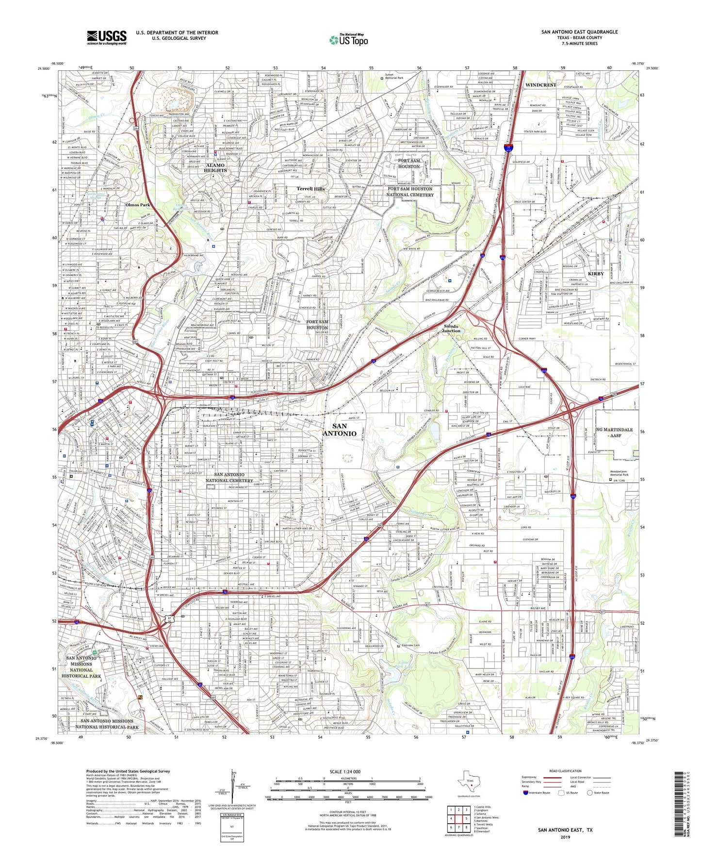
2019 topographic map quadrangle San Antonio East in the state of Texas. Scale: 1:24000. Based on the newly updated USGS 7.5' US Topo map series, this map is in the following counties: Bexar. The map contains contour data, water features, and other items you are used to seeing on USGS maps, but also has updated roads and other features. This is the next generation of topographic maps. Printed on high-quality waterproof paper with UV fade-resistant inks.
Quads adjacent to this one:
West: San Antonio West
Northwest: Castle Hills
North: Longhorn
Northeast: Schertz
East: Martinez
Southeast: Elmendorf
South: Southton
Southwest: Terrell Wells
Contains the following named places: Alamo Heights, Alamo Plaza, Alamo Plaza Historic District, Alamo Stadium, Alamodome, Baptist Medical Center, Baptist Medical Center Heliport, Belmeade Park, Blessed Sacrament Academy, Blue Star Street Industrial Historic District, Brackenridge High School, Brackenridge Park, Burnet School, Button Stadim, Cambridge School, Camelot Development Lake, Camelot Development Lake Dam, Camp Travis, Central High School, Chapman-Cowles Fountain and Sculpture, Charles L Kelly Army Heliport, Christus Santa Rosa Childrens Hospital, CHRISTUS Santa Rosa Children's Hospital, City of Alamo Heights, City of Kirby, City of Olmos Park, City of Terrell Hills, Coates Esplanade, Cole High School, Cole Stadium, Columbus Park, Comanche Park, Commanders House Park, Communications Tower, Concepcion Park, Copernicus Park, Crockett Square, Cuney School, Dafoste Park, Dawson Massacre Historical Monument, Del Rio Heliport, Delavan Tennis Stadium, Dellcrest Park, Dellcrest Plaza, Denver Heights Park, Denver Park, Dignowity Park, Douglas Junior High School, Durango Park, E M Stevens Field, E M Stevens Stadium, East Terrell Hills School, Eastview Cemetery, Edgar Allen Poe Junior High School, Fairchild Park, Fannin School, Fort Sam Houston, Fort Sam Houston National Cemetery, Fort Sam Houston School, Fox Tech High School, Friendship Park, Gates School, Green School, Harry B Orem Stadium, Haskin Park, Hawthorne High School, Healy-Murphy Park, Hemisfair Plaza, HemisFair Plaza, Hererra Park, Herff School, Herrera Park, Highland Hills School, Highland Park, Highland Park School, Highlands High School, Hirsch School, Hugo Lenzt Park, Hugo Linch Park, Incarnate Word Retirement Community, Ingram Park Mall, J Street Park, James Park, Japhet School, Jefferson Davis Junior High School, Jesse H Jones Recreation Area, John H Sterling Memorial Park, KAJA-FM (San Antonio), KCHL-AM (San Antonio), Kenwood Park, King William Historic District, King William Park, Kirby, Kirby City Park, KONO-AM (San Antonio), KQXT-FM (San Antonio), KRTU-FM (San Antonio), KSAT 12-TV Tower, KSYM-FM (San Antonio), KTFM-FM (San Antonio), KTSA-AM, KWEX-TV (San Antonio), KZEP-AM (San Antonio), KZEP-FM (San Antonio), La Villita Historic District, La Villita Park, Lamar School, Lang Field, Lincoln Barkmeyer Park, Lincoln Park, Lindberg Park, Lions Park Lake, Lions Park Lake Dam, Lockwood Park, Madison Square Park, Mahncke Park, Mahnke Park, Main and Military Plazas Historic District, Martin Luther King Park, Martindale Army Air Field, Maverick Park, McCreless Shopping Center, McKinley School, Meadowlawn Memorial Park, Metropolitan Methodist Hospital, Milam School, Milam Square, Miller School, Mission Concepcion, Mission Stadium, Monte Vista Residential Historic District, Morrill Park, Nix Medical Center, Northridge Park, Olmos Basin Park, Olmos Creek, Olmos Dam, Olmos Park, Olmos Reservoir, Onslow Park, Our Lady of Victory School, Page Junior High School, Pecan Valley Country Club, Pershing Creek, Pershing Park, Pershing School, Pheiffer School, Pitman Courts, Pittman-Sullivan Park, Plaza de las Islas, Pletz County Park, Providence High School, Radio Tower, Radio Towers, Riley Junior High School, Rittiman Creek, Rivercenter Mall Shopping Center, Riverside Golf Course, Riverside Park School, Romana Park, Roosevelt Park, Saint Anthony Junior Seminary, Saint Anthony School, Saint Anthony Shrine School, Saint Benedict School, Saint Cecilia School, Saint Gerard High School, Saint Gerard Junior High School, Saint Gerard School Alumni Field, Saint John School, Saint John Seminary, Saint Luke School, Saint Margaret Mary School, Saint Mary Hall, Saint Mary School, Saint Patrick School, Saint Paul School, Saint Peter-Saint Joseph Home, Saint Philips College, Saint Teresa Academy, Saint Thomas More School, Salado Junction, Salado Park, Sam Houston High School, San Antonio, San Antonio Botanical Garden, San Antonio College, San Antonio Country Club, San Antonio Division, San Antonio Military Medical Center - Brooke Army Medical Center, San Antonio National Cemetery, San Antonio Springs, San Pedro Creek, SBC Center, Second Baptist Church Park, Select Specialty Hospital - San Antonio, Skyline Park, Smith School, Sojourner School, South Alamo Street-South Marys Street Historic District, South Side Lions Park, South Side Lions Park East, Southern Pacific Depot Historic District, Southern Pacific Railroad Passenger Station, Steele School, Stephen F Austin School, Stewart School, Sunset Memorial Park, Terrell Hills, Terrell Plaza, Texas Military Institute, Travis Park, Travis School, Trinity University, Tynan School, University of the Incarnate Word, Victory Medical Center San Antonio, Walzem Creek, Washington School, Willow Springs Golf Course, Wilshire Terrace Park, Woodard Park, Yturri-Edmunds Historic Park, ZIP Codes: 78202, 78203, 78205, 78208, 78209, 78210, 78212, 78215, 78218, 78219, 78220, 78234