MyTopo
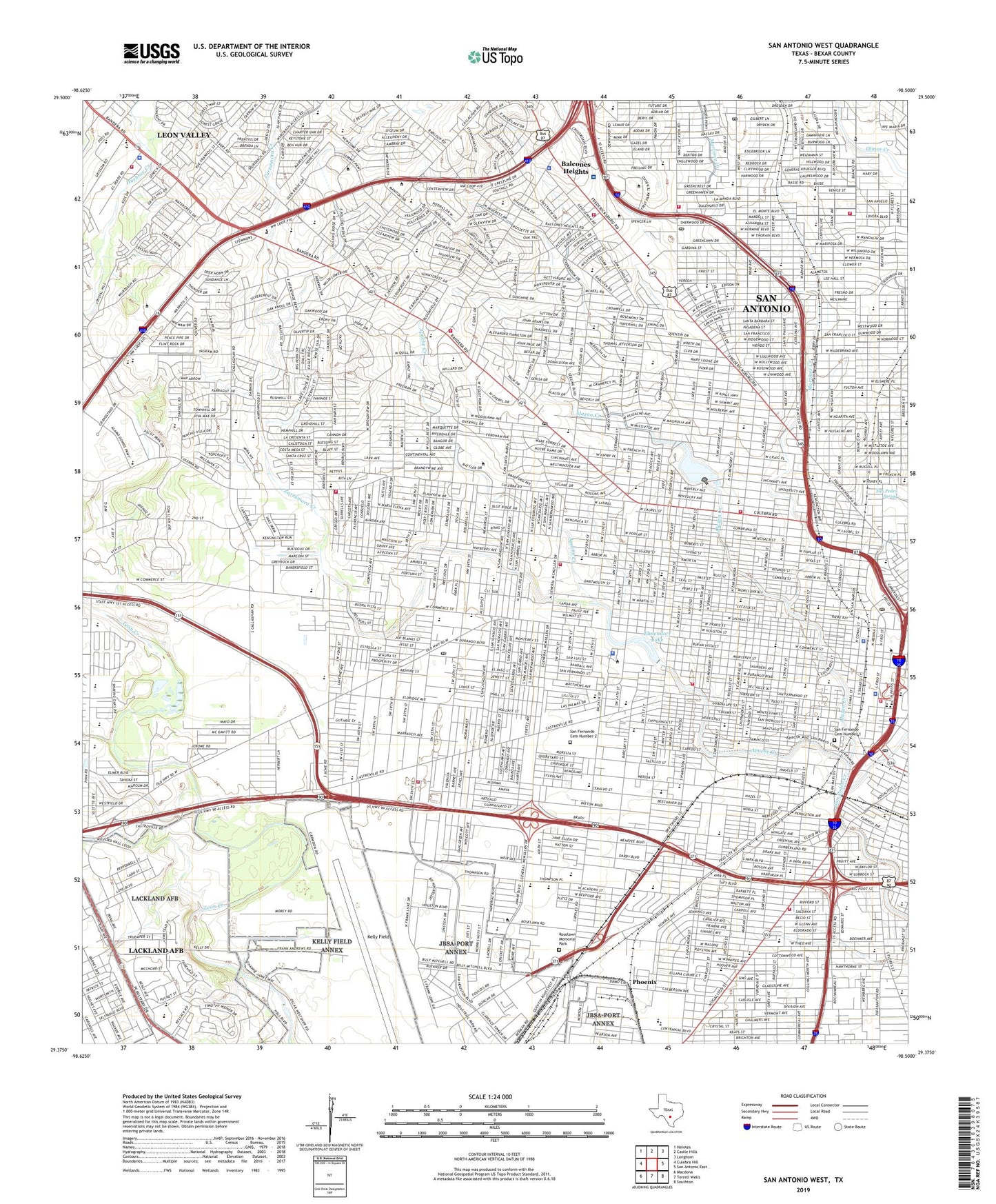
San Antonio West Texas US Topo Map
Couldn't load pickup availability
2019 topographic map quadrangle San Antonio West in the state of Texas. Scale: 1:24000. Based on the newly updated USGS 7.5' US Topo map series, this map is in the following counties: Bexar. The map contains contour data, water features, and other items you are used to seeing on USGS maps, but also has updated roads and other features. This is the next generation of topographic maps. Printed on high-quality waterproof paper with UV fade-resistant inks.
Quads adjacent to this one:
West: Culebra Hill
Northwest: Helotes
North: Castle Hills
Northeast: Longhorn
East: San Antonio East
Southeast: Southton
South: Terrell Wells
Southwest: Macdona
Contains the following named places: Accelerated Learning School, Acme Park, Agnes Cotton Elementary School, Alamo Achievement Center, Alamo Downs Racetrack, Alazan Creek, Alderette Park, Aldevete Park, Alonso S Perales Elementary School, Amistad Park, Anson Jones Middle School, Apache Creek, Apache Creek Park, Arnold Elementary School, Assumption Seminary, Balcones Heights, Balcones Heights City Park, Bandera Shopping Center, Barkley School, Baskin Elementary School, Baskin School, Beacon Hill Elementary School, Bexar County, Bowie School, Brackenridge School, Brady Park, Brentwood Junior High School, Brentwood Middle School, Brewer Elementary School, Brewer School, Briscoe Elementary School, Briscoe School, Buckeye Park, Burbank High School, Burleson Elementary School, Burleson School, Cable School, Callaghan School, Carvajal School, Cassiano Park, Catalina Park, Cenizo Park School, Centeno Park, Charles Arnold School, City of Balcones Heights, City of Leon Valley, City of San Antonio, Collins Garden Park, Collins Garden School, Concordia School, Cooper Junior High School, Coronado School, Cotton School, Crossroads Shopping Center of San Antonio, Cuellar Park, De Zavala School, Division Park, Dunbar School, Edgewood High School, Edgewood Junior High School, Edgewood Stadium, Edison High School, Elma Neal School, Elmendorf Lake, Elmendorf Lake Dam, Elmendorf Lake Park, Elmendorf Park, Emma Frey School, Escobar Junior High School, Estrella Mall Shopping Center, Farias Park, Father Timothy Benavides Park, Fenwick School, Garcia Junior High School, Gardendale School, Garza Park, Gilbert Garza Park, Glen Oaks Park, Glen Oaks School, Grace Hospital, Graebner School, Grant School, Green Hospital, Harris Junior High School, Harry Truman Junior High School, Hillcrest School, Hoelscher Elementary School, Holy Cross High School, Holy Cross of San Antonio School Baseball Field, Holy Cross Stadium, Holy Rosary High School, Horace Mann Junior High School, Huppertz School, Immaculate Conception School, Ingram Park Shopping Center, International Bible College, Irving Junior High School, Ivanhoe School, Jefferson High School, John F Kennedy High School, Johnson School, Jones Middle School, Kelly Air Force Base, Kelly Field, Kelly School, Kennedy Park, King School, Knox School, Lackland Air Force Base, Lackland Air Force Base Census Designated Place, Lackland Elementary School, Lackland High School, Lakeview School, Lanier High School, Las Palmas Elementary School, Las Palmas School, Lee's Creek Park, Leon Valley, Levi Strauss Park, Lincoln School, Lindbergh Park, Little Flower School, Loma Park School, Longfellow Junior High School, Lowell Junior High School, Lyndon B Johnson School, Margil School, Mark Twain Junior High School, Martinez Creek, Martinez Park, Mateo Camargo Park, Maverick School, Memorial High School, Methodist Texsan Hospital, Monterrey Park, Navarro Achievement Center, Navarro Park, Navarro School, Nazarene Seminary, Neal Elementary School, Neff Middle School, Nelson Elementary School, Nelson W Wolff San Antonio Municipal Stadium, Normoyle Park, Oak Hills Golf Course, Ogden Elementary School, Ogden School, Ojeda Park, Oliver W Holmes High School, Olmos Elementary School, Olmos School, Olympia Park, Our Lady of the Lake College, Pablos Grove Park, Palm Heights Park, Pat M Neff Junior High School, Peacock Military Academy, Phoenix, Produce Terminal Market, Redeemer School, Rhodes Junior High School, Rhodes Middle School, Rodriguez Elementary School, Rodriguez Park, Rogers Elementary School, Roosevelt Elementary School, Roosevelt School, Rosedale Park, Roselawn Memorial Park, Ross Junior High School, Ruiz Elementary School, Ruiz School, Saint Agnes School, Saint Francis Academy, Saint Gregory School, Saint James School, Saint John Berchmans School, Saint John Bosco School, Saint Leo School, Saint Lukes School, Saint Mary Magdalen School, Saint Marys University, Saint Paul School, Saint Philips College - Southwest Campus, Saint Timothy Park, San Antonio Central Division, San Fernando Cemetery Number 1, San Fernando Cemetery Number 2, San Juan Brady Park, San Pedro Park, San Pedro Spring, Santa Rosa Helistop, Seneca Country Club, Slick Ranch Creek, Southwest Research Institute, Stafford School, Stillman Park, Storm School, Strauss Park, Sunset Hills School, Tafolla Junior High School, Texas Diabetes Institute, Tobin Park, Trinidad School, Union Stock Yards, V J Keefe Stadium, Van de Walle Park, Vidaurri Park, West Elementary School, West End Park, West San Antonio Heights School, Whittier Junior High School, Wilford Hall Medical Center Heliport, Will Rogers School, Williams School, Wilson School, Winston School, Wonderland Shopping Center, Woodlawn Hills School, Woodlawn Hospital, Woodlawn Lake, Woodlawn Lake Dam, Woodlawn Park, Woodlawn School, Wrenn Middle School, Zarzamora Creek, ZIP Codes: 78201, 78204, 78207, 78225, 78226, 78228, 78236, 78237, 78238