MyTopo
Church Creek Maryland US Topo Map
Couldn't load pickup availability
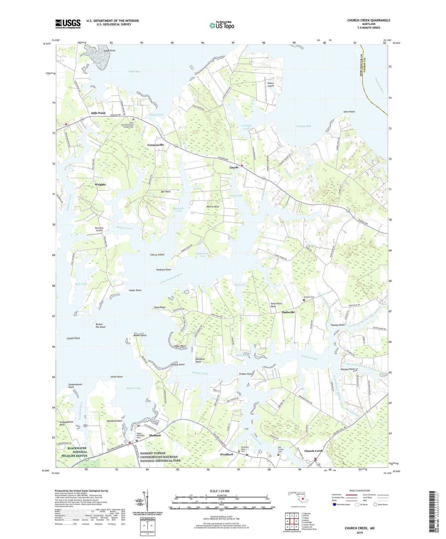
2019 topographic map quadrangle Church Creek in the state of Maryland. Scale: 1:24000. Based on the newly updated USGS 7.5' US Topo map series, this map is in the following counties: Dorchester, Talbot. The map contains contour data, water features, and other items you are used to seeing on USGS maps, but also has updated roads and other features. This is the next generation of topographic maps. Printed on high-quality waterproof paper with UV fade-resistant inks.
Quads adjacent to this one:
West: Hudson
Northwest: Tilghman
North: Oxford
Northeast: Trappe
East: Cambridge
Southeast: Blackwater River
South: Golden Hill
Southwest: Taylors Island
Contains the following named places: Antioch Cemetery, Antioch Church, Back Creek, Bar Neck, Beckwith Church, Beckwith Creek, Brad Vern Park, Brelsmir Haven, Butter Pot Point, Casson Point, Cedar Point, Chapel Creek, Cherry Island, Cherry Point, Church Creek, Church Creek Post Office, Church Creek Volunteer Fire Company Station 46, Corners Wharf, Cornersville, Dailsville, Deep Harbor Estates, Dorchester County Emergency Medical Services 500, Dorchester Heritage Museum, Environmental Center, Fishing Creek, Gary Creek, Gethsemane Church, Hard Shell Church, Hills Point, Horn Point, Horn Point Airport, Hudson Creek, Hudsons Point, Johns Creek, Johns Point, Joppa Methodist Cemetery, Joppa Methodist Church, Kilmaurie, Lecompte Bay, Lecompte Creek, Lee Creek, Lloyds, Lloyds Volunteer Fire Department Station 36, Madison, Madison Bay, Madison Census Designated Place, Madison Post Office, Madison Volunteer Fire Company Station 56, McKeil Point, Milford Church, Morris Neck, Neck District Volunteer Fire Company Station 31, North Branch Fishing Creek, Northeast Branch Fishing Creek, Northern Church, Old Trinity Cemetery, Paw Paw Acres, Paw Paw Point, Phillips Creek, Pokety Airport, Ripling Waters, Riverton, Ross Acres, Rossneck Airport, Saint Johns Chapel, Saint Johns Episcopal Chapel Cemetery, Seawilde, Sharpes Point, Smith Cove, Snake Point, Snug Harbor Estates, Solomons Cove, South Branch Fishing Creek, Southeast Branch Fishing Creek, Speddan United Methodist Church, Speeden Wharf, Spocott Windmill, Susquehanna Neck, Susquehanna Point, Thomas Point, Timber Point, Todds Bay, Todds Point, Town of Church Creek, Town Point, Town Point Estates, Town Point Neck, Travers Wharf, Trinity Church, Webbs Creek, Wesley Church, White Haven Church, White Oak Bible Camp, Windmill Point, Woolford, Woolford Creek, Woolford Mace Cemetery, Woolford Neck, Woolford Post Office, Wrights, Zoar Church